Altötting (district)
You can help expand this article with text translated from the corresponding article in German. (June 2020) Click [show] for important translation instructions.
- Machine translation, like DeepL or Google Translate, is a useful starting point for translations, but translators must revise errors as necessary and confirm that the translation is accurate, rather than simply copy-pasting machine-translated text into the English Wikipedia.
- Do not translate text that appears unreliable or low-quality. If possible, verify the text with references provided in the foreign-language article.
- You must provide copyright attribution in the edit summary accompanying your translation by providing an interlanguage link to the source of your translation. A model attribution edit summary is
Content in this edit is translated from the existing German Wikipedia article at [[:de:Landkreis Altötting]]; see its history for attribution. - You may also add the template
{{Translated|de|Landkreis Altötting}}to the talk page. - For more guidance, see Wikipedia:Translation.
District in Bavaria, Germany

Flag
Coat of arms

(31 December 2022)[1]
Altötting (German pronunciation: [altˈʔœtɪŋ] ⓘ; Bavarian: Oidäding) is a Landkreis (district) in Bavaria, Germany. It is bounded by (from the east and clockwise) Austria and the Bavarian districts of Traunstein, Mühldorf and Rottal-Inn.
History
Altötting was one of the original parts of Bavaria. It was settled by Bavarian tribes shortly after the retreat of the Romans. During the rule of duke Tassilo III (748-788) the place of Ötting was mentioned for the first time (the towns of Altötting and Neuötting are derived from that place). Soon in the 9th century the region became a religious centre with famous churches and monasteries. In the 15th century it became a place of pilgrimage.
The district of Altötting was established in 1837. Pope Benedict XVI was born here 1927 in the village of Marktl.
The hearts of many of the rulers of Bavaria are buried in the Chapel of Grace in the middle of the town square.
Geography
The district is located in the alpine upland on the Austrian border. The main axis of the region is the river Inn, which crosses the district from west to east. It is joined by two large tributaries, the Alz coming from the south and the Salzach, which forms the eastern border of the district. In addition there are several smaller rivers and brooks. The district once was covered with deciduous forests, but is now mainly agriculturally used. However, there are some nature reserves along the lower Alz River and at the mouth of the Salzach River.
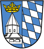
Coat of arms
The coat of arms displays:
- left: the pilgrimage Chapel of Grace in the town of Altötting
- right: the blue and white checked pattern of Bavaria
Towns and municipalities

| Towns | Municipalities | |
|---|---|---|
References
- ^ Genesis Online-Datenbank des Bayerischen Landesamtes für Statistik Tabelle 12411-003r Fortschreibung des Bevölkerungsstandes: Gemeinden, Stichtag (Einwohnerzahlen auf Grundlage des Zensus 2011) (Hilfe dazu).
External links
Wikimedia Commons has media related to Landkreis Altötting.
- Official website (German)
- Unofficial website (German)
- v
- t
- e
Urban and rural districts in the Free State of Bavaria in Germany
districts
- Amberg
- Ansbach
- Aschaffenburg
- Augsburg
- Bamberg
- Bayreuth
- Coburg
- Erlangen
- Fürth
- Hof
- Ingolstadt
- Kaufbeuren
- Kempten
- Landshut
- Memmingen
- München (Munich)
- Nürnberg (Nuremberg)
- Passau
- Regensburg
- Rosenheim
- Schwabach
- Schweinfurt
- Straubing
- Weiden
- Würzburg
districts
- Aichach-Friedberg
- Altötting
- Amberg-Sulzbach
- Ansbach
- Aschaffenburg
- Augsburg
- Bad Kissingen
- Bad Tölz-Wolfratshausen
- Bamberg
- Bayreuth
- Berchtesgadener Land
- Cham
- Coburg
- Dachau
- Deggendorf
- Dillingen
- Dingolfing-Landau
- Donau-Ries
- Ebersberg
- Eichstätt
- Erding
- Erlangen-Höchstadt
- Forchheim
- Freising
- Freyung-Grafenau
- Fürstenfeldbruck
- Fürth
- Garmisch-Partenkirchen
- Günzburg
- Haßberge
- Hof
- Kelheim
- Kitzingen
- Kronach
- Kulmbach
- Landsberg
- Landshut
- Lichtenfels
- Lindau
- Main-Spessart
- Miesbach
- Miltenberg
- Mühldorf
- München (Munich)
- Neuburg-Schrobenhausen
- Neumarkt
- Neustadt (Aisch)-Bad Windsheim
- Neustadt an der Waldnaab
- Neu-Ulm
- Nürnberger Land
- Oberallgäu
- Ostallgäu
- Passau
- Pfaffenhofen
- Regen
- Regensburg
- Rhön-Grabfeld
- Rosenheim
- Roth
- Rottal-Inn
- Schwandorf
- Schweinfurt
- Starnberg
- Straubing-Bogen
- Tirschenreuth
- Traunstein
- Unterallgäu
- Weilheim-Schongau
- Weißenburg-Gunzenhausen
- Wunsiedel
- Würzburg
Towns and municipalities in Altötting district | ||
|---|---|---|
 | ||
Authority control databases | |
|---|---|
| International |
|
| National |
|
48°15′N 12°45′E / 48.25°N 12.75°E / 48.25; 12.75


