Bükk
Section of the North Hungarian Mountains
| Bükk | |
|---|---|
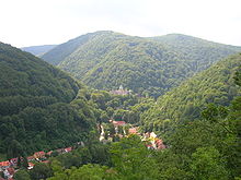 Alsó-Hámor viewed from Szeleta cave. | |
| Location | Borsod, Heves Hungary |
| Highest point | Szilvási-kő (Southern peak of Kettős-bérc), 960,7 m[1] |
| Terrain | Lower mountains |

The Bükk Mountains (Hungarian: [ˈbykː]) are a section of the North Hungarian Mountains of the Inner Western Carpathians. Much of the area is included in the Bükk National Park.
Geography
Although Kékes, the highest point in Hungary, is not here but in the nearby Mátra Mountains, the average height of the Bükk Mountains–with more than 20 peaks higher than 900 m–exceeds that of Mátra. The highest point of Bükk is Kettős bérc (961 m),[2] the third highest main peak in Hungary after Kékes and Galyatető.
There are 1,115[3] known caves in the mountain range, including Bányász-barlang (Miner cave, 274 m) and István-lápa (254 m), the deepest caves in Hungary, the archaeologically important Szeleta cave, the Cave Bath (a main tourist attraction of Miskolc-Tapolca), the Anna Cave, and the István Cave. 52 of the caves are protected because of their fauna and microclimate.
The mountain range is also famous for its skiing facilities located around Bánkút. There are a number of maintained ski slopes equipped with several J-bar lifts. The long traditions of skiing – on the racing and recreational levels – in Bükk are fostered by local enthusiasts constituting the "Bánkút Ski Club" also in charge of operating and developing one of the largest alpine ski centres in Hungary (http://www.bankut.hu).
Gallery
-
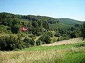 Forest near Bükkszentkereszt.
 -
 Entrance of Istállós-kő Cave
 -
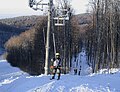 Ski lifts and slopes covered with natural snow in 2006


References
Notes
Sources
- Lénárt, László (November 2006). "Karst water potential of Bükk area – environmental tasks for long term utilization" (PDF). Észak-magyarországi stratégiai füzetek. Series 3 (2). MTA Regionális Kutatások Központja. Retrieved 2009-03-30. [dead link]
- Rakaczky, István (1996). A Bükk turistakalauza. Miskolc: Bíbor Kiadó. ISBN 963-85610-1-7.
- "Állami Ménesgazdaság Szilvásvárad". Állami Ménesgazdaság Szilvásvárad. 2007. Archived from the original on 2009-01-04. Retrieved 2008-02-14.
External links
Wikivoyage has a travel guide for B%C3%BCkk.
- office miskolc/ARC show your card Archived 2020-10-28 at the Wayback Machine
- Bükk National Park
- Marcel Loubens Caving Club
- Accommodation in Bükk
- v
- t
- e
- Alpokalja
- Kőszeg Mountains
- Sopron Mountains
- Vas Hills
- Balfi Hills

- Hanság
- Fertőzug
- Neusiedl Basin
- Rábaköz
- Szigetköz
- Marcal Basin
- Moson Plain
- Komárom-Esztergom Plain
- Baranya
- Zala Hills
- Inner Somogy
- Outer Somogy
- Zselic
- Völgység
- Szekszárd Hills
- Baranya Hills
- Villány Mountains
- Keszthely Mountains
- Tapolca Basin
- Balaton Uplands
- Bakony
- Bakonyalja
- Sokoró
- Vértesalja
- Velence Hills
- Gerecse Mountains
- Buda Hills
- Pilis Mountains
- Visegrád Mountains
- Vértes Mountains
- Mecsek
- Outer Somogy
- Inner Somogy
- Tolna-Baranya Hills
- Balaton Basin
Mountains
48°05′N 20°30′E / 48.083°N 20.500°E / 48.083; 20.500
Authority control databases | |
|---|---|
| International |
|
| National |
|
 | This Hungarian geography article is a stub. You can help Wikipedia by expanding it. |
- v
- t
- e


