Balatonfüred District
Districts of Hungary in Veszprém
Balatonfüredi District Balatonfüredi járás | |
|---|---|
Districts of Hungary | |
 Coat of arms | |
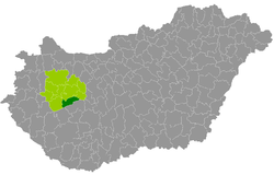 Balatonfüredi District within Hungary and Veszprém County. | |
| Country |  Hungary Hungary |
| County | Veszprém |
| District seat | Balatonfüred |
| Area | |
| • Total | 357.75 km2 (138.13 sq mi) |
| • Rank | 5th in Veszprém |
| Population (2011 census) | |
| • Total | 23,849 |
| • Rank | 7th in Veszprém |
| • Density | 67/km2 (170/sq mi) |
Balatonfüred (Hungarian: Balatonfüredi járás) is a district in southern part of Veszprém County. Balatonfüred is also the name of the town where the district seat is found. The district is located in the Central Transdanubia Statistical Region.
Geography
Balatonfüred District borders with Veszprém District to the north, Balatonalmádi District to the east, Siófok District and Fonyód District (Somogy County) to the south, Tapolca District to the west. The number of the inhabited places in Balatonfüred District is 22.
Municipalities
As of 1 January 2013,[1] the district consists of one town (bold) and 21 villages.
- Alsóörs (1,586)
- Aszófő (392)
- Balatonakali (644)
- Balatoncsicsó (214)
- Balatonfüred (13,313) – district seat
- Balatonszepezd (393)
- Balatonszőlős (625)
- Balatonudvari (310)
- Csopak (1,741)
- Dörgicse (254)
- Lovas (428)
- Monoszló (120)
- Óbudavár (53)
- Örvényes (158)
- Paloznak (441)
- Pécsely (526)
- Szentantalfa (433)
- Szentjakabfa (109)
- Tagyon (84)
- Tihany (1,358)
- Vászoly (247)
- Zánka (821)
See also
References
- ^ "A KSH 2013. évi helységnévkönyve". ksh.hu. Retrieved 2017-10-27.
External links
- Postal codes of the Balatonfüred District

46°57′40″N 17°52′27″E / 46.96123628544036°N 17.874245890752643°E / 46.96123628544036; 17.874245890752643
 | This Veszprém county location article is a stub. You can help Wikipedia by expanding it. |
- v
- t
- e


