Basudih
Village in Jharkhand, India
23°58′59″N 87°06′09″E / 23.98298°N 87.10255°E / 23.98298; 87.10255 India
India (2001)
815359
Basudih is a village in Nala block, Jamtara district, Jharkhand state, India has a Population (2001 Census) of 500 in about 50 families.
Geography


15km
10miles
10miles
B
I
H
A
R
W
E
S
T
B
E
N
G
A
L
Mayurakshi River
Ajay River
Barakar River
Massanjore
Dam
Dam
D

Rasikpur
CT
Purana
Dumka
Dumka
CT
Dudhani
CT
Karmatanr
CT
Mihijam
M
Jamtara
M
Basukinath
M
Dumka
M
Madhupur
M
Jasidih
M
Deoghar
M
Narayanpur
R
Nala
R
Kundahit
R
Fatehpur
R
Bindapathar
R
Basudih
R
Bagdahari
R
Tongra
RV
Taljhari
R
Shikaripara
R
Saraiyahat
R
Ranishwar
R
Ramgarh
R
Masalia
R
Maluti
R
Kathikund
R
Jarmundi
R
Jama
R
Hansdiha
R
Gopikandar
R
Sarwan
R
Sarath
R
Palojori
R
Mohanpur
R
Margomunda
R
Karon
R
Devipur
R
Sonaraithari
R
Chitra
R
Cities, towns and locations in the Deoghar, Dumka and Jamtara districts in Santhal Pargana Division
M: Municipality, CT: census town, R: Rural/ Urban centre, D: Dam,
Owing to space constraints in the small map, the actual locations in a larger map may vary slightly
M: Municipality, CT: census town, R: Rural/ Urban centre, D: Dam,
Owing to space constraints in the small map, the actual locations in a larger map may vary slightly
Location
Basudih is located at 23°58′59″N 87°06′09″E / 23.98298°N 87.10255°E / 23.98298; 87.10255.
Overview
The map shows a large area, which is a plateau with low hills, except in the eastern portion where the Rajmahal hills intrude into this area and the Ramgarh hills are there. The south-western portion is just a rolling upland. The entire area is overwhelmingly rural with only small pockets of urbanisation.[1]
Note: The full screen map is interesting. All places marked on the map are linked in the full screen map and one can easily move on to another page of his/her choice. Enlarge the full screen map to see what else is there – one gets railway connections, many more road connections and so on.
Demographics
As of 2001[update] India census, Basudih had a population of 500. Males constitute 51% of the population and females 49%. Basudih has an average literacy rate of 71%, higher than the national average of 59.5%, male literacy is 78%, and female literacy is 62%. In Basudih, 12% of the population is under 6 years of age.
Climate
Basudih has a humid subtropical climate (Köppen climate classification Cwa), with warm, wet summers and mild winters.
| Climate data for Basudih | |||||||||||||
|---|---|---|---|---|---|---|---|---|---|---|---|---|---|
| Month | Jan | Feb | Mar | Apr | May | Jun | Jul | Aug | Sep | Oct | Nov | Dec | Year |
| Record high °C (°F) | 33.3 (91.9) | 35.6 (96.1) | 42.8 (109.0) | 46.3 (115.3) | 48.3 (118.9) | 45.2 (113.4) | 41.5 (106.7) | 38.6 (101.5) | 38.1 (100.6) | 37.6 (99.7) | 35.8 (96.4) | 31.2 (88.2) | 48.3 (118.9) |
| Mean daily maximum °C (°F) | 25.9 (78.6) | 28.9 (84.0) | 34.3 (93.7) | 38.4 (101.1) | 37.5 (99.5) | 35.5 (95.9) | 32.7 (90.9) | 32.5 (90.5) | 32.9 (91.2) | 33.0 (91.4) | 30.5 (86.9) | 27.0 (80.6) | 32.4 (90.4) |
| Mean daily minimum °C (°F) | 10.2 (50.4) | 13.2 (55.8) | 17.4 (63.3) | 22.3 (72.1) | 23.9 (75.0) | 24.7 (76.5) | 24.1 (75.4) | 23.7 (74.7) | 23.6 (74.5) | 21.0 (69.8) | 16.0 (60.8) | 11.1 (52.0) | 19.3 (66.7) |
| Record low °C (°F) | 1.7 (35.1) | 1.8 (35.2) | 5.8 (42.4) | 13.8 (56.8) | 14.5 (58.1) | 17.8 (64.0) | 13.4 (56.1) | 16.8 (62.2) | 13.8 (56.8) | 11.8 (53.2) | 4.8 (40.6) | 2.8 (37.0) | 1.7 (35.1) |
| Average precipitation mm (inches) | 9.0 (0.35) | 15.0 (0.59) | 21.0 (0.83) | 35.0 (1.38) | 72.0 (2.83) | 198.0 (7.80) | 343.0 (13.50) | 293.0 (11.54) | 273.0 (10.75) | 116.0 (4.57) | 9.0 (0.35) | 7.0 (0.28) | 1,391 (54.77) |
| Average rainy days | 1.5 | 2.3 | 2.2 | 2.8 | 6.3 | 11.3 | 18.9 | 16.9 | 14.1 | 5.7 | 1.1 | 0.8 | 83.9 |
| Average relative humidity (%) | 60 | 53 | 47 | 50 | 60 | 73 | 83 | 83 | 81 | 74 | 65 | 62 | 66 |
| Source: NOAA (1971-1990) [2] | |||||||||||||
Gallery
Images of different places in Basudih
-
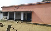 Primary School Basudih
 -
 Lixmi Puja
 -
 Shree Taraniprasad Maji House
 -
 Tulsi Mandir
 -
 Basudih Road
 -
 Water Supply
 -
 Main Road
 -
 Sarso Khet
 -
 Santhal Para
 -
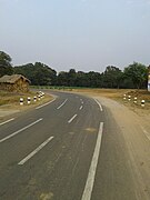 Highway
 -
 Maa Chandi Temple
 -
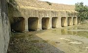 Basudih Dam


References
- ^ Roychoudhury, P.C. "Bihar District Gazetteers: Santhal Parganas". Chapter I: General. Secretariat Press, Patna, 1965. Retrieved 10 November 2020.
- ^ "Basudih Climate Normals 1971-1990". National Oceanic and Atmospheric Administration. Retrieved 22 December 2012.
External links
- Primary School Basudih
See also
- Sarak
- Maji (surname)
- v
- t
- e
Cities, towns and locations in Santhal Parganas
and census towns
| Deoghar district | |
|---|---|
| Dumka district | |
| Godda district | |
| Jamtara district | |
| Pakur district | |
| Sahebganj district |

other than cities and towns
| Deoghar district |
|
|---|---|
| Dumka district |
|
| Godda district | |
| Jamtara district |
|
| Pakur district | |
| Sahebganj district |
- Santhal Pargana Division topics
in other Divisions
- North Chotanagpur
- Kolhan
- Palamu
- South Chotanagpur
 | This article related to a location in Jharkhand is a stub. You can help Wikipedia by expanding it. |
- v
- t
- e


