Beelu National Park
Protected area in Western Australia
31°57′16″S 116°08′59″E / 31.95444°S 116.14972°E / -31.95444; 116.14972Western Australia
Beelu National Park is a national park east of Perth, Western Australia. Lying south of Mundaring, Western Australia, and west of the Mundaring Weir Road, it is part of the group of parks known as the Parks of the Darling Range. The park was formerly named Mundaring National Park.
Mundaring National Park was established and gazetted in 1995 as part of the Protecting Our Old Growth Forests policy of the state government.[2] The park was renamed in 2008 as an acknowledgement of the traditional owners of the area. The word Beelu is derived from the Noongar word for river or stream. The Beelu were the original people of the area, whose district was bounded by the Helena, Swan and Canning Rivers.[3]
The park contains an abundance of native flora including jarrah, marri, Zamia, bull Banksia, sheoak and grass tree.
Facilities
The park contains toilets, wood barbecues, picnic tables and a variety of hiking and mountain biking trails. An information centre, the Perth Hills National Parks Centre, is located within the park. A lookout is located at South Ledge, with a view over Mundaring Weir and Lake CY O'Connor. The largest oak tree in Western Australia is found in Fred Jacoby Park. Two campsites are available for use within the park.
See also
References
- ^ "Department of Environment and Conservation 2009–2010 Annual Report". Annual Report. Department of Environment and Conservation: 48. 2010. ISSN 1835-114X. Archived from the original on 11 January 2011.
- ^ "Mundaring National Park" (PDF). Department of Environment and Conservation - Parks of the Perth Hills. Archived from the original (PDF) on 29 December 2009. Retrieved 1 May 2010.
- ^ "New Aboriginal names for Regional Parks". Roleybushcare. Retrieved 1 May 2010.
- Mitchell, Samille (2008-9) What's in a name? Parks of the Darling Range Landscope Volume 24 number 2, pp. 40–46
Gallery
-
 North Ridge across the Helena Valley
 -
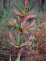 Leucopogon verticillatus flower
 -
 Mundaring Weir Road, Darling Range


- v
- t
- e
- Alexander Morrison
- Avon Valley
- Badgingarra
- Beelu
- Blackwood River
- Boorabbin
- Boorara-Gardner
- Boyndaminup
- Brockman
- Bunuba
- Cape Arid
- Cape Le Grand
- Cape Range
- Cape Range (South)
- Collier Range
- Dalgarup
- Danggu Gorge
- D’Entrecasteaux
- Dirk Hartog Island
- Drovers Cave
- Dryandra Woodland
- Drysdale River
- Easter
- Eucla
- Fitzgerald River
- Forest Grove
- Francois Peron
- Frank Hann
- Gloucester
- Goldfields Woodlands
- Goongarrie
- Gooseberry Hill
- Greater Beedelup
- Greater Dordagup
- Greater Hawke
- Greater Kingston
- Greater Preston
- Greenmount
- Gull Rock
- Hassell
- Helena
- Hilliger
- Houtman Abrolhos Islands
- Jane
- John Forrest
- Kalamunda
- Kalbarri
- Karijini
- Karlamilyi
- Kennedy Range
- Korung
- Lake Muir
- Lakeside
- Lawley River
- Leeuwin-Naturaliste
- Lesmurdie Falls
- Lesueur
- Matuwa Kurrara Kurrara
- Midgegooroo
- Millstream Chichester
- Milyeannup
- Mirima
- Mitchell River
- Moore River
- Mount Augustus
- Mount Frankland
- Mount Frankland North
- Mount Frankland South
- Mount Lindesay
- Mount Roe
- Mungada Ridge
- Murujuga
- Nambung
- Neerabup
- Niiwalarra Islands
- Peak Charles
- Pimbee
- Porongurup
- Prince Regent
- Purnululu
- Scott
- Serpentine
- Shannon
- Sir James Mitchell
- Stirling Range
- Stokes
- Tathra
- Torndirrup
- Tuart Forest
- Tunnel Creek
- Warlibirri
- Walpole-Nornalup
- Walyunga
- Wandoo
- Warren
- Watheroo
- Waychinicup
- Wellington
- West Cape Howe
- Whicher
- William Bay
- Wiltshire-Butler
- Windjana Gorge
- Wolfe Creek Meteorite Crater
- Wooditjup
- Yalgorup
- Yanchep
- Yelverton


