Benson, Saskatchewan
Place in Saskatchewan, Canada
49°26′48″N 102°59′39″W / 49.446570°N 102.994290°W / 49.446570; -102.994290S0C 0L0
Benson is an unincorporated community in the Canadian province of Saskatchewan. It is located between Estevan and Stoughton on Highway 47. Currently it has a curling rink, community hall and the municipal offices of Rural Municipality of Benson No. 35. The geographical location for Benson is north of the Canada–US border and North Dakota.
On July 1, 1935, Benson was hit by a tornado, killing 1, injuring 2, and levelling multiple structures.
Demographics
In the 2021 Census of Population conducted by Statistics Canada, Benson had a population of 95 living in 33 of its 42 total private dwellings, a change of -18.1% from its 2016 population of 116. With a land area of 0.45 km2 (0.17 sq mi), it had a population density of 211.1/km2 (546.8/sq mi) in 2021.[1]
Gallery
-
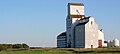 Grain elevator
 -
 The Benson School in 1995 after it closed


References
- ^ "Population and dwelling counts: Canada and designated places". Statistics Canada. February 9, 2022. Retrieved August 31, 2022.
External links
![]() Media related to Benson, Saskatchewan at Wikimedia Commons
Media related to Benson, Saskatchewan at Wikimedia Commons
- v
- t
- e

communities
| Organized hamlets | |
|---|---|
| Special service areas |
 | This article about a location in the Census Division No. 1 of Saskatchewan is a stub. You can help Wikipedia by expanding it. |
- v
- t
- e


