Canelinha
Municipality in South, Brazil
Flag

Seal
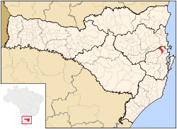
Municipal location
 Brazil
 (2020 [1])
Canelinha is a municipality in the state of Santa Catarina in the South region of Brazil.[2][3] Canelinha is a small town, located 15.2 kilometres (9.4 mi) west of Tijucas and 9.9 kilometres (6.2 mi) by road east of São João Batista.[4] It has an altitude of 17 metres and its population according to the 2020 estimate is 12,398 inhabitants. It has land area of 151.409 km ². The municipality was established on 23 December 1962.[5]
Economy
Canelinha is noted for its ceramics and its large number of potteries, an industry which is very important to the local economy.[6] It also produces clothing, knitwear, shoes, and agricultural products. The locality of Areão in the municipality also contains a motocross track, the Motódromo Arthur Jachovicz, which is a venue for the Campeonatos Catarinense e Brasileiro de motocross.[7]
See also
References
- ^ IBGE 2020
- ^ "Divisão Territorial do Brasil" (in Portuguese). Divisão Territorial do Brasil e Limites Territoriais, Instituto Brasileiro de Geografia e Estatística (IBGE). July 1, 2008. Retrieved December 17, 2009.
- ^ "Estimativas da população para 1º de julho de 2009" (PDF) (in Portuguese). Estimativas de População, Instituto Brasileiro de Geografia e Estatística (IBGE). August 14, 2009. Retrieved December 17, 2009.
- ^ Google (16 May 2013). "Canelinha" (Map). Google Maps. Google. Retrieved 16 May 2013.
- ^ Gomes, Luiz; Bayer, Marcos (2000). Muitas histórias de Tijucas. Editora Insular. p. 65. Retrieved 16 May 2013.
- ^ "Cerâmica" em Canelinha". Guiamais.com. Retrieved 16 May 2013.
- ^ "Motódromo Arthur Jachovicz". Municipal Government of Canelinha. Retrieved 16 May 2013.
External links
- Official site (in Portuguese)
- v
- t
- e
Capital: Florianópolis
| Florianópolis | |
|---|---|
| Tabuleiro | |
| Tijucas |

| Canoinhas | |
|---|---|
| Joinville | |
| São Bento do Sul |
| Campos de Lages | |
|---|---|
| Curitibanos |
| Araranguá | |
|---|---|
| Criciúma | |
| Tubarão |
| Blumenau | |
|---|---|
| Itajaí | |
| Ituporanga | |
| Rio do Sul |
27°17′S 48°47′W / 27.283°S 48.783°W / -27.283; -48.783
 | This Santa Catarina, Brazil location article is a stub. You can help Wikipedia by expanding it. |
- v
- t
- e


