Extremely Severe Cyclonic Storm Chapala[nb 1] was a powerful tropical cyclone that caused moderate damage in Somalia and Yemen during November 2015. Chapala was the third named storm of the 2015 North Indian Ocean cyclone season. It developed as a depression on 28 October off western India, and strengthened a day later into a cyclonic storm. Chapala then rapidly intensified amid favorable conditions. On 30 October, the India Meteorological Department (IMD)[nb 2] estimated that Chapala attained peak three-minute sustained winds of 215 km/h (135 mph). The American-based Joint Typhoon Warning Center (JTWC)[nb 3] estimated sustained winds of 240 km/h (150 mph), making Chapala among the strongest cyclones on record in the Arabian Sea. After peak intensity, Chapala skirted the Yemeni island of Socotra on 1 November, becoming the first hurricane-force storm there since 1922. High winds and heavy rainfall resulted in an island-wide power outage, and severe damage was compounded by Cyclone Megh, which struck Yemen a week later. Chapala means 'scrutiny' in Bengali.
While Chapala encountered less favorable conditions after passing Socotra, it maintained much of its intensity; upon entering the Gulf of Aden on 2 November, it became the strongest known cyclone in that body of water. Chapala brushed the northern coast of Somalia, killing tens of thousands of animals and wrecking 350 houses. Ahead of the cyclone's final landfall, widespread evacuations occurred across southeastern Yemen, including in areas controlled by al-Qaeda, amid the country's ongoing civil war. Early on 3 November, the storm made landfall near Mukalla, Yemen, as a very severe cyclonic storm and the strongest storm on record to strike the nation. Chapala weakened into a remnant low the next day overland. Several years' worth of heavy rainfall inundated coastal areas, damaging roads and hundreds of homes. Eight people died in Yemen, a low total credited to the evacuations, and another 65 were injured. After cyclones Chapala and Megh, several countries, non-government organizations, and agencies within the United Nations provided monetary and material assistance to Yemen. The country faced food and fuel shortages, and residual storm effects contributed to an outbreak of locusts and dengue fever, the latter of which killed seven people.
The monsoon trough spawned a fragmented area of convection, or thunderstorms, southwest of India on 25 October, 2015. The system was located within an environment of moderate wind shear, which prevented early development but decreased over time. On 26 October, the system developed a distinct low-pressure area, which gradually became better defined, with good outflow to the north and south.[4][5][6] At 03:00 UTC on 28 October, the India Meteorological Department (IMD) designated the system as a depression. Nine hours later, the agency upgraded it to a deep depression,[4] and the Joint Typhoon Warning Center (JTWC) classified the system as Tropical Cyclone 04A at 21:00 UTC.[7]
The deep depression moved slowly to the north at first, steered by an anticyclone to the northeast. The IMD upgraded the system to a cyclonic storm at 00:00 UTC on 29 October, giving it the nameChapala. Around the same time, the storm turned towards the west, influenced by another anticyclone to its northwest. With low wind shear,[4] as well as record-warm 30 °C (86 °F) water temperatures,[8] Chapala began a 33-hour period of rapid deepening, in which the barometric pressure dropped 59 hPa (1.74 inHg).[4] The storm developed well-defined rainbands and thunderstorms that consolidated into an eye feature.[9] The JTWC estimated Chapala attained hurricane-force winds of 120 km/h (75 mph) at 12:00 UTC on 29 October.[10] Meanwhile, the IMD upgraded Chapala to a severe cyclonic storm at 09:00 UTC that day, and further to a very severe cyclonic storm at 18:00 UTC.[4] By early on 30 October, Chapala had developed a well-defined eye 22 km (14 mi) wide.[11] Based on satellite intensity estimates using the Dvorak technique, the JTWC assessed Chapala as a high-end Category 4-equivalent cyclone on the Saffir–Simpson hurricane wind scale at 06:00 UTC with one-minute sustained winds of 240 km/h (150 mph).[nb 4][12] Based on their estimate, Chapala was the second-strongest cyclone on record over the Arabian Sea; at the time, only Cyclone Gonu of 2007 was stronger,[13] and Cyclone Kyarr tied it in 2019.[14] Meanwhile, the IMD upgraded Chapala to an extremely severe cyclonic storm at 00:00 UTC on 30 October and estimated peak three-minute sustained winds of 215 km/h (135 mph) at 09:00 UTC. The agency estimated a minimum central pressure of 940 hPa (27.76 inHg).[4]
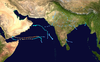
Chapala approaching Yemen on 2 November
At the time of peak intensity, Chapala was moving to the west-southwest due to a ridge to the north.[4] Initially, the IMD forecast that Chapala would intensify further into a super cyclonic storm,[15] and the JTWC anticipated it strengthening into a Category 5-equivalent.[11] Instead, the storm began an eyewall replacement cycle on 30 October, causing the inner eyewall to degrade and an outer eyewall to form; this resulted in a slight drop in intensity.[4] As well, drier air began affecting the storm, causing the thunderstorms around the eye to diminish.[16] Chapala maintained much of its intensity due to strong outflow in all directions,[4] especially to the northeast due to a tropical upper tropospheric trough over India,[16] despite increased wind shear.[17] The new eyewall became established on 31 October, reaching a diameter of 37 km (23 mi), although the thunderstorms around the eye continued to weaken.[4] On 1 November, Chapala passed just north of the island of Socotra,[18] marking the island's first hurricane-force impact since 1922.[19]
After the cyclone passed Socotra, its convective core became better-defined due to improved outflow.[20] Chapala entered the Gulf of Aden on 2 November, becoming the strongest tropical cyclone on record in that region.[21][22] At 12:00 UTC that day, the IMD downgraded the system to a very severe cyclonic storm, after Chapala had been an extremely severe cyclonic storm for 78 hours.[4] The structure became disorganized due to increased easterly wind shear and interaction with the Arabian Peninsula to the north,[23] allowing cooler and drier air to enter the circulation. Around this time, the storm began moving more to the west-northwest toward Yemen, rounding the southwestern periphery of a ridge.[4] Between 01:00–02:00 UTC on 3 November, Chapala made landfall near Mukalla with winds of 120 km/h (75 mph).[4] This marked the first Yemeni hurricane-intensity landfall on record,[24] and the first severe cyclonic storm to hit the country since May 1960.[4] The center straddled the coast before heading inland.[25][26] Chapala quickly weakened over land, degenerating into a depression by 00:00 UTC on 4 November and weakening into a remnant low-pressure area three hours later.[4]
Preparations and impact
Oman
By 30 October, well ahead of the storm, officials in Oman relayed the potential for flash flooding and high waves along the coast.[27] The public was advised to stay away from low-lying areas, while fishermen were asked to avoid venturing into the sea,[28] because of the potential for waves reaching 5 to 7 m (16 to 23 ft) in height.[27] Officials closed all schools in Dhofar Governorate.[27] The storm ultimately passed south of the country, sparing the feared impacts from the cyclone.[29]
Somalia
Ahead of the storm, the threat of high seas spurred the United Nations High Commissioner for Refugees to dissuade Somali and Ethiopian refugees from crossing to Yemen.[30] Large swells produced by Chapala caused extensive coastal damage in Somalia,[31] damaging 280 boats.[32] Eastern Puntland was hardest-hit,[31] where the cyclone damaged 45 km (28 mi) of roads,[32] and nine schools; about 2,000 students had to continue learning in tents.[33] In the Bari region, Chapala wrecked 350 houses,[32] leaving thousands of residents homeless.[31] Also in the region, the storm killed 25,000 animals and downed 5,100 trees.[32] Heavy rainfall from the storm spread to the northeastern tip of Somalia,[8] and westward to the Berbera District in Somaliland. There, the storm killed 3,000 sheep and goats, as well as 200 camels; this severely affected the local nomadic population who rely on the livestock for their livelihood.[34] Continuous rainfall forced families to leave their homes in low-lying areas for higher grounds.[35]
After the storm, the government of Somaliland distributed rice, sugar, and plastic sheets.[36] After Chapala and the subsequent Cyclone Megh, the local Red Cross chapter distributed blankets, sleeping mats, and mattresses to the affected families.[37] The CARE relief agency provided US$300,000 toward relief goods and the restoration of safe water.[32]
Yemen
Chapala during its landfall over Yemen on 3 November
Cyclone Chapala was slated to be the strongest tropical cyclone ever to affect Yemen,[13] and this sparked fears of catastrophic flooding amid the ongoing civil war.[28] The United Nations indicated that Yemen was in the midst of "one of the largest humanitarian crises in the world."[13] Rainfall was forecast to total more than several years' worth of precipitation in some areas, bringing fears of "massive debris flows and flash flooding."[13] Some weather models showed peak accumulations of 400 mm (16 in) or more. Fears of damage and loss of life were compounded by the power vacuum in areas controlled by al-Qaeda, particularly the port city of Mukalla where approximately 300,000 people lived.[19]
The internationally recognized government, which controls most of southern Yemen, announced the suspension of schools in four governorates: Hadhramaut, Socotra, Al Mahrah and Shabwah.[28] Yemen's meteorological agency told residents to stay at least 1 km (0.6 mi) inland.[38] About 18,750 people left their homes ahead of the storm on the Yemen mainland.[39] Most people sheltered in public buildings like schools or hospitals, or stayed with relatives.[40] The World Health Organization distributed gasoline to ambulances and hospitals to ensure they would continue operating effectively.[41]Al-Qaeda controlled Mukalla evacuated a coastal neighborhood.[42]
Socotra
Flooding in Socotra on 1 November
In Socotra, over 1,000 families evacuated to schools set up as shelters.[43] On 1 November, Chapala produced hurricane-force winds and heavy rainfall to the island. Residents described rainfall as the most severe in decades.[42] Northeastern areas of the island were rendered inaccessible due to flooding,[13] forcing residents to ride out the storm on their roofs.[44] Chapala damaged Socotra's main port,[45] and also caused an island-wide power outage.[44] The cyclone destroyed 237 homes on the island and damaged 497 others,[44][46] forcing about 18,000 people to leave their homes.[40] Chapala caused at least 200 injuries.[19] Despite initial reports of three deaths on the island, there were no confirmed fatalities on Socotra, according to the United Nations Office for the Coordination of Humanitarian Affairs (OCHA).[44][47]
Mainland
High winds, strong waves, and heavy rainfall affected the southern Yemen coast.[45] The weather station at Riyan Airport reported sustained winds of 117 km/h (73 mph), with gusts to 143 km/h (89 mph), before it stopped recording; the continued increase in winds supported that Chapala made landfall in Yemen as the equivalent of a hurricane.[48] Some parts of the region received 610 mm (24 in) of rainfall, 700% of the yearly average, in just 48 hours.[45] As the area usually receives less than 50 mm (2 in) of rainfall per year, the ground was unable to absorb much of the water. The resulting runoff triggered flash floods, collected along wadis, or typically dry river beds, and inundated coastal areas several kilometres inland.[44][49]
Across Yemen's mainland, Chapala destroyed 214 homes and damaged another 600.[45] The storm caused eight deaths – five by drowning and three inside collapsed homes.[50][51] One of the deaths occurred as far west as Aden, where a fisherman drowned amid rough seas.[52] Officials attributed the low death toll to the widespread evacuations ahead of the storm.[53] About 65 people were injured,[54] including 25 in Mukalla.[55] Aon Benfield estimated nationwide damage in the hundreds of millions (USD).[56]
Flooding from Chapala damaged crops, killed livestock, and wrecked boats.[45] There, the storm damaged seven health facilities, including two in the nation's fifth-largest city, Mukalla.[45][57] The storm severed phone lines,[44] disrupted water access after damaging pipes,[58] and damaged 90 houses.[55] Residents in Mukalla took shelter in schools as the storm destroyed the waterfront.[59] The city's main hospital was closed because of flooding, but reopened two days later.[60] About 35 km (22 mi) of primary and secondary roads in and around Mukalla, including the coastal road from Aden to the city, were clogged with mud due to the floods and landslides.[46] About 80% of the village of Jilah was flooded,[61] damaging 250 houses.[62]
Aftermath
Satellite image of Chapala after its landfall over Yemen
The Yemeni Government declared a state of emergency for Socotra shortly after the storm's passage on 1 November.[63] The local Red Crescent gave cooked meals and tarps to the island's residents.[64] Several Persian Gulf countries sent 43 planes with supplies to the island by 19 November.[58] Neighboring Oman sent 14 cargo planes' worth of food totaling 270 tons, as well as blankets and tents.[54][52] The United Arab Emirates also sent a ship and a plane carrying 500 tons of food, 10 tons of blankets and tents, and 1,200 barrels of diesel fuel.[65] The International Organization for Migration provided 2,000 shelter kits as well as a medical team to Socotra.[66] Due to damage to the island's main port, residents built a makeshift pathway to help the distribution of aid.[67]
In the days after the storm, airstrikes and attacks continued elsewhere in the country.[46] One week after Chapala, Cyclone Megh followed a similar path.[68] Together, the passages of Chapala and Megh near Socotra and mainland Yemen killed 26 people and displaced 47,000 people.[69] Relief distribution was disrupted due to the poor communications in the region, worsened by the ongoing civil war,[44] with the hardest hit areas under al-Qaeda control;[45] aid trucks had to pass security clearances, resulting in delays.[61] Workers began restoring communications and clearing roads in the days after the storm.[54] By 19 November, most of the displaced residents had returned home, although some remained in shelters due to housing damage.[58] Southern portions of Yemen saw food and fuel shortages following the two storms.[70] Mukalla experienced an outbreak of dengue fever by January 2016 due to the floods, affecting 1,040 people; earlier efforts to kill disease carrying mosquitoes were ineffective due to residual floods and unsanitary conditions. Seven people died due to the outbreak.[71] Flooding from Chapala led to a locust outbreak in March 2016, which spread across Yemen and reached as far as Pakistan.[72]
Agencies under the United Nations and non-government organizations provided assistance to the storm victims,[46] although aid agencies were cautious in helping a city under control of Al Qaeda.[71] The Red Crescent Society of the United Arab Emirates, in conjunction with the Khalifa Foundation and the King Salman Humanitarian Aid and Relief Centre, provided aid to the hardest hit areas of mainland Yemen via an airbridge,[73] as well as over land.[46] United Nations agencies sent 29 trucks carrying 296 tons of non-food items, and the World Health Organization sent a ship from Djibouti with 18 tons of medical supplies.[74] To prevent the spread of disease, officials distributed mosquito nets and began mass-immunizing children under five years old beginning in early November.[54] A national effort to vaccinate against polio was disrupted in six governorates by the cyclone, but was completed by December.[75]Médecins Sans Frontières established a medical clinic in Mukalla while also setting up a water tank.[76] To help with food shortages, the World Food Programme had provided High Energy Biscuits by 30 November to 24,900 people, using pre-stocked supplies.[77] The International Organization for Migration provided 41,000 litres (11,000 US gal) of water per day in Shabwah and Abyan governorates,[66] and also helped clean sewage and storm debris.[78] Agencies also delivered hygiene kits and food to the hardest hit areas.[45] The United Nations High Commissioner for Refugees provided emergency beds, cooking utensils, and other supplies to about 1,600 families.[30]
See also
Tropical cyclones portal
Wikimedia Commons has media related to Cyclone Chapala.
^The Joint Typhoon Warning Center is a joint United States Navy – United States Air Force task force that issues tropical cyclone warnings for the Indian Ocean and other regions.[3]
^The Joint Typhoon Warning Center estimated winds of 250 km/h (155 mph) while the storm was active, but lowered it in a post-season analysis.[11][12][3]
References
^Tropical Cyclone Operational Plan for the Bay of Bengal and the Arabian Sea: 2015(PDF) (2015 ed.). World Meteorological Organization. pp. 11–12. Retrieved 30 March 2020.
^Frequently Asked Questions on Tropical Cyclones (PDF) (Report). India Meteorological Department. p. 47. Retrieved 31 March 2020.
^ ab"Annual Tropical Cyclone Report" (PDF). Joint Typhoon Warning Center. 2016. p. 2. Retrieved 31 March 2020.
^ abcdefghijklmnoExtremely Severe Cyclonic Storm, Chapala over the Arabian Sea (28 October – 04 November 2015): A Report (PDF) (Report). India Meteorological Department. December 2015. Retrieved 27 January 2016.
^"Significant Tropical Weather Advisory". Joint Typhoon Warning Center. 25 October 2015. Archived from the original on 25 October 2015. Retrieved 27 January 2016.
^"Significant Tropical Weather Advisory". Joint Typhoon Warning Center. 26 October 2015. Archived from the original on 26 October 2015. Retrieved 27 January 2016.
^Tropical Cyclone 04A (Four) Warning Nr 001 (Report). Joint Typhoon Warning Center. 28 October 2015. Archived from the original on 29 October 2015. Retrieved 27 January 2016.
^ abKeith Cressman. Tropical Cyclone Chapala 28 October 2015 – 4 November 2015 (PDF) (Report). Desert Locust Information Service. Retrieved 31 March 2020 – via ReliefWeb.
^Tropical Cyclone 04A (Chapala) Warning Nr 003 (Report). Joint Typhoon Warning Center. 29 October 2015. Archived from the original on 29 October 2015. Retrieved 28 January 2016.
^Tropical Cyclone 04A (Chapala) Warning Nr 004 (Report). Joint Typhoon Warning Center. 29 October 2015. Archived from the original on 29 October 2015. Retrieved 28 January 2016.
^ abcTropical Cyclone 04A (Chapala) Warning Nr 007 (Report). Joint Typhoon Warning Center. 30 October 2015. Archived from the original on 30 October 2015. Retrieved 2 November 2015.
^ abKenneth R. Knapp; Michael C. Kruk; David H. Levinson; Howard J. Diamond; Charles J. Neumann (2010). 2015 Super Cyclonic Storm Chapala (2015301N11065). The International Best Track Archive for Climate Stewardship (IBTrACS): Unifying tropical cyclone best track data (Report). Bulletin of the American Meteorological Society. Retrieved 25 March 2020.
^ abcdeJethro Mullen (2 November 2015). "Rare cyclone poses new worries for war-torn Yemen". CNN. Retrieved 2 November 2015.
^Jeff Masters (28 October 2019). "Tropical Cyclone Kyarr (150-mph Winds): Arabian Sea's 2nd Strongest Storm on Record". Scientific American. Retrieved 22 March 2020.
^M. Mohapatra (30 October 2015). Tropical Storm Chapala Advisory 13 issued at 1500 UTC of 30 October 2015 (PDF) (Report). India Meteorological Department. Archived from the original (PDF) on 30 October 2015. Retrieved 2 November 2015.
^ abTropical Cyclone 04A (Chapala) Warning Nr 009 (Report). Joint Typhoon Warning Center. 31 October 2015. Archived from the original on 31 October 2015. Retrieved 2 November 2015.
^Tropical Cyclone 04A (Chapala) Warning Nr 012 (Report). Joint Typhoon Warning Center. 31 October 2015. Archived from the original on 31 October 2015. Retrieved 2 November 2015.
^Tropical Cyclone 04A (Chapala) Warning Nr 015 (Report). Joint Typhoon Warning Center. 1 November 2015. Archived from the original on 1 November 2015. Retrieved 28 January 2016.
^ abcDerek Baldwin (2 November 2015). "Cyclone Chapala to dump 400mm of rainfall in Yemen". Gulf News. Retrieved 2 November 2015.
^Tropical Cyclone 04A (Chapala) Warning Nr 017 (Report). Joint Typhoon Warning Center. 1 November 2015. Archived from the original on 1 November 2015. Retrieved 2 November 2015.
^Priyanka Mogul (3 November 2015). "Cyclone Chapala: Rare tropical storm makes landfall over Yemen, killing three". International Business Times. Retrieved 6 November 2015.
^"Cyclone Chapala nearing landfall over Yemen". Met Office News Blog. 2 November 2015. Retrieved 6 November 2015.
^Tropical Cyclone 04A (Chapala) Warning Nr 021 (Report). Joint Typhoon Warning Center. 2 November 2015. Archived from the original on 3 November 2015. Retrieved 2 November 2015.
^Cassie Bell (4 November 2015). "Cyclone Chapala whirls furiously into Yemen". The Guardian. Retrieved 30 March 2020.
^Tropical Cyclone 04A (Chapala) Warning Nr 023 (Report). Joint Typhoon Warning Center. 3 November 2015. Archived from the original on 3 November 2015. Retrieved 28 January 2016.
^Tropical Cyclone 04A (Chapala) Warning Nr 024 (Report). Joint Typhoon Warning Center. 3 November 2015. Archived from the original on 3 November 2015. Retrieved 28 January 2016.
^ abc"'Extremely severe' cyclone heading for Yemen, Oman: UN". The Daily Star. Agence France-Presse. 30 October 2015. Archived from the original on 23 March 2020. Retrieved 22 March 2020.
^ abcBindu Rai (1 November 2015). "Cyclone Chapala: 30ft high waves; Schools suspended; Oman, Yemen on high alert". Emirates 24/7. Agence France-Presse. Retrieved 1 November 2015.
^NMHEWS End of Chapala Direct Impacts (Report). Government of Oman. 2 November 2015. Retrieved 29 January 2016 – via ReliefWeb.
^ abUNHCR provides emergency relief to cyclone-displaced in Yemen (Report). United Nations High Commissioner for Refugees. 6 November 2015. Retrieved 30 January 2016 – via ReliefWeb.
^ abc"Cyclone leaves thousands homeless in Somalia". News24. Deutsche Presse-Agentur. 3 November 2015. Archived from the original on 8 December 2015. Retrieved 4 November 2015.
^ abcdeThe Humanitarian Coalition and CARE Canada help cyclone survivors in Somalia (PDF) (Report). CARE. 15 December 2015. Retrieved 3 February 2016 – via ReliefWeb.
^UNICEF Somalia Humanitarian Situation Report 11, November 2015 (PDF) (Report). UNICEF. 30 November 2015. Retrieved 3 February 2016 – via ReliefWeb.
^Somalia: Tropical Cyclone Chapala Emergency Plan of Action (EPoA) DREF Operation ° MDRSO004 (Report). International Federation of Red Cross And Red Crescent Societies. 14 November 2015. Retrieved 2 February 2016 – via ReliefWeb.
^Goth Mohamed Goth (7 November 2015). "Somaliland: Government Distributes Relief Aid to Storm affected Bulahaar residents". Somaliland Press. Archived from the original on 3 February 2016. Retrieved 2 February 2016.
^Clár Ní Chonghaile (23 November 2015). "In Somaliland, climate change is now a life-or-death challenge". The Guardian. Retrieved 2 February 2016.
^Emergency Plan of Action (EPoA) Somalia: Tropical Cyclone Chapala (PDF) (Report). International Red Cross and Red Crescent Movement. 14 November 2015. Retrieved 2 February 2016 – via ReliefWeb.
^"Oman, Yemen warn coastal areas as severe cyclone approaches". The Jordan Times. Agence France-Presse. 30 October 2015. Retrieved 22 March 2020.
^Yemen: Cyclone Chapala Flash Update 1 (PDF) (Report). United Nations Office for the Coordination of Humanitarian Affairs. 3 November 2015. Retrieved 29 January 2016.
^ abAnnie Slemrod (5 November 2015). "Will Yemen's storm yet prove disastrous?". IRIN. Archived from the original on 4 February 2016. Retrieved 5 November 2015 – via ReliefWeb.
^WHO scales up response in Yemen for cyclone Chapala (Report). World Health Organization. 2 November 2015. Retrieved 29 January 2016 – via ReliefWeb.
^ abAhmed Al-Haj (1 November 2015). "Yemen's Socotra Island hit by rare cyclone". Associated Press News. Retrieved 19 March 2020.
^"Yemeni island lashed as cyclone heads for mainland". Gulf Times. Agence France-Presse. 1 November 2015. Retrieved 22 March 2020.
^ abcdefg"Yemen's curse: civil war, bombs, and now floods". IRIN. 3 November 2015. Retrieved 29 January 2016 – via ReliefWeb.
^ abcdefghYemen: Cyclone Chapala Flash Update (PDF) (Report). United Nations Office for the Coordination of Humanitarian Affairs. 4 November 2015. Retrieved 5 November 2015 – via ReliefWeb.
^ abcdeYemen: Cyclone Chapala Flash Update 3 (PDF) (Report). United Nations Office for the Coordination of Humanitarian Affairs. 5 November 2015. Retrieved 30 January 2016 – via ReliefWeb.
^"Panic, deaths as Yemen's Socotra hit by new cyclone". Agence France-Presse. 8 November 2015. Retrieved 31 March 2020.
^Bob Henson (3 November 2015). "Chapala Slams Yemen: First Hurricane-Strength Cyclone on Record". Weather Underground. Retrieved 30 March 2020.
^Chapala Drenches the Desert (Report). NASA. 6 November 2015. Retrieved 31 March 2020 – via ReliefWeb.
^"8 killed in Yemen cyclone storm: Official". Middle East Eye. Retrieved 5 November 2015.
^"Yemen – Storm Chapala Leaves 3 Dead, 35 Injured and 40,000 Displaced". Floodlist News. Retrieved 4 November 2015.
^ ab"Aid from neighbours reaches Yemen as cyclone eases". The Jordan Times. Agence France-Presse. 4 November 2015. Retrieved 22 March 2020.
^Yemen: Cyclone Chapala Flash Update 4 (PDF) (Report). United Nations Office for the Coordination of Humanitarian Affairs. 6 November 2015. Retrieved 30 January 2016 – via ReliefWeb.
^ abcdYemen: Cyclone Chapala Flash Update 5 (PDF) (Report). United Nations Office for the Coordination of Humanitarian Affairs. 8 November 2015. Retrieved 2 February 2016 – via ReliefWeb.
^ abYemen – Tropical Cyclone Chapala (ECHO, OCHA, WFP, Log Cluster, Media) (ECHO Daily Flash of 5 November 2015) (Report). European Commission Humanitarian Aid Office. 5 November 2015. Retrieved 30 January 2016 – via ReliefWeb.
^"Global Catastrophe Recap December 2015" (PDF). Aon Benfield. Archived from the original (PDF) on 22 April 2022. Retrieved 2 June 2018.
^Yemen conflict Situation report #18, 26 October – 9 November 2015 (PDF) (Report). World Health Organization. 9 November 2015. Retrieved 2 February 2016 – via ReliefWeb.
^ abcYemen: Cyclones Chapala and Megh Flash Update 11 (PDF) (Report). United Nations Office for the Coordination of Humanitarian Affairs. 19 November 2015. Retrieved 3 February 2016 – via ReliefWeb.
^"Cyclone Chapala bears down on mainland Yemen". BBC. 3 November 2015. Retrieved 3 November 2015.
^Yemen: TC Chapala – The map shows reports on casualties in affected areas (11 Nov 2015) (PDF) (Report). MapAction. 11 November 2015. Retrieved 2 February 2016 – via ReliefWeb.
^ abYemen Situation Update (12 November 2015) (PDF) (Report). World Food Programme. 12 November 2015. Retrieved 2 February 2016 – via ReliefWeb.
^Yemen: Cyclones Chapala and Megh Flash Update 9 (PDF) (Report). United Nations Office for the Coordination of Humanitarian Affairs. 13 November 2015. Retrieved 2 February 2016 – via ReliefWeb.
^وداد-السعودي (1 November 2015). "عشرات الضحايا ونزوح الآلآف من سقطرى اليمنية بسبب "شابالا"" (in Arabic). Arabia Weather. Retrieved 2 November 2015.
^Yemen: Tropical cyclones compound humanitarian suffering (Report). International Committee of the Red Cross. 20 November 2015. Retrieved 3 February 2016 – via ReliefWeb.
^"Khalifa Foundation sends aid to Socotra Archipelago". Emirates News Agency. 24 November 2015. Retrieved 3 February 2016 – via ReliefWeb.
^ abYemen Crisis: IOM Regional Response – Situation Report, 3 December 2015 (PDF) (Report). International Organization for Migration. 3 December 2015. Retrieved 3 February 2016 – via ReliefWeb.
^Yemen: Cyclones Chapala and Megh Flash Update 8 (PDF) (Report). United Nations Office for the Coordination of Humanitarian Affairs. 11 November 2015. Retrieved 2 February 2016 – via ReliefWeb.
^Extremely Severe Cyclonic Storm, Megh over the Arabian Sea (05-10 November 2015): A Report (PDF) (Report). India Meteorological Department. December 2015. Retrieved 22 January 2016.
^Humanitarian Bulletin Yemen Issue 5 (PDF) (Report). United Nations Office for the Coordination of Humanitarian Affairs. 13 November 2015. Retrieved 2 February 2016 – via ReliefWeb.
^Yemen Market Situation Update Weeks 1 and 2: November 2015 (PDF) (Report). World Food Programme. 25 November 2015. Retrieved 3 February 2016 – via ReliefWeb.
^ abSaeed Al Batati (4 January 2016). "Dengue fever spreads in Yemeni city ravaged by cyclone". Al Jazeera. Retrieved 3 February 2016.
^Keith Cressma (12 August 2016). Yemen March 2016–present Post-cyclone Outbreak (PDF) (Report). Desert Locust Information Service. Retrieved 9 April 2020.
^Yemen – Tropical Cyclone Chapala (ECHO, GDACS, JTWC, NMS, NASA, Media) (ECHO Daily Flash of 3 November 2015) (Report). European Commission Humanitarian Aid Office. 3 November 2015. Retrieved 29 January 2016 – via ReliefWeb.
^Yemen Situation Update (18 November 2015) (PDF) (Report). World Food Programme. 18 November 2015. Retrieved 2 February 2016 – via ReliefWeb.
^UNICEF Yemen Crisis Humanitarian Situation Report (21 November – 3 December 2015) (Report). UNICEF. 3 December 2015. Retrieved 3 February 2016 – via ReliefWeb.
^Yemen: Aiding People Affected by Cyclones in Hadhramaut Province (Report). Médecins Sans Frontières. 1 December 2015. Retrieved 3 February 2016 – via ReliefWeb.
^WFP Yemen Situation Report #18, 13 December 2015 (PDF) (Report). 15 December 2015. Retrieved 3 February 2016 – via ReliefWeb. {{cite report}}: Unknown parameter |agency= ignored (help)
^Yemen Crisis: IOM Regional Response – Situation Report, 7 January 2016 (PDF) (Report). International Organization for Migration. 7 January 2016. Retrieved 3 February 2016 – via ReliefWeb.


 Extratropical cyclone, remnant low, tropical disturbance, or monsoon depression