Dalton, KwaZulu-Natal
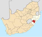
Place in KwaZulu-Natal, South Africa
29°20′S 30°38′E / 29.333°S 30.633°E / -29.333; 30.633 (2011)[1]
3236
Dalton is a village in 11 kilometres (6.8 mi) east of New Hanover and 35 kilometres (22 mi) south of Greytown in the uMshwati Local Municipality of KwaZulu-Natal, South Africa
The town is named after North Dalton in Yorkshire, the hometown of Henry Boast, who organized an immigration to Natal in 1850 of people from Yorkshire. It is the railway junction for the Noodsberg line.[2]
The main local industry is the production of sugarcane, with the Union Cooperative and Illovo Noodsberg mills nearby.
References
- ^ a b c d "Main Place Dalton". Census 2011.
- ^ "Dictionary of Southern African Place Names (Public Domain)". Human Science Research Council. p. 128.
- v
- t
- e
Municipalities and communities of uMgungundlovu District Municipality, KwaZulu-Natal
District seat: Pietermaritzburg
- Bruntville
- Mooi River
- Rosetta
- Townview, Mooi River
 | This KwaZulu-Natal location article is a stub. You can help Wikipedia by expanding it. |
- v
- t
- e


