Decauville railway Narès–Inglis–Topçin–Vatiluk
1 ft 11+5⁄8 in)
Route map | |||||||||||||||||||||||||||||||||||||||||||||||||||
|---|---|---|---|---|---|---|---|---|---|---|---|---|---|---|---|---|---|---|---|---|---|---|---|---|---|---|---|---|---|---|---|---|---|---|---|---|---|---|---|---|---|---|---|---|---|---|---|---|---|---|---|
|
| |||||||||||||||||||||||||||||||||||||||||||||||||||


The Decauville railway Narès–Inglis–Topçin–Vatiluk was around 1916 a 30–35 km (19–22 mi) long narrow-gauge military railway near Thessaloniki in Greece with a gauge of 600 mm (1 ft 11+5⁄8 in)
Route
The 30–35 km (19–22 mi) long semicircular narrow gauge network with a track gauge of 600 mm (1 ft 11+5⁄8 in) from Narès (now Nea Filadelfeia, Νέα Φιλαδέλφεια) via Bumardza (now Bougaríevo, Μπουγαρίεβο), Sari-Omer (Σαρή Ομέρ), Inglis (now Anchialos, Αγχίαλος) and Topçin (now Gefyra, Γέφυρα) to Vatiluk (now Vathylakkos, Βαθύλακκος).[1]
-
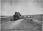 Near Topçin, June 1916
 -
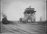 Inglis station
 -
 Tents
Tents -
 Station, Dec. 1916
 -
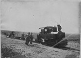 Decauville loco


References
- ^ Vatiluk (Kadikjöј). In: Military Mapping Survey of Austria-Hungary, around 1910.
Wikimedia Commons has media related to Decauville railway Nares-Vatiluk.
- v
- t
- e
Decauville
| Argentina (list) |
|
|---|---|
| Brazil |
|
| France |
|
| Other |
|
- Bathurst (Gambia)
- Cap-Ferret (France)
- Exposition Universelle (1913) (Belgium)
- Mona Island (Puerto Rico)
- Pithiviers–Toury (France)
- Quend-Plage (France)
- Royan (France)
- Rufisque (Senegal)
- Aulnay-sous-Bois (France)
- Corbeil-Ensonnes (France)
- Darvault (France)
- Diano Marina (Italy)
- Marquette-lez-Lille (France)
- Moulins (France)
- Petite-Synthe (France)
- Val-Saint-Lambert (Belgium)
 Category
 Commons

40°45′50″N 22°42′00″E / 40.7640°N 22.7000°E / 40.7640; 22.7000 \


