Everettville, West Virginia
Unincorporated community in West Virginia
39°33′49″N 80°03′47″W / 39.56361°N 80.06306°W / 39.56361; -80.06306 United States
 West Virginia
 Monongalia
Everettville is an unincorporated community in Monongalia County, West Virginia, United States. Everettville is located along County Route 45 and Little Indian Creek, 7.3 miles (11.7 km) southwest of Morgantown.[2] Everettville had a post office, which closed on November 2, 2002.[3]
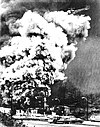
On April 30, 1927, an explosion at the Federal No. 3 Coal Mine in Everettville caused the death of approximately 111 coal miners, a disaster that ranks among the deadliest coal mine accidents in United States history.[4]
Legendary college football coach John McKay was born in Everettville.
References
- ^ "Everettville". Geographic Names Information System. United States Geological Survey, United States Department of the Interior.
- ^ Monongalia County, West Virginia General Highway Map (PDF) (Map). West Virginia Department of Transportation. 2011. p. 2. Archived from the original (PDF) on April 25, 2012. Retrieved March 7, 2012.
- ^ "Postmaster Finder - Post Offices by ZIP Code". United States Postal Service. Archived from the original on October 17, 2020. Retrieved March 7, 2012.
- ^ "The Disaster of April 30, 1927 | www.wveha.org/history". www.wveha.org. Archived from the original on October 12, 2010.
- v
- t
- e
Municipalities and communities of Monongalia County, West Virginia, United States
County seat: Morgantown

localities
- Arnettsville
- Baker Ridge
- Behler
- Bertha Hill
- Bowlby
- Brewer Hill
- Browns Chapel
- Bula
- Canyon
- Chaplin
- Cheat Neck
- Chestnut Ridge
- Clinton Furnace
- Core
- Crossroads
- Crown
- Daybrook
- Dellslow
- Delmar
- Easton
- Edna
- Everettville
- Fieldcrest
- Flaggy Meadow
- Fort Grand
- Fort Martin
- Georgetown
- Greer
- Greystone
- Gum Spring
- Hagans
- Halleck
- Harmony Grove
- Hilderbrand
- Hoard
- Hog Eye
- Holman
- Hunting Hills
- Jaco
- Jakes Run
- Jere
- Kimberly
- Klondike
- Laurel Point
- Little Falls
- Lowsville
- Macdale
- Maidsville
- Maple
- McCurdyville
- McMellin
- Miracle Run
- Mooresville
- Morgan Heights
- National
- New Hill
- Opekiska
- Osgood
- Pedlar
- Pierpont
- Pioneer Rocks
- Price
- Price Hill
- Pursglove
- Ragtown
- Randall
- Richard
- Ridgedale
- Ringgold
- Rock Forge
- Rosedale
- Saint Cloud
- Saint Leo
- Sandy
- Scotts Run
- Smithtown
- Stewartstown
- Suncrest Lake
- Sunset Beach
- Sturgisson
- The Mileground
- Triune
- Tyrone
- Uffington
- Van Voorhis
- Wadestown
- Wana
- West Sabraton
- West Van Voorhis
- Worley
- West Virginia portal
- United States portal
Deadliest coal mine disasters in the United States | ||
|---|---|---|
|  | |
 | This article about a location in Monongalia County, West Virginia is a stub. You can help Wikipedia by expanding it. |
- v
- t
- e


