Greenhill Road
Road in Adelaide, South Australia
Greenhill Road South Australia | |
|---|---|
 | |
| Coordinates |
|
| General information | |
| Type | Road |
| Location | Adelaide |
| Length | 27.7 km (17 mi)[1] |
| Route number(s) |
|
| Former route number |  (1998–2017) (1998–2017)(Wayside–Glenside) |
| Major junctions | |
| West end |  Richmond Road Richmond RoadKeswick, Adelaide |
| |
| East end |  Onkaparinga Valley Road Onkaparinga Valley RoadBalhannah, South Australia |
| Location(s) | |
| Region | Eastern Adelaide, Adelaide Hills[2] |
| Major suburbs | Parkside, Glenside, Burnside, Greenhill, Uraidla, Carey Gully |


Greenhill Road is a major road in Adelaide, South Australia,[3] that provides a connection to the eastern and hills suburbs. Its western section, running along the south side of Adelaide Parklands, forms part of Adelaide's City Ring Route.
Route
The eastern end of Greenhill Road is in Balhannah in the Adelaide Hills. It winds through Carey Gully, Uraidla, Summertown and Greenhill as a two-lane road.
In the metropolitan area, it is four lanes and passes by the City of Burnside suburbs of Burnside, Hazelwood Park, Linden Park, Tusmore, Toorak Gardens, Dulwich and Glenside until it reaches the edge of the Adelaide Parklands. The road then expands to six lanes and heads past Eastwood and the City of Unley suburbs of Parkside, Unley and Wayville as part of the City Ring Route. This section was originally designated "Park Terrace".[4]
Greenhill Road continues west as Richmond Road from the intersection of Anzac Highway.
Major intersections
-
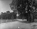 Horse and cart using Greenhill Road, 1915
 -
 Greenhill Road near Linden Park, facing east towards the Adelaide Hills
 -
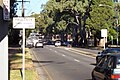 Greenhill Rd in Hazelwood Park looking toward Glynburn Road roundabout and the hills


See also
 Australian Roads portal
References
- ^ a b c Google (16 June 2022). "Greenhill Road" (Map). Google Maps. Google. Retrieved 16 June 2022.
- ^ "Location SA Map viewer with regional layers". Government of South Australia. Retrieved 16 June 2022.
- ^ 2003 Adelaide Street Directory, 41st Edition. UBD (A Division of Universal Press Pty Ltd). 2003. ISBN 0-7319-1441-4.
- ^ "Motoring News". The News. Adelaide: National Library of Australia. 23 November 1953. p. 20. Retrieved 28 July 2014.
- ^ "Location SA Map viewer with LGA layers". Government of South Australia. Retrieved 16 June 2022.
- ^ "Location SA Map viewer with suburb layers". Government of South Australia. Retrieved 16 June 2022.
- v
- t
- e
 Road infrastructure in Adelaide


- Anzac Highway
- Adelaide–Mannum Road (North East Road)
- Gawler Bypass
- Glen Osmond Road
- Grand Junction Road
- Main North Road
- Main South Road
- Mount Barker Road
- Port Road
- Port Wakefield Road
- Portrush/Lower Portrush/Ascot/Taunton/Hampstead Roads
- Salisbury Highway
- Sir Donald Bradman Drive
- South Road
- Victor Harbor Road
- Churchill Road
- City Ring Route
- Cross Road
- Daws Road
- Elder Smith Road
- Flagstaff Road
- Fullarton Road
- Goodwood Road
- Grange Road
- Greenhill Road
- Henley Beach Road
- Kensington Road
- McIntyre/King Roads
- Magill Road
- Marion Road
- Melbourne Street
- Montacute Road
- Montague Road
- O'Connell Street
- Panalatinga Road
- Payneham/Lower North East Roads
- Philip Highway
- Prospect Road
- Regency/Muller Roads
- Tapleys Hill/Brighton/Ocean/Lonsdale/Dyson/Murray Roads
- The Parade
- Torrens Road
- Unley Road
- Victoria Road
- Angas Street
- East Terrace
- Carrington Street
- Currie Street
- Flinders Street
- Franklin Street
- Gawler Place
- Gilbert Street
- Gilles Street
- Gouger Street
- Grenfell Street
- Grote Street
- Halifax Street
- Hindley Street
- Jeffcott Street
- King William Street
- Morphett Street
- North Terrace
- Pirie Street
- Pulteney Street
- Rundle Mall
- Rundle Street
- South Terrace
- Sturt Street
- Wakefield Street
- Waymouth Street
- West Terrace
- Wright Street
34°57′04″S 138°41′16″E / 34.951207°S 138.687673°E / -34.951207; 138.687673
 | This article about a place in Adelaide is a stub. You can help Wikipedia by expanding it. |
- v
- t
- e
 | This Australian road or road transport-related article is a stub. You can help Wikipedia by expanding it. |
- v
- t
- e


