Gyál
Town in Pest, Hungary
Flag

Coat of arms
 Hungary
 (2007)
2360
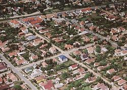
Gyál [ɟaːl] is a town in Pest county, Budapest metropolitan area, Hungary. It has a population of 22,552. In 1949 it had only 4,104 inhabitants. During the socialist era, Gyál become a garden suburb of Budapest.
Twin towns – sister cities
 Chibed, Romania

References
- ^ "Testvértelepülés" (in Hungarian). Gyál. Retrieved 2021-04-07.
External links
Wikimedia Commons has media related to Gyál.
- Official website in Hungarian
- Street map (in Hungarian)


Authority control databases | |
|---|---|
| International |
|
| National |
|
| Geographic |
|
 | This Pest County location article is a stub. You can help Wikipedia by expanding it. |
- v
- t
- e


