Hohenstoffeln
You can help expand this article with text translated from the corresponding article in German. (June 2010) Click [show] for important translation instructions.
- View a machine-translated version of the German article.
- Machine translation, like DeepL or Google Translate, is a useful starting point for translations, but translators must revise errors as necessary and confirm that the translation is accurate, rather than simply copy-pasting machine-translated text into the English Wikipedia.
- Do not translate text that appears unreliable or low-quality. If possible, verify the text with references provided in the foreign-language article.
- You must provide copyright attribution in the edit summary accompanying your translation by providing an interlanguage link to the source of your translation. A model attribution edit summary is
Content in this edit is translated from the existing German Wikipedia article at [[:de:Hohenstoffeln]]; see its history for attribution. - You may also add the template
{{Translated|de|Hohenstoffeln}}to the talk page. - For more guidance, see Wikipedia:Translation.
| Hohenstoffeln | |
|---|---|
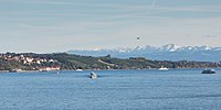
 Hohenstoffeln (center) and Hohenkrähen (right) | |
| Highest point | |
| Elevation | 844 m (2,769 ft) |
| Geography | |
| Location | Baden-Württemberg, Germany |
Hohenstoffeln is a double peaked mountain of volcanic origin in the Hegau region (Konstanz district) of southern Baden-Württemberg, Germany.
- v
- t
- e
Lake Constance (Bodensee)
- Austria
- Vorarlberg
- Bregenz
- Vorarlberg
- Germany
- Baden-Württemberg
- Bodenseekreis
- Konstanz
- Bavaria
- Lindau
- Baden-Württemberg
- Switzerland
- Appenzell Ausserrhoden
- Schaffhausen
- St. Gallen
- Rorschach
- Thurgau
| Austria | |
|---|---|
| Germany |
|
| Switzerland |
|


- Bodanrück Peninsula
- Dominicans Island
- Entlibühl
- Galgeninsel
- Hoy
- Liebesinsel
- Lindau
- Mainau
- Mettnau Peninsula
- Reichenau
- Triboldingerbohl
- Vogelinsel
- Werd
- Marien Gorge
- Spetzgarter Gorge
- Appenzell Alps
- Hegau
- Hohenkrähen
- Hohenstoffeln
- Hohentwiel
- Schiener Berg
- Pfänder
- Seerücken
- Obersee
- Bay of Bregenz
- Constance Hopper
- Überlinger See
- Rhine Delta
- Untersee
- Gnadensee
- Markelfinger Winkel
- Rheinsee
- Wollmatinger Ried
- Zeller See
| Buildings |
|
|---|---|
| Touristic |
| Authority control databases |
|
|---|
47°48′N 8°45′E / 47.800°N 8.750°E / 47.800; 8.750
 | This Baden-Württemberg location article is a stub. You can help Wikipedia by expanding it. |
- v
- t
- e


