Jászfényszaru
Town in Jász-Nagykun-Szolnok, Hungary

Flag

Coat of arms
 Hungary
 (2015)
5126
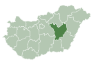
Jászfényszaru is a town in Jász-Nagykun-Szolnok county, in the Northern Great Plain region of central Hungary.
Geography
It covers an area of 76.16 km2 (29 sq mi) and has a population of 5567 people (2015).[1] It is the meeting of three regions: the North-Hungary, the North-Plain and the Central region. The neighbouring towns are: Hatvan, Csány and Boldog (Heves county), Pusztamonostor (Jász-Nagykun-Szolnok county), Zsámbok, Szentlőrinckáta and Tóalmás (Pest county). Jászfényszaru is at the mouth of Zagyva and Galga rivers. The town has 2 twin-cities: Zakliczyn (Poland) and Bors (Romania).
It has the second largest Samsung factory in Europe after the Slovakian one.
Twin towns – sister cities
Jászfényszaru is twinned with:[2]
 Borș, Romania
 Hat, Ukraine
 Kiskunfélegyháza, Hungary
 Zakliczyn, Poland


References
- ^ a b Gazetteer of Hungary, 1 January 2015. Hungarian Central Statistical Office. 3 September 2015
- ^ "Testvértelepüléseink". jaszfenyszaru.hu (in Hungarian). Jászfényszaru. Retrieved 28 March 2021.
External links
Wikimedia Commons has media related to Jászfényszaru.
- Official website in Hungarian, English, German and Polish

| ||
|---|---|---|
| City with county rights |
|   |
| Towns | ||
| Large villages | ||
| Villages |
| |
| Other topics |
| |
Authority control databases | |
|---|---|
| International |
|
| National |
|
 | This Jász-Nagykun-Szolnok location article is a stub. You can help Wikipedia by expanding it. |
- v
- t
- e


