Junction, Illinois
Village in Illinois, United States
37°43′22″N 88°14′17″W / 37.72278°N 88.23806°W / 37.72278; -88.23806 (2010)
(2019)[2]
62954
Junction is a village in Gallatin County, Illinois, United States. The population was 56 at the 2020 census.[3]
History
Junction was founded in the 1880s, and was named for its location at the junction of the L&N and B&O railroads. When a post office was established in 1884, it was named "Cypress Junction." The name was changed to "Junction City" in 1888, and shortened to "Junction" in 1894.[4]
Junction's location in a relatively flat area leaves it prone to flooding along the Ohio River, which can cause waters in the nearby Saline River to back up. A major flood in March 1997 displaced several area residents and blocked all but one road leading into the village.[5]
On June 1, 2022, Junction General Baptist Church burned down after lightning struck the steeple.[6]
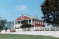
Crenshaw House
The Hickory Hill mansion, almost five miles west of Junction, is the 19th-century home of illegal slave trader and slave breeder John Hart Crenshaw. It was infamously known as the "Old Slave House," as it was used as a criminal front for the kidnapping of free blacks who were illegally sold into the Southern slave trade on the Reverse Underground Railroad, as well as a farm for slave breeding.[7]
Geography
Junction is located at the center of Gallatin County at 37°43′22″N 88°14′17″W / 37.72278°N 88.23806°W / 37.72278; -88.23806 (37.722726, -88.237973).[8] The village lies along Illinois Route 13, a few miles west of the Ohio River, and north of the Shawnee National Forest. The Saline River, a tributary of the Ohio, passes just to the south.
According to the 2010 census, Junction has a total area of 0.883 square miles (2.29 km2), of which 0.88 square miles (2.28 km2) (or 99.66%) is land and 0.003 square miles (0.01 km2) (or 0.34%) is water.[9]
Demographics
| Census | Pop. | Note | %± |
|---|---|---|---|
| 1910 | 800 | — | |
| 1920 | 321 | −59.9% | |
| 1930 | 292 | −9.0% | |
| 1940 | 320 | 9.6% | |
| 1950 | 239 | −25.3% | |
| 1960 | 238 | −0.4% | |
| 1970 | 199 | −16.4% | |
| 1980 | 192 | −3.5% | |
| 1990 | 201 | 4.7% | |
| 2000 | 139 | −30.8% | |
| 2010 | 129 | −7.2% | |
| 2020 | 56 | −56.6% | |
| U.S. Decennial Census[10] | |||
As of the 2020 census, there were 56 people, 35 households, and 38 families residing in the village. The racial makeup of the village was 92.9% White. Hispanic or Latino of any race were 1.79% of the population.[11]
There were 35 households, out of which 10.2% had children under the age of 18 living with them, 68.6% were married couples living together, 22.9% had a female householder with no husband present.
The median income for a household in the village was $32,375, and the median income for a family was $42,500. 45.5% of those over 64 were living below the poverty line.
Notable people
- John Hart Crenshaw, landowner, salt maker, illegal slave trader kidnapper, and illegal slave breeder
Further reading
- 1887. History of Gallatin, Saline, Hamilton, Franklin and Williamson Counties, Illinois. Chicago: Goodspeed Publishing Co.
- Musgrave, Jon, ed. 2002. Handbook of Old Gallatin County and Southeastern Illinois. Marion, Ill.: IllinoisHistory.com. 464 pages.
- Musgrave, Jon. 2004, Rev. ed. 2005. Slaves, Salt, Sex & Mr. Crenshaw: The Real Story of the Old Slave House and America's Reverse Underground R.R.. Marion, Ill.: IllinoisHistory.com. 608 pages.
References
- ^ "2019 U.S. Gazetteer Files". United States Census Bureau. Retrieved July 14, 2020.
- ^ a b "Population and Housing Unit Estimates". United States Census Bureau. May 24, 2020. Retrieved May 27, 2020.
- ^ "Junction, Illinois, USA 2020 Census".
- ^ Edward Callary, Place Names of Illinois (University of Illinois Press, 2010), p. 180.
- ^ Southern Illinois Regional Planning and Development Commission, et. al., "Hazard Mitigation Plan, Gallatin County, Illinois (2011), p. 36.
- ^ "Church destroyed by fire in Gallatin County". June 2, 2022.
- ^ Molly Parker, "Future of Crenshaw House, or Old Slave House, in Question," The Southern, February 21, 2016.
- ^ "US Gazetteer files: 2010, 2000, and 1990". United States Census Bureau. February 12, 2011. Retrieved April 23, 2011.
- ^ "G001 - Geographic Identifiers - 2010 Census Summary File 1". United States Census Bureau. Archived from the original on February 13, 2020. Retrieved August 4, 2015.
- ^ "Census of Population and Housing". Census.gov. Retrieved June 4, 2015.
- ^ "Junction, Illinois, USA 2020 Census".
External links
Wikimedia Commons has media related to Junction, Illinois.
- 1997 flood in Junction
- Junction School
- v
- t
- e
Municipalities and communities of Gallatin County, Illinois, United States
County seat: Shawneetown

- Equality
- Junction
- New Haven
- Old Shawneetown
- Omaha
- Ridgway
communities
- Illinois portal
- United States portal
Authority control databases | |
|---|---|
| International |
|
| National |
|


