KA postcode area
Postcode area within the United Kingdom
55°33′50″N 4°36′14″W / 55.564°N 4.604°W / 55.564; -4.604
KA
Kilmarnock
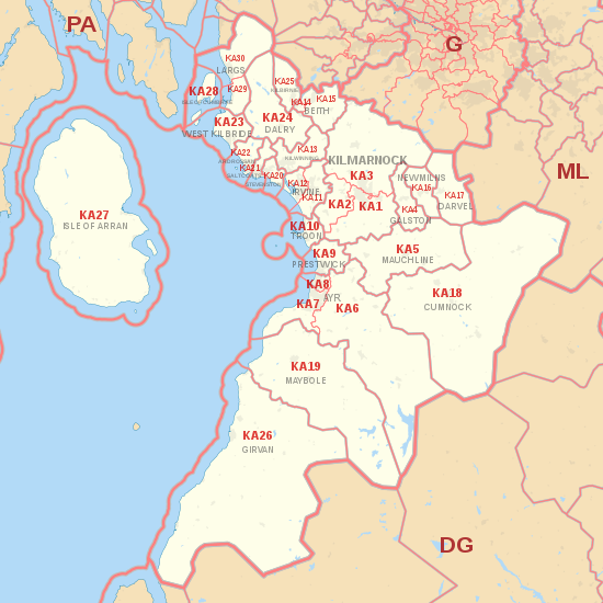
The KA postcode area, also known as the Kilmarnock postcode area,[2][3] is a group of 30 postcode districts in south-west Scotland, within 23 post towns. These cover East Ayrshire, North Ayrshire (including the Isle of Arran) and South Ayrshire.
Coverage
The approximate coverage of the postcode districts:
| Postcode district | Post town | Coverage | Local authority area(s) |
|---|---|---|---|
| KA1 | KILMARNOCK | Kilmarnock Centre, Bonnyton, Grange, Bellfield, Riccarton, Shortlees, Caprington, Hurlford | East Ayrshire |
| KA2 | KILMARNOCK | Knockentiber, Crosshouse, Dundonald | East Ayrshire, South Ayrshire |
| KA3 | KILMARNOCK | Longpark, Hillhead, Knockinlaw, Altonhill, Onthank, Beansburn, Southcraigs, New Farm Loch, Whinpark, Kilmaurs, Stewarton, Dunlop, Lugton, Fullwood, Kingsford, Fenwick, Crookedholm | East Ayrshire, North Ayrshire |
| KA4 | GALSTON | Galston, Moscow | East Ayrshire |
| KA5 | MAUCHLINE | Mauchline, Tarbolton, Catrine, Sorn | East Ayrshire |
| KA6 | AYR | Mossblown, Annbank, Coylton, Dalrymple, Hollybush, Drongan, Rankinston, Patna, Waterside, Dalmellington, Bellsbank | South Ayrshire, East Ayrshire |
| KA7 | AYR | Ayr Centre, Holmston, Forehill, Belmont, Castlehill, Kincaidson, Alloway, Doonfoot, Masonhill, Dunure | South Ayrshire |
| KA8 | AYR | Braehead, Newton on Ayr, Woodfield, Heathfield, Whitletts, Lochside, Dalmilling, Craigie, Wallacetown | South Ayrshire |
| KA9 | PRESTWICK | Prestwick, Monkton | South Ayrshire |
| KA10 | TROON | Troon, Barassie, Muirhead, Loans | South Ayrshire |
| KA11 | IRVINE | Perceton, Lawthorn, Girdle Toll, Stanecastle, Bourtreehill, Broomlands, Dreghorn, Springside | North Ayrshire |
| KA12 | IRVINE | Irvine Centre, Fullarton, Stanecastle | North Ayrshire |
| KA13 | KILWINNING | Kilwinning | North Ayrshire |
| KA14 | BEITH | Beith, Glengarnock, Longboat | North Ayrshire |
| KA15 | BEITH | Beith, Glengarnock, Longboat | North Ayrshire |
| KA16 | NEWMILNS | Newmilns, Greenholm | East Ayrshire |
| KA17 | DARVEL | Darvel | East Ayrshire |
| KA18 | CUMNOCK | Cumnock, Auchinleck, Ochiltree, New Cumnock, Muirkirk, Smallburn, Lugar, Logan | East Ayrshire |
| KA19 | MAYBOLE | Maybole, Crosshill, Straiton, Kirkoswald | South Ayrshire |
| KA20 | STEVENSTON | Stevenston | North Ayrshire |
| KA21 | SALTCOATS | Saltcoats | North Ayrshire |
| KA22 | ARDROSSAN | Ardrossan, Whitlees, Chapelhill | North Ayrshire |
| KA23 | WEST KILBRIDE | West Kilbride | North Ayrshire |
| KA24 | DALRY | Dalry, Drakemyre | North Ayrshire |
| KA25 | KILBIRNIE | Kilbirnie | North Ayrshire |
| KA26 | GIRVAN | Girvan, Turnberry, Dailly, Old Dailly, Ballantrae, Colmonell, Barrhill | South Ayrshire |
| KA27 | ISLE OF ARRAN | Brodick, Lochranza, Machrie, Kilmory, Kildonan, Holy Island | North Ayrshire |
| KA28 | ISLE OF CUMBRAE | Millport | North Ayrshire |
| KA29 | LARGS | Largs, Glenside, Fairlie, Kelburn | North Ayrshire |
| KA30 | LARGS | Largs | North Ayrshire |
Map
KML file (edit • help)
Template:Attached KML/KA postcode area
KML is from Wikidata
See also
References
- ^ "ONS Postcode Directory Version Notes" (ZIP). National Statistics Postcode Products. Office for National Statistics. May 2020. Table 2. Retrieved 19 June 2020. Coordinates from mean of unit postcode points, "Code-Point Open". OS OpenData. Ordnance Survey. February 2012. Retrieved 21 April 2012.
- ^ Address Management Guide (5th ed.). Royal Mail Group plc. March 2007. Retrieved 22 October 2012.
- ^ Office for National Statistics (1999). The Official Yearbook of the United Kingdom (PDF) (2000 ed.). London: The Stationery Office. "UK Postal Areas", map opposite p. 5. ISBN 0-11-621098-2. Retrieved 22 October 2012.
External links
- Royal Mail's Postcode Address File
- A quick introduction to Royal Mail's Postcode Address File (PAF)
- v
- t
- e
- AB
- AL
- B
- BA
- BB
- BD
- BH
- BL
- BN
- BR
- BS
- BT
- CA
- CB
- CF
- CH
- CM
- CO
- CR
- CT
- CV
- CW
- DA
- DD
- DE
- DG
- DH
- DL
- DN
- DT
- DY
- E
- EC
- EH
- EN
- EX
- FK
- FY
- G
- GL
- GU
- HA
- HD
- HG
- HP
- HR
- HS
- HU
- HX
- IG
- IP
- IV
- KA
- KT
- KW
- KY
- L
- LA
- LD
- LE
- LL
- LN
- LS
- LU
- M
- ME
- MK
- ML
- N
- NE
- NG
- NN
- NP
- NR
- NW
- OL
- OX
- PA
- PE
- PH
- PL
- PO
- PR
- RG
- RH
- RM
- S
- SA
- SE
- SG
- SK
- SL
- SM
- SN
- SO
- SP
- SR
- SS
- ST
- SW
- SY
- TA
- TD
- TF
- TN
- TQ
- TR
- TS
- TW
- UB
- W
- WA
- WC
- WD
- WF
- WN
- WR
- WS
- WV
- YO
- ZE
- Related UK lists: Postcode districts
- Post towns
- Postal counties
- London postal district


