Liaquatabad
Suburb in Sindh, Pakistan
Liaquatabad | |
|---|---|
Suburb | |
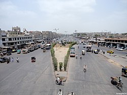 A view of Liaquatabad, Karachi | |
| Country | Pakistan |
| Province | Sindh |
| Established | 1947 |
| Named for | Liaquat Ali Khan |
Liaquatabad, also known as Laloo Khait or Lalukhet Urdu: لیاقت آباد), is a neighborhood in Liaquatabad Town, within Karachi, Sindh, Pakistan. Liaquatabad was named after Nawabzada Liaquat Ali Khan, the first Prime Minister of Pakistan.[1][2]
Liaquatabad is a densely populated area surrounded by several commercial zones. Its markets are known for a range of products including furniture, clothing, shoes and jewellery.[3]
History
Liaquatabad, formerly known as Lalukhet because it was once the agricultural land along the Lyari River belonging to a man named Lalu.[3] The land was purchased by Pakistan Public Works Department from Lalu to settle the Urdu speaking Muslim from India at the time of partition. The Government planned an orderly settlement but the Muslim refugees started haphazard and arbitrary construction after delays.
Demographics
There are several ethnic groups in Liaquatabad including Muhajirs, Sindhis, Kashmiris, Seraikis, Pakhtuns, Balochis, Memons, Bohras and Ismailis. The population of Liaquatabad Town is estimated to be nearly half a million people according to the 1998 census. Muhajirs constitute the overwhelming majority of the population of Liaquatabad. Liaquatabad is located in the centre of Karachi.[2][4]
References
- ^ "کراچی کا قدیم علاقہ لالو کھیت سے لیاقت آباد تک". jang.com.pk.
- ^ a b "Liaquatabad Town". Karachi City Government website. 3 June 2006. Archived from the original on 25 August 2007. Retrieved 28 May 2021.
- ^ a b Sibtain Naqvi (30 July 2017). "CITIES: A KARACHI BY ANY OTHER NAME". Dawn (newspaper). Retrieved 28 May 2021.
- ^ 'Amjad Sabri Dispensary' opens in Liaquatabad The News International (newspaper), Published 15 December 2016, Retrieved 28 May 2021
External links
- Karachi Website.
- v
- t
- e
- Baba Bhit
- Bhutta Village
- Gabo Pat
- Kakapir
- Keamari (locality)
- Keamari Subdivision
- Machar Colony
- Maripur
- Salehabad
- Shams Pir
- Shershah
- Sultanabad
- Abbasi Shaheed
- Bandhani Colony
- Commercial area
- Dak Khana
- Firdous Colony
- Liaquatabad
- Mujahid Colony
- Nazimabad
- Qasimabad
- Rizvia Society
- Sharifabad
- Super Market
- Banaras Colony
- Bhawani Chali
- Frontier Colony
- Islamia Colony
- Jahanabad
- Metrovil
- Old Golimar
- Golimar (new name Gulbahar)
- Pak Colony
- Qasba Colony
- SITE Karachi
- Korangi Industrial Area
- Landhi Industrial Area
- North Karachi Industrial Area
- Federal B Industrial Area
- Korangi Creek Industrial Park
- Bin Qasim Industrial Zone
- Karachi Export Processing Zone
- Pakistan Textile City
- West Wharf Industrial Area
- SITE Super Highway Phase-I
- SITE Super Highway Phase-II
24°54′01″N 67°02′41″E / 24.9002°N 67.0446°E / 24.9002; 67.0446
 | This geography of Karachi-related article is a stub. You can help Wikipedia by expanding it. |
- v
- t
- e


