List of National Historic Landmarks in Maryland
This is a List of National Historic Landmarks in Maryland. There are currently 76 National Historic Landmarks (NHLs) in Maryland. Also included are short lists of former NHLs and of other historic sites of national importance administered by the National Park Service.[1]
Current NHLs
Map all coordinates using OpenStreetMap
Download coordinates as:
- KML
- GPX (all coordinates)
- GPX (primary coordinates)
- GPX (secondary coordinates)
The NHLs are distributed over 17 of Maryland's 23 counties and its one county-equivalent, the independent city of Baltimore.
For consistency, places are listed by their National Historic Landmark program names.
| [2] | Landmark name | Image | Date designated[3] | Location | County | Description |
|---|---|---|---|---|---|---|
| 1 | Accokeek Creek Site |  | July 19, 1964 (#66000909) | Accokeek 38°41′46″N 77°03′07″W / 38.696028°N 77.051833°W / 38.696028; -77.051833 (Accokeek Creek Site) | Prince George's | Archaeological site of a palisaded village occupied from ca. A.D. 1300 to ca. 1630 |
| 2 | Army Medical Museum and Library |  | January 12, 1965 (#66000854) | Silver Spring 39°00′32″N 77°03′14″W / 39.008889°N 77.053889°W / 39.008889; -77.053889 (Army Medical Museum and Library) | Montgomery | This listing presently encompasses a US military medical records and research collection that dates to the 1860s. The original building in Washington, D.C. was demolished in 1969; the collection is now principally with the National Museum of Health and Medicine. The landmark designation is undergoing review. |
| 3 | BALTIMORE (Tug) | 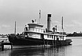 | November 4, 1993 (#93001613) | Baltimore 39°16′22″N 76°36′01″W / 39.27270°N 76.60027°W / 39.27270; -76.60027 (BALTIMORE (Tug)) | City of Baltimore | Oldest steam-powered tugboat in operation in the United States |
| 4 | Baltimore and Ohio Transportation Museum and Mount Clare Station |  | September 15, 1961 (#66000906) | Baltimore 39°17′01″N 76°37′57″W / 39.28352°N 76.63240°W / 39.28352; -76.63240 (Baltimore and Ohio Transportation Museum and Mount Clare Station) | City of Baltimore | Part of oldest American railyard; site of first passenger rail service and first telegraph message. Collections of 19th- and 20th-century artifacts related to America's railroads; 250 pieces of railroad rolling stock; 15,000 artifacts; four nineteenth-century buildings, including the historic roundhouse; a mile of historic track. Larg |
| 5 | Clara Barton House |  | January 12, 1965 (#66000037) | Glen Echo 38°58′03″N 77°08′28″W / 38.96756°N 77.14114°W / 38.96756; -77.14114 (Clara Barton House) | Montgomery | Home of Clara Barton; American pioneer teacher, nurse, and humanitarian; founder of the American Red Cross |
| 6 | Bollman Truss Railroad Bridge |  | February 16, 2000 (#72000582) | Savage 39°08′05″N 76°49′31″W / 39.134722°N 76.825278°W / 39.134722; -76.825278 (Bollman Truss Railroad Bridge) | Howard | Sole surviving example of the first successful all-metal bridge design to be adopted and consistently used on a railroad |
| 7 | Brice House |  | April 15, 1970 (#70000259) | Annapolis 38°58′45″N 76°29′14″W / 38.97917°N 76.48722°W / 38.97917; -76.48722 (Brice House) | Anne Arundel | Preserved 18th century Georgian style brick house |
| 8 | Carrollton Viaduct |  | November 11, 1971 (#71001032) | Baltimore 39°16′24″N 76°39′19″W / 39.27339°N 76.65529°W / 39.27339; -76.65529 (Carrollton Viaduct) | City of Baltimore | Oldest operating railway bridge in the world. |
| 9 | Rachel Carson House |  | December 4, 1991 (#91002058) | Silver Spring 39°02′48″N 77°00′03″W / 39.04667°N 77.00092°W / 39.04667; -77.00092 (Rachel Carson House) | Montgomery | House where Rachel Carson wrote her classic work Silent Spring in 1962 |
| 10 | Casselmans Bridge, National Road |  | January 29, 1964 (#66000391) | Grantsville 39°41′48″N 79°08′37″W / 39.696667°N 79.143611°W / 39.696667; -79.143611 (Casselmans Bridge, National Road) | Garrett | Bridge built in 1813 on the National Road, the nation's first major public works project |
| 11 | Whittaker Chambers Farm |  | May 17, 1988 (#88001824) | Westminster 39°39′35″N 76°58′35″W / 39.659722°N 76.976389°W / 39.659722; -76.976389 (Whittaker Chambers Farm) | Carroll | Farm home of Whittaker Chambers, accuser of Alger Hiss; papers hidden here in a pumpkin led to Hiss's conviction; Chambers wrote Witness, his best-selling autobiography, here |
| 12 | Chase-Lloyd House | 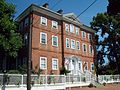 | April 15, 1970 (#70000260) | Annapolis 38°58′52″N 76°29′18″W / 38.98121°N 76.48838°W / 38.98121; -76.48838 (Chase-Lloyd House) | Anne Arundel | Three-story brick Georgian mansion dating from 1769-1774 |
| 13 | Chestertown Historic District |  | April 15, 1970 (#70000263) | Chestertown 39°12′45″N 76°04′10″W / 39.2125°N 76.069444°W / 39.2125; -76.069444 (Chestertown Historic District) | Kent | |
| 14 | College of Medicine of Maryland |  | September 25, 1997 (#97001275) | Baltimore 39°17′16″N 76°37′23″W / 39.28778°N 76.62315°W / 39.28778; -76.62315 (College of Medicine of Maryland) | City of Baltimore | Oldest medical school building in the U.S. |
| 15 | Colonial Annapolis Historic District |  | June 23, 1965 (#66000383) | Annapolis 38°58′41″N 76°29′29″W / 38.978056°N 76.491389°W / 38.978056; -76.491389 (Colonial Annapolis Historic District) | Anne Arundel | NRHP 66000383, and boundary increase NRHP 84003875, in 1984. |
| 16 | USS CONSTELLATION (Frigate) |  | May 23, 1963 (#66000918) | Baltimore 39°17′03″N 76°36′42″W / 39.28426°N 76.61166°W / 39.28426; -76.61166 (USS CONSTELLATION (Frigate)) | City of Baltimore | Constructed in 1854; sloop-of-war, or corvette; second United States Navy ship to carry this famous name |
| 17 | Doughoregan Manor | 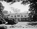 | November 11, 1971 (#71000376) | Ellicott City 39°16′36″N 76°53′35″W / 39.276667°N 76.893056°W / 39.276667; -76.893056 (Doughoregan Manor) | Howard | Built in 1766; until 1832 home of Charles Carroll, last surviving signer of the Declaration of Independence |
| 18 | EDNA E. LOCKWOOD (Bugeye) |  | April 19, 1994 (#86000258) | St. Michaels 38°47′08″N 76°13′10″W / 38.78568°N 76.21941°W / 38.78568; -76.21941 (EDNA E. LOCKWOOD (Bugeye)) | Talbot | Built in 1889; Chesapeake Bay bugeye; last working oyster boat of her kind |
| 19 | Ellicott City Station |  | November 24, 1968 (#68000025) | Ellicott City 39°15′56″N 76°47′43″W / 39.26544°N 76.79529°W / 39.26544; -76.79529 (Ellicott City Station) | Howard | |
| 20 | First Unitarian Church |  | November 7, 1973 (#72001495) | Baltimore 39°17′36″N 76°36′58″W / 39.29340°N 76.61611°W / 39.29340; -76.61611 (First Unitarian Church) | City of Baltimore | |
| 21 | Fort Frederick |  | November 7, 1973 (#73000939) | Big Pool 39°36′33″N 78°01′17″W / 39.609167°N 78.021389°W / 39.609167; -78.021389 (Fort Frederick) | Washington | |
| 22 | Frieda Fromm-Reichmann Cottage |  | January 13, 2021 (#100006277) | Rockville 39°04′59″N 77°09′44″W / 39.0831°N 77.1622°W / 39.0831; -77.1622 (Frieda Fromm-Reichmann Cottage) | Montgomery | |
| 23 | Gaithersburg Latitude Observatory | 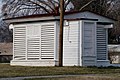 | December 20, 1989 (#85001578) | Gaithersburg 39°08′05″N 77°11′57″W / 39.13472°N 77.19908°W / 39.13472; -77.19908 (Gaithersburg Latitude Observatory) | Montgomery | |
| 24 | Greenbelt, Maryland Historic District |  | February 18, 1997 (#80004331) | Greenbelt 39°00′10″N 76°53′28″W / 39.002778°N 76.891111°W / 39.002778; -76.891111 (Greenbelt, Maryland Historic District) | Prince George's | |
| 25 | Habre-de-venture | 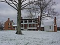 | November 11, 1971 (#72001595) | Port Tobacco 38°31′43″N 77°01′54″W / 38.52872°N 77.03155°W / 38.52872; -77.03155 (Habre-de-venture) | Charles | Now the Thomas Stone National Historic Site. |
| 26 | Hammond-Harwood House | 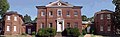 | October 9, 1960 (#66000384) | Annapolis 38°58′52″N 76°29′18″W / 38.98124°N 76.48832°W / 38.98124; -76.48832 (Hammond-Harwood House) | Anne Arundel | |
| 27 | HILDA M. WILLING (Skipjack) |  | April 19, 1994 (#85001089) | Tilghman 38°42′40″N 76°19′53″W / 38.71102°N 76.33142°W / 38.71102; -76.33142 (HILDA M. WILLING (Skipjack)) | Talbot | |
| 28 | His Lordship's Kindness |  | April 15, 1970 (#70000853) | Rosaryville 38°46′44″N 76°50′34″W / 38.778889°N 76.842778°W / 38.778889; -76.842778 (His Lordship's Kindness) | Prince George's | Also known as Poplar Hill. |
| 29 | Homewood |  | November 11, 1971 (#71001033) | Baltimore 39°19′39″N 76°37′09″W / 39.32756°N 76.61917°W / 39.32756; -76.61917 (Homewood) | City of Baltimore | |
| 30 | KATHRYN (Skipjack) |  | April 19, 1994 (#85001090) | Tilghman Island 38°42′40″N 76°19′53″W / 38.71102°N 76.33142°W / 38.71102; -76.33142 (KATHRYN (Skipjack)) | Talbot | |
| 31 | Kennedy Farm |  | November 7, 1973 (#73000941) | Samples Manor 39°22′47″N 77°42′56″W / 39.379722°N 77.715556°W / 39.379722; -77.715556 (Kennedy Farm) | Washington | Headquarters for John Brown's 1859 raid on Harpers Ferry. |
| 32 | LIGHTSHIP NO. 116 "CHESAPEAKE" | 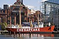 | December 20, 1989 (#80000349) | Baltimore 39°17′01″N 76°36′34″W / 39.28375°N 76.60956°W / 39.28375; -76.60956 (LIGHTSHIP NO. 116 "CHESAPEAKE") | City of Baltimore | Built in 1930 at Charleston Drydock & Machine Co; took on the name of whatever station she was anchored at |
| 33 | London Town Publik House |  | April 15, 1970 (#70000262) | Woodland Beach 38°56′23″N 76°32′25″W / 38.93967°N 76.54026°W / 38.93967; -76.54026 (London Town Publik House) | Anne Arundel | A county alms house |
| 34 | J. C. Lore Oyster House | 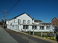 | August 7, 2001 (#84003869) | Solomons 38°19′26″N 76°27′40″W / 38.323889°N 76.461111°W / 38.323889; -76.461111 (J. C. Lore Oyster House) | Calvert | |
| 35 | Maryland Statehouse | 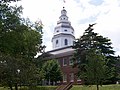 | December 19, 1960 (#66000385) | Annapolis 38°58′36″N 76°29′28″W / 38.97663°N 76.49107°W / 38.97663; -76.49107 (Maryland Statehouse) | Anne Arundel | |
| 36 | Elmer V. McCollum House |  | January 7, 1976 (#76002182) | Baltimore 39°18′49″N 76°41′06″W / 39.313611°N 76.685°W / 39.313611; -76.685 (Elmer V. McCollum House) | City of Baltimore | Home of nutrition researcher Elmer McCollum. |
| 37 | H. L. Mencken House |  | July 28, 1983 (#83004384) | Baltimore 39°17′08″N 76°38′29″W / 39.28556°N 76.64137°W / 39.28556; -76.64137 (H. L. Mencken House) | City of Baltimore | A home of author H. L. Mencken. The house is included in the Union Square-Hollins Market Historic District. |
| 38 | Minor Basilica of the Assumption of the Blessed Virgin Mary |  | November 11, 1971 (#69000330) | Baltimore 39°17′36″N 76°36′58″W / 39.29340°N 76.61611°W / 39.29340; -76.61611 (Minor Basilica of the Assumption of the Blessed Virgin Mary) | City of Baltimore | |
| 39 | Monocacy Battlefield | 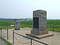 | November 8, 1973 (#66000908) | Frederick 39°22′16″N 77°23′31″W / 39.37115°N 77.39208°W / 39.37115; -77.39208 (Monocacy Battlefield) | Frederick | |
| 40 | Montpelier |  | April 15, 1970 (#70000852) | Laurel 39°03′54″N 76°50′42″W / 39.065°N 76.845°W / 39.065; -76.845 (Montpelier) | Prince George's | |
| 41 | Mount Clare |  | April 15, 1970 (#70000860) | Baltimore 39°16′37″N 76°38′37″W / 39.27697°N 76.64349°W / 39.27697; -76.64349 (Mount Clare) | City of Baltimore | |
| 42 | Mount Royal Station and Trainshed |  | December 8, 1976 (#73002191) | Baltimore 39°18′14″N 76°37′14″W / 39.30378°N 76.62046°W / 39.30378; -76.62046 (Mount Royal Station and Trainshed) | City of Baltimore | |
| 43 | Mount Vernon Place Historic District |  | November 11, 1971 (#71001037) | Baltimore 39°17′51″N 76°36′56″W / 39.297493°N 76.61565°W / 39.297493; -76.61565 (Mount Vernon Place Historic District) | City of Baltimore | |
| 44 | NELLIE CROCKETT (Buy-boat) |  | April 19, 1994 (#94001185) | Georgetown 39°21′40″N 75°52′55″W / 39.36110°N 75.88183°W / 39.36110; -75.88183 (NELLIE CROCKETT (Buy-boat)) | Kent | Chesapeake Bay oyster buy-boat; built in 1926. |
| 45 | Old Lock Pump House, Chesapeake and Delaware Canal |  | January 12, 1965 (#66000390) | Chesapeake City 39°31′26″N 75°48′39″W / 39.52380°N 75.81070°W / 39.52380; -75.81070 (Old Lock Pump House, Chesapeake and Delaware Canal) | Cecil | |
| 46 | William Paca House |  | November 11, 1971 (#71000364) | Annapolis 38°58′46″N 76°29′17″W / 38.97944°N 76.48793°W / 38.97944; -76.48793 (William Paca House) | Anne Arundel | |
| 47 | Peale's Baltimore Museum |  | December 21, 1965 (#66000915) | Baltimore 39°17′24″N 76°36′38″W / 39.29004°N 76.61063°W / 39.29004; -76.61063 (Peale's Baltimore Museum) | City of Baltimore | |
| 48 | Phoenix Shot Tower |  | November 11, 1971 (#69000373) | Baltimore 39°17′19″N 76°36′20″W / 39.28867°N 76.60556°W / 39.28867; -76.60556 (Phoenix Shot Tower) | City of Baltimore | |
| 49 | Edgar Allan Poe House | 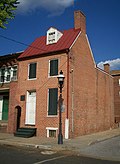 | November 11, 1971 (#71001043) | Baltimore 39°17′21″N 76°38′00″W / 39.28923°N 76.63334°W / 39.28923; -76.63334 (Edgar Allan Poe House) | City of Baltimore | |
| 50 | REBECCA T. RUARK (Skipjack) |  | July 31, 2003 (#85001095) | Tilghman Island 38°42′46″N 76°19′53″W / 38.712778°N 76.331389°W / 38.712778; -76.331389 (REBECCA T. RUARK (Skipjack)) | Talbot | |
| 51 | Ira Remsen House |  | May 15, 1975 (#75002102) | Baltimore 39°17′51″N 76°37′09″W / 39.297462°N 76.619263°W / 39.297462; -76.619263 (Ira Remsen House) | City of Baltimore | |
| 52 | Riversdale Mansion |  | December 9, 1997 (#73002166) | Riverdale 38°57′37″N 76°55′55″W / 38.960278°N 76.931944°W / 38.960278; -76.931944 (Riversdale Mansion) | Prince George's | |
| 53 | Henry August Rowland House | 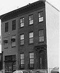 | May 15, 1975 (#75002098) | Baltimore 39°18′02″N 76°37′02″W / 39.300505°N 76.617358°W / 39.300505; -76.617358 (Henry August Rowland House) | City of Baltimore | Home of physicist Henry Augustus Rowland. |
| 54 | St. Mary's City Historic District | 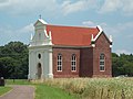 | August 4, 1969 (#69000310) | St. Marys City 38°11′21″N 76°25′56″W / 38.189167°N 76.432222°W / 38.189167; -76.432222 (St. Mary's City Historic District) | St. Mary's | |
| 55 | St. Mary's Seminary Chapel |  | November 11, 1971 (#71001046) | Baltimore 39°17′38″N 76°37′23″W / 39.29401°N 76.62302°W / 39.29401; -76.62302 (St. Mary's Seminary Chapel) | City of Baltimore | |
| 56 | N.S. SAVANNAH (Nuclear Ship) |  | July 17, 1991 (#82001518) | Baltimore 39°15′30″N 76°33′20″W / 39.258472°N 76.555417°W / 39.258472; -76.555417 (N.S. SAVANNAH (Nuclear Ship)) | City of Baltimore | |
| 57 | Schifferstadt |  | December 23, 2016 (#100000833) | Frederick 39°25′24″N 77°25′39″W / 39.423333°N 77.4275°W / 39.423333; -77.4275 (Schifferstadt) | Frederick County | |
| 58 | Sheppard and Enoch Pratt Hospital and Gate House |  | November 11, 1971 (#71000369) | Towson 39°23′28″N 76°37′09″W / 39.391111°N 76.619167°W / 39.391111; -76.619167 (Sheppard and Enoch Pratt Hospital and Gate House) | Baltimore County | |
| 59 | Sion Hill |  | April 27, 1992 (#90000608) | Havre De Grace 39°33′58″N 76°07′39″W / 39.56606°N 76.12740°W / 39.56606; -76.12740 (Sion Hill) | Harford | |
| 60 | Sotterley | 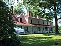 | February 16, 2000 (#72001487) | Hollywood 38°22′47″N 76°32′20″W / 38.379722°N 76.538889°W / 38.379722; -76.538889 (Sotterley) | St. Mary's | |
| 61 | Spacecraft Magnetic Test Facility |  | October 3, 1985 (#85002811) | Greenbelt 39°00′17″N 76°49′31″W / 39.00485°N 76.82541°W / 39.00485; -76.82541 (Spacecraft Magnetic Test Facility) | Prince George's | |
| 62 | Star-Spangled Banner Flag House |  | December 16, 1969 (#69000320) | Baltimore 39°17′08″N 76°36′13″W / 39.28563°N 76.60358°W / 39.28563; -76.60358 (Star-Spangled Banner Flag House) | City of Baltimore | House where Mary Young Pickersgill sewed the large Star-Spangled Banner flag of the United States, to fly over Fort McHenry, inspiring the U.S. national anthem. |
| 63 | Peggy Stewart House | 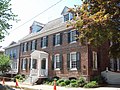 | November 7, 1973 (#73000887) | Annapolis 38°58′55″N 76°29′14″W / 38.98189°N 76.48725°W / 38.98189; -76.48725 (Peggy Stewart House) | Anne Arundel | |
| 64 | USCGC WHEC-37 (Coast Guard cutter) | 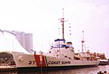 | June 7, 1988 (#88001826) | Baltimore 39°17′09″N 76°36′23″W / 39.285833°N 76.606389°W / 39.285833; -76.606389 (USCGC WHEC-37 (Coast Guard cutter)) | City of Baltimore | |
| 65 | Thomas Point Shoal Light Station | 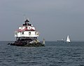 | January 20, 1999 (#75000864) | Annapolis 38°53′56″N 76°26′10″W / 38.899°N 76.436°W / 38.899; -76.436 (Thomas Point Shoal Light Station) | Anne Arundel | |
| 66 | Thomas Viaduct, Baltimore & Ohio Railroad |  | January 28, 1964 (#66000388) | Relay 39°13′12″N 76°42′49″W / 39.22000°N 76.71351°W / 39.22000; -76.71351 (Thomas Viaduct, Baltimore & Ohio Railroad) | Baltimore County & Howard County | |
| 67 | Tolson's Chapel and School |  | January 13, 2021 (#100006233) | 111 E. High St. 39°27′22″N 77°44′47″W / 39.4561°N 77.7464°W / 39.4561; -77.7464 (Tolson's Chapel and School) | Washington | |
| 68 | USS TORSK (Submarine) |  | January 14, 1986 (#86000090) | Baltimore 39°16′58″N 76°36′33″W / 39.28285°N 76.60908°W / 39.28285; -76.60908 (USS TORSK (Submarine)) | City of Baltimore | |
| 69 | Tulip Hill |  | April 15, 1970 (#70000261) | Galesville 38°51′03″N 76°33′02″W / 38.850833°N 76.550556°W / 38.850833; -76.550556 (Tulip Hill) | Anne Arundel | |
| 70 | United States Naval Academy |  | July 4, 1961 (#66000386) | Annapolis 38°59′04″N 76°29′20″W / 38.98443°N 76.48888°W / 38.98443; -76.48888 (United States Naval Academy) | Anne Arundel | |
| 71 | Washington Aqueduct |  | November 7, 1973 (#73002123) | Great Falls, MD and Washington, DC 38°56′15″N 77°06′51″W / 38.9375°N 77.114167°W / 38.9375; -77.114167 (Washington Aqueduct) | Montgomery, MD and District of Columbia | Also in District of Columbia |
| 72 | William Henry Welch House |  | January 7, 1976 (#76002186) | Baltimore 39°18′00″N 76°36′51″W / 39.30008°N 76.61428°W / 39.30008; -76.61428 (William Henry Welch House) | City of Baltimore | |
| 73 | West St. Mary's Manor |  | April 15, 1970 (#70000854) | Drayden 38°11′10″N 76°26′54″W / 38.186111°N 76.448333°W / 38.186111; -76.448333 (West St. Mary's Manor) | St. Mary's | |
| 74 | Whitehall | 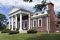 | October 9, 1960 (#66000387) | Annapolis 39°00′15″N 76°25′37″W / 39.004167°N 76.426944°W / 39.004167; -76.426944 (Whitehall) | Anne Arundel | |
| 75 | WILLIAM. B. TENNISON (Buy-Boat) |  | April 19, 1994 (#80001799) | Solomons 38°19′23″N 76°27′39″W / 38.32315°N 76.46089°W / 38.32315; -76.46089 (WILLIAM. B. TENNISON (Buy-Boat)) | Calvert | |
| 76 | Wye House |  | April 15, 1970 (#70000264) | Easton 38°51′12″N 76°10′06″W / 38.853398°N 76.168406°W / 38.853398; -76.168406 (Wye House) | Talbot |
Historic areas of the NPS in Maryland
National Historical Parks, some National Monuments, and certain other areas listed in the National Park system are historic landmarks of national importance that are highly protected already, often before the inauguration of the NHL program in 1960, and are then often not also named NHLs per se. The National Park Service lists these together with the NHLs in the state.[4]
The Clara Barton National Historic Site, Monocacy National Battlefield and Thomas Stone National Historic Site are also NHLs and are listed above (with the latter under its alternative name, Habre de Venture).
| Landmark name | Image | Date established[5] | Location | County | Description | |
|---|---|---|---|---|---|---|
| 1 | Antietam National Battlefield |  | August 30, 1890 | Sharpsburg | Washington | |
| 2 | Chesapeake and Ohio Canal National Historical Park |  | January 8, 1971 | Maryland | multiple counties | Also included in District of Columbia and West Virginia |
| 3 | Fort McHenry National Monument and Historic Shrine | 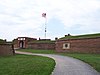 | March 3, 1925 (National Park) August 11, 1939 (National Monument) | Baltimore | City of Baltimore | |
| 4 | Fort Washington Park | 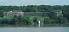 | May 29, 1930 | Fort Washington | Prince George's County | |
| 5 | Hampton National Historic Site |  | June 22, 1948 | Hampton, Maryland | Baltimore County | |
| 6 | Harpers Ferry National Historical Park | 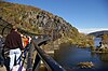 | June 30, 1944 (National Monument) May 29, 1963 (National Historical Park) | Maryland | Washington County | Also included in Virginia and West Virginia |
| 7 | Piscataway Park |  | October 4, 1961 | Accokeek | Prince George's County |
Former National Historic Landmarks
There is one former NHL, Resurrection Manor, which was demolished in 2002 and subsequently delisted.
| # | Landmark name | Image | Date designated | Date withdrawn | Locality | County | Description |
|---|---|---|---|---|---|---|---|
| 1 | Resurrection Manor | 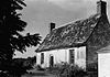 | April 15, 1970 | February 17, 2006 | Hollywood vicinity 38°20′17″N 76°30′34″W / 38.338056°N 76.509444°W / 38.338056; -76.509444 (Resurrection Manor site) | St. Mary's | Demolished in 2002 and replaced by a modern home.[6] |
See also
- National Register of Historic Places listings in Maryland
- List of National Historic Landmarks by state
References
- ^ National Park Service (June 2011). "National Historic Landmarks Survey: List of National Historic Landmarks by State" (PDF). Archived from the original (PDF) on November 5, 2011. Retrieved July 4, 2011..
- ^ Numbers represent an alphabetical ordering by significant words. Various colorings, defined here, differentiate National Historic Landmarks and historic districts from other NRHP buildings, structures, sites or objects.
- ^ The eight-digit number below each date is the number assigned to each location in the National Register Information System database, which can be viewed by clicking the number.
- ^ These are listed on p.112-113 of "National Historic Landmarks Survey: List of National Historic Landmarks by State", November 2007 version.
- ^ National Park Service: National Park System Birthdays.
- ^ NHL webpage on it, for use in article
External links
- "National Historic Landmarks Survey: List of National Historic Landmarks by State--Maryland (71)" (PDF). National Park Service. Retrieved February 8, 2008.
- National Historic Landmarks Program, at National Park Service
- National Register Information System, National Park Service.
- Maryland Historical Markers photographs at the University of Maryland Libraries
- v
- t
- e
- Alabama
- Alaska
- Arizona
- Arkansas
- California
- Colorado
- Connecticut
- Delaware
- Florida
- Georgia
- Hawaii
- Idaho
- Illinois
- Indiana
- Iowa
- Kansas
- Kentucky
- Louisiana
- Maine
- Maryland
- Massachusetts
- Michigan
- Minnesota
- Mississippi
- Missouri
- Montana
- Nebraska
- Nevada
- New Hampshire
- New Jersey
- New Mexico
- New York
- North Carolina
- North Dakota
- Ohio
- Oklahoma
- Oregon
- Pennsylvania
- Rhode Island
- South Carolina
- South Dakota
- Tennessee
- Texas
- Utah
- Vermont
- Virginia
- Washington
- West Virginia
- Wisconsin
- Wyoming
| Insular area | |
|---|---|
| Associated state | |
| Foreign country |
| |
|---|---|
| Topics | |
| Lists by state |
|
| Lists by insular areas | |
| Lists by associated state | |
| Other areas | |
| Related | |
| |


