List of historic places in British Columbia Coast
Map all coordinates using OpenStreetMap
Download coordinates as:
- KML
- GPX (all coordinates)
- GPX (primary coordinates)
- GPX (secondary coordinates)
The following list includes all of the Canadian Register of Historic Places listings in the British Columbia Coast area, excluding Vancouver Island. This includes the following districts:
- Central Coast Regional District
- Kitimat-Stikine Regional District
- Mount Waddington Regional District
- Powell River Regional District
- Skeena-Queen Charlotte Regional District
- Strathcona Regional District
- Sunshine Coast Regional District
| Name | Address | Coordinates | Government recognition (CRHP №) | Image | |
|---|---|---|---|---|---|
| Kitwankul National Historic Site of Canada | Near the confluence of Kitwankul Creek and the Kitwanka River, in Kitwankul Indian Reserve 1 Gitanyow BC | 55°15′48″N 128°03′41″W / 55.2634°N 128.0614°W / 55.2634; -128.0614 (Kitwankul National Historic Site of Canada) | Federal (19634) |  | |
| Dorreen Store and Railway Station | Kitimat-Stikine C BC | 54°50′27″N 128°20′38″W / 54.8409°N 128.3439°W / 54.8409; -128.3439 (Dorreen Store and Railway Station) | Kitimat-Stikine C municipality (20268) |  Upload Photo | |
| Meanskinisht Cemetery | Cedarvale Ferry Road Cedarvale BC | 55°01′22″N 128°18′44″W / 55.0227°N 128.3122°W / 55.0227; -128.3122 (Meanskinisht Cemetery) | Cedarvale municipality (20269) | Upload Photo | |
| Gitwangak Battle Hill | 55°7′10″N 128°1′1″W / 55.11944°N 128.01694°W / 55.11944; -128.01694 (Gitwangak Battle Hill) | Federal (7633) | Q1527840 | 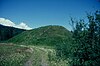 More images | |
| Metlakatla Pass | 54°19′27″N 130°27′29″W / 54.32417°N 130.45806°W / 54.32417; -130.45806 (Metlakatla Pass) | Federal (10473) | Q23768240 | Upload Photo | |
| Kitselas Canyon | 54°36′0″N 128°25′59″W / 54.60000°N 128.43306°W / 54.60000; -128.43306 (Kitselas Canyon) | Federal (10522) | Q1546580 |  More images | |
| Pulteney Point Lighthouse | Southwestern tip of Malcolm Island Port McNeill BC | 50°37′50″N 127°09′18″W / 50.6305°N 127.1550°W / 50.6305; -127.1550 (Pulteney Point Lighthouse) | Federal (200838) | 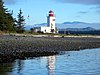 | |
| Powell River Townsite Historic District National Historic Site of Canada | Powell River Powell River BC | 49°52′05″N 124°32′49″W / 49.868°N 124.547°W / 49.868; -124.547 (Powell River Townsite Historic District National Historic Site of Canada) | Federal (10728) | 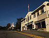 | |
| Dryad Point Lighthouse | Northeast tip of Campbell Island Central Coast Regional District BC | 52°11′06″N 128°06′42″W / 52.1851°N 128.1117°W / 52.1851; -128.1117 (Dryad Point Lighthouse) | Federal (20780) |  | |
| Boat Bluff Lighthouse | Southern tip of Sarah Island Regional District of Kitimat-Stikine BC | 52°38′35″N 128°31′27″W / 52.6430°N 128.5241°W / 52.6430; -128.5241 (Boat Bluff Lighthouse) | Federal (20776) |  | |
| Meziadin Fish Ladder | Meziadin River near its mouth at the Nass River Regional District of Kitimat-Stikine BC | 56°01′20″N 129°09′11″W / 56.0222°N 129.1531°W / 56.0222; -129.1531 (Meziadin Fish Ladder) | Federal (19436) | Upload Photo | |
| Simon Gunanoot Gravesite | Graveyard Point, Bowser Lake Regional District of Kitimat-Stikine BC | 56°25′55″N 129°32′08″W / 56.4319°N 129.5355°W / 56.4319; -129.5355 (Simon Gunanoot Gravesite) | Federal (19434) | Upload Photo | |
| Egg Island Lighthouse | Egg Island, off the coast at the northeast entrance to the Queen Charlotte Strait Central Coast Regional District BC | 51°14′59″N 127°50′11″W / 51.2498°N 127.8364°W / 51.2498; -127.8364 (Egg Island Lighthouse) | Federal (20781) |  | |
| Langara Point Lighthouse | Langara Point Langara Island BC | 54°15′19″N 133°03′34″W / 54.2554°N 133.0594°W / 54.2554; -133.0594 (Langara Point Lighthouse) | Federal (9496, (21113) | Upload Photo | |
| McInnes Island Lighthouse | McInnes Island, off the southern tip of Price Island McInnes Island BC | 52°15′44″N 128°43′18″W / 52.2622°N 128.7216°W / 52.2622; -128.7216 (McInnes Island Lighthouse) | Federal (20798) | Upload Photo | |
| Green Island Lighthouse | Green Island, east of Dundas Island in Chatham Sound Skeena-Queen Charlotte A BC | 54°34′07″N 130°42′31″W / 54.5687°N 130.7086°W / 54.5687; -130.7086 (Green Island Lighthouse) | Federal (20796) | Upload Photo | |
| Capilano Shipwreck | Strait of Georgia south of Savary Island Powell River Regional District BC | 49°52′47″N 124°46′15″W / 49.8796°N 124.7708°W / 49.8796; -124.7708 (Capilano Shipwreck) | British Columbia (10311) | Upload Photo | |
| North Pacific Cannery National Historic Site of Canada | Port Edward Skeena-Queen Charlotte BC | 54°11′41″N 130°13′26″W / 54.1946°N 130.224°W / 54.1946; -130.224 (North Pacific Cannery National Historic Site of Canada) | Federal (12321) |  | |
| Pacific Roundhouse | 35km by rail north of Terrace Pacific BC | 54°46′13″N 128°16′15″W / 54.7702°N 128.2709°W / 54.7702; -128.2709 (Pacific Roundhouse) | Federal (20270) | Upload Photo | |
| Yukon Telegraph Trail | 500km of former telegraph line route in Kitimat-Stikine Regional District Telegraph Creek BC | 57°55′14″N 131°10′07″W / 57.9206°N 131.1685°W / 57.9206; -131.1685 (Yukon Telegraph Trail) | Telegraph Creek municipality (17944) | Upload Photo | |
| Triple Island Lighthouse National Historic Site of Canada | Prince Rupert Skeena-Queen Charlotte BC | 54°17′41″N 130°52′48″W / 54.2946°N 130.88°W / 54.2946; -130.88 (Triple Island Lighthouse National Historic Site of Canada) | Federal (12770, (11407), British Columbia (20835) |  | |
| Butedale Cannery | Butedale Kitimat-Stikine BC | 53°09′36″N 128°41′49″W / 53.1599°N 128.697°W / 53.1599; -128.697 (Butedale Cannery) | Kitimat-Stikine municipality (14603) |  | |
| Old Skeena Bridge | 3100 Old Highway 16, Terrace Kitimat-Stikine BC | 54°30′54″N 128°33′40″W / 54.5151°N 128.561°W / 54.5151; -128.561 (Old Skeena Bridge) | Kitimat-Stikine municipality (14604) |  | |
| Hagwilget Bridge | Highway 62, near Hazelton Kitimat-Stikine BC | 55°15′26″N 127°36′18″W / 55.2572°N 127.605°W / 55.2572; -127.605 (Hagwilget Bridge) | Kitimat-Stikine municipality (14605) |  | |
| Anyox Powerhouse No. 1 | Anyox Kitimat-Stikine BC | 55°24′59″N 129°49′41″W / 55.4164°N 129.828°W / 55.4164; -129.828 (Anyox Powerhouse No. 1) | Kitimat-Stikine municipality (14606) | Upload Photo | |
| First Crossing of North America National Historic Site of Canada | Bella Coola Central Coast Regional District BC | 52°22′27″N 126°46′23″W / 52.3741°N 126.773°W / 52.3741; -126.773 (First Crossing of North America National Historic Site of Canada) | Federal (14662) | 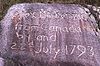 | |
| Merry Island Lighthouse | Eastern tip of Merry Island Sunrise Beach BC | 49°28′03″N 123°54′44″W / 49.4675°N 123.9122°W / 49.4675; -123.9122 (Merry Island Lighthouse) | Federal (20799) | Upload Photo | |
| George Little House | 3100 Kalum Street, Terrace Kitimat-Stikine BC | 54°30′53″N 128°35′13″W / 54.5148°N 128.587°W / 54.5148; -128.587 (George Little House) | Kitimat-Stikine municipality (15923) | Upload Photo | |
| Great War Veterans' Association Hall | 4552 Lakelse Avenue Terrace BC | 54°30′59″N 128°35′09″W / 54.5164°N 128.5858°W / 54.5164; -128.5858 (Great War Veterans' Association Hall) | Terrace municipality (21053) | Upload Photo | |
| Kitsumgallum Pioneer Cemetery | 101 Kalum Lake Drive Terrace BC | 54°31′18″N 128°38′14″W / 54.5218°N 128.6371°W / 54.5218; -128.6371 (Kitsumgallum Pioneer Cemetery) | Terrace municipality (21055) | Upload Photo | |
| Terrace Heritage Park Museum | 4702 Kerby Avenue Terrace BC | 54°32′04″N 128°35′32″W / 54.5345°N 128.5923°W / 54.5345; -128.5923 (Terrace Heritage Park Museum) | Terrace municipality (21054) | Upload Photo | |
| British Columbia Provincial Police Station | 3224 Kalum Street, Terrace Kitimat-Stikine BC | 54°31′00″N 128°35′10″W / 54.5167°N 128.586°W / 54.5167; -128.586 (British Columbia Provincial Police Station) | Kitimat-Stikine municipality (16164) | Upload Photo | |
| Kwinitsa Railway Foreman's Residence | 4805 Highway 16 West, Terrace Kitimat-Stikine BC | 54°30′56″N 128°36′00″W / 54.5155°N 128.6°W / 54.5155; -128.6 (Kwinitsa Railway Foreman's Residence) | Kitimat-Stikine municipality (16185) | Upload Photo | |
| Telegraph Creek | Telegraph Creek Kitimat-Stikine BC | 57°54′06″N 131°09′54″W / 57.9018°N 131.165°W / 57.9018; -131.165 (Telegraph Creek) | Kitimat-Stikine municipality (17922) | Upload Photo |
References
- (references appear in the table above as external links)
- v
- t
- e
- CRHP
- Alberni-Clayoquot RD
- BC Coast
- Capital RD
- Kootenay RD
- Columbia-Shuswap RD
- Comox Valley RD
- Cowichan Valley RD
- East Kootenay RD
- Fraser Valley RD
- Kootenay Boundary RD
- Nanaimo RD
- New Westminster
- North Okanagan RD
- North Shore
- Northern/Central BC Interior
- Okanagan-Similkameen RD
- Squamish-Lillooet RD
- Strathcona RD
- Surrey
- Thompson-Nicola RD
- Vancouver
- Victoria
| |||||
| |||||||
| |||||
| |||||
Wildlife Management Areas | |
|---|---|
|
Other | |
|---|---|
|
 Category
- BC Parks
 Commons


