List of historic places in Halifax, Nova Scotia
This article is a list of historic places in Halifax, Nova Scotia listed on the Canadian Register of Historic Places, all of which are designated as historic places either locally, provincially, federally or by more than one level of government. References to municipalities in the chart are to communities located within Halifax.
For historic places located elsewhere in Nova Scotia, see the List of historic places in Nova Scotia.
Map all coordinates using OpenStreetMap
Download coordinates as:
- KML
- GPX (all coordinates)
- GPX (primary coordinates)
- GPX (secondary coordinates)
List of historic places
| Name | Address | Coordinates | Government recognition (CRHP №) | Image | |
|---|---|---|---|---|---|
| Admiral's House | 770 Young Avenue Halifax NS | 44°37′48″N 63°34′26″W / 44.63°N 63.574°W / 44.63; -63.574 (Admiral's House) | Federal (4756) |  More images | |
| Admiralty House National Historic Site of Canada | 20 CFB Stadacona (2725 Gottingen St. at CFB Halifax) Halifax NS | 44°39′28″N 63°35′29″W / 44.6578°N 63.5915°W / 44.6578; -63.5915 (Admiralty House National Historic Site of Canada) | Federal (2629, (15292) |  | |
| Alexander Lawlor House | 38 King Street Dartmouth NS | 44°39′55″N 63°33′58″W / 44.6654°N 63.5662°W / 44.6654; -63.5662 (Alexander Lawlor House) | Dartmouth municipality (4124) |  More images | |
| Lorne Terrace | Building S-52 CFB Stadacona Halifax NS | 44°39′32″N 63°35′24″W / 44.6589°N 63.5901°W / 44.6589; -63.5901 (Lorne Terrace) | Federal (9501) |  | |
| Alexander James House (Evergreen House) | 26 Newcastle Street Dartmouth NS | 44°40′00″N 63°33′36″W / 44.6666°N 63.56°W / 44.6666; -63.56 (Alexander James House (Evergreen House)) | Dartmouth municipality (3075) |  More images | |
| Anderson House | 2519-2523 Brunswick Street Halifax NS | 44°39′27″N 63°35′18″W / 44.6574°N 63.5882°W / 44.6574; -63.5882 (Anderson House) | Halifax municipality (2473) |  | |
| Honourable William Annand House | 1226 Hollis Street Halifax NS | 44°38′27″N 63°34′10″W / 44.6408°N 63.5694°W / 44.6408; -63.5694 (Honourable William Annand House) | Halifax municipality (4236) |  | |
| Art Gallery of Nova Scotia | 1741 Hollis Street Halifax NS | 44°38′55″N 63°34′22″W / 44.6485°N 63.5729°W / 44.6485; -63.5729 (Art Gallery of Nova Scotia) | Federal (14222), Nova Scotia (2853), Halifax municipality (1682) |  More images | |
| Dominion Public Building | 1713 Bedford Row Halifax NS | 44°38′54″N 63°34′20″W / 44.6483°N 63.5721°W / 44.6483; -63.5721 (Dominion Public Building) | Federal (4336) |  | |
| Battery and Magazine | Shore Road and Purcell's Cove Road Halifax NS | 44°35′43″N 63°33′14″W / 44.5952°N 63.5539°W / 44.5952; -63.5539 (Battery and Magazine) | Federal (2015) |  | |
| Battery Command Post | Highest point of Fort McNab Halifax NS | 44°36′01″N 63°30′51″W / 44.6002°N 63.5141°W / 44.6002; -63.5141 (Battery Command Post) | Federal (9741) |  Upload Photo | |
| Building 1 | Royal Artillery Park Halifax NS | 44°38′41″N 63°34′40″W / 44.6446°N 63.5779°W / 44.6446; -63.5779 (Building 1) | Federal (11276) | Upload Photo | |
| Building No. 4 | 9 Grove Street, Nivens Avenue, French Cable Wharf, DREA Dartmouth NS | 44°40′16″N 63°35′28″W / 44.671°N 63.591°W / 44.671; -63.591 (Building No. 4) | Federal (7843) | Upload Photo | |
| Caldwell House | 1714 Robie Street Halifax NS | 44°38′38″N 63°35′19″W / 44.6438°N 63.5887°W / 44.6438; -63.5887 (Caldwell House) | Nova Scotia (3138), Halifax municipality (5326) |  | |
| Cambridge Military Library | Sackville Street Halifax NS | 44°38′38″N 63°34′34″W / 44.644°N 63.576°W / 44.644; -63.576 (Cambridge Military Library) | Federal (3994) |  | |
| Carroll Building S-17 | CFB Halifax Halifax NS | 44°39′39″N 63°35′38″W / 44.6608°N 63.5938°W / 44.6608; -63.5938 (Carroll Building S-17) | Federal (9840) |  | |
| Casemates | Fort McNab Halifax NS | 44°36′00″N 63°30′55″W / 44.6°N 63.5152°W / 44.6; -63.5152 (Casemates) | Federal (11040) |  | |
| Cast Iron Façade / Coomb's Old English Shoe Store National Historic Site of Canada | 1883-1885 Granville Street Halifax NS | 44°38′57″N 63°34′28″W / 44.6492°N 63.5745°W / 44.6492; -63.5745 (Cast Iron Façade / Coomb's Old English Shoe Store National Historic Site of Canada) | Federal (1393) | 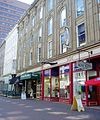 | |
| Cavalier Building | Halifax Citadel Halifax NS | 44°38′49″N 63°34′50″W / 44.647°N 63.5805°W / 44.647; -63.5805 (Cavalier Building) | Federal (2989) |  | |
| Christ Church | 50 Wentworth Street Dartmouth NS | 44°40′03″N 63°34′05″W / 44.6675°N 63.5680°W / 44.6675; -63.5680 (Christ Church) | Dartmouth municipality (4583) |  | |
| Clam Harbour Archaeological Site - BeCr-04 | Clam Harbour Provincial Park Clam Harbour NS | 44°43′N 62°52′W / 44.71°N 62.86°W / 44.71; -62.86 (Clam Harbour Archaeological Site - BeCr-04) | Nova Scotia (14895) | Upload Photo | |
| Cleverdon Building | 1709 Barrington Street Halifax NS | 44°34′28″N 63°34′26″W / 44.5745°N 63.574°W / 44.5745; -63.574 (Cleverdon Building) | Halifax municipality (1510) |  More images | |
| Cole Harbour Meeting House | 1436 Cole Harbour Road Cole Harbour NS | 44°40′21″N 63°28′12″W / 44.6725°N 63.4699°W / 44.6725; -63.4699 (Cole Harbour Meeting House) | Nova Scotia (6651) | Upload Photo | |
| Cole Harbour Farm | 471-475 Poplar Drive Dartmouth NS | 44°40′21″N 63°29′59″W / 44.6725°N 63.4997°W / 44.6725; -63.4997 (Cole Harbour Farm) | Nova Scotia (6559), Dartmouth municipality (4204) | Upload Photo | |
| Command Post | York Redoubt NHS Halifax NS | 44°35′30″N 63°33′27″W / 44.5917°N 63.5575°W / 44.5917; -63.5575 (Command Post) | Federal (6239) | Upload Photo | |
| Fire Command Post | York Redoubt NHS Halifax NS | 44°38′N 63°33′W / 44.64°N 63.55°W / 44.64; -63.55 (Fire Command Post) | Federal (3203) |  | |
| Commanding Officer's Residence | 5425 Sackville Street Halifax NS | 44°38′38″N 63°34′34″W / 44.644°N 63.576°W / 44.644; -63.576 (Commanding Officer's Residence) | Federal (11106) | Upload Photo | |
| Commander's Residence | 830 Young Avenue, CFB Halifax Halifax NS | 44°39′39″N 63°35′33″W / 44.6607°N 63.5925°W / 44.6607; -63.5925 (Commander's Residence) | Federal (4755) | Upload Photo | |
| Counterscarp Gallery | Halifax Citadel Halifax NS | 44°38′49″N 63°34′50″W / 44.647°N 63.5805°W / 44.647; -63.5805 (Counterscarp Gallery) | Federal (2991) | Upload Photo | |
| Cookhouse, Building 626 | York Redoubt NHS Halifax NS | 44°35′30″N 63°33′27″W / 44.5917°N 63.5575°W / 44.5917; -63.5575 (Cookhouse, Building 626) | Federal (4419) |  | |
| Crystal Crescent Archaeological Site, Borden Number BcCv-01 to 03 | Crystal Crescent Provincial Park Sambro Island NS | 44°27′N 63°37′W / 44.45°N 63.62°W / 44.45; -63.62 (Crystal Crescent Archaeological Site, Borden Number BcCv-01 to 03) | Nova Scotia (6514) | Upload Photo | |
| Currie Building, S37 | CFB Halifax Halifax NS | 44°39′39″N 63°35′33″W / 44.6607°N 63.5925°W / 44.6607; -63.5925 (Currie Building, S37) | Federal (9581) |  | |
| Defensive Casemates 5-6 | Halifax Citadel Halifax NS | 44°38′49″N 63°34′50″W / 44.647°N 63.5805°W / 44.647; -63.5805 (Defensive Casemates 5-6) | Federal (4395) | Upload Photo | |
| Defensive Casemates 51 and 52 | Halifax Citadel Halifax NS | 44°38′49″N 63°34′50″W / 44.647°N 63.5805°W / 44.647; -63.5805 (Defensive Casemates 51 and 52) | Federal (4406) | Upload Photo | |
| Defensive Casemates 57 and 58 | Halifax Citadel Halifax NS | 44°38′49″N 63°34′50″W / 44.647°N 63.5805°W / 44.647; -63.5805 (Defensive Casemates 57 and 58) | Federal (4407) | Upload Photo | |
| Dingle Tower | 260 Dingle Road Halifax NS | 44°37′49″N 63°35′50″W / 44.6302°N 63.59735°W / 44.6302; -63.59735 (Dingle Tower) | Federal (12262), Halifax municipality (2447) |  More images | |
| Dingle Tower and Sir Sanford Fleming Park | 260 Dingle Road Halifax NS | 44°37′49″N 63°35′50″W / 44.6302°N 63.5972°W / 44.6302; -63.5972 (Dingle Tower and Sir Sanford Fleming Park) | Halifax municipality (3079) |  More images | |
| Dockyard Terrace | Buildings 77, 78 and 79 HMC Dockyard Terrace Halifax NS | 44°39′27″N 63°34′54″W / 44.6574°N 63.5818°W / 44.6574; -63.5818 (Dockyard Terrace) | Federal (11261) |  | |
| Elledge McElmon House | 52 King Street Dartmouth NS | 44°39′57″N 63°34′00″W / 44.6659°N 63.5668°W / 44.6659; -63.5668 (Elledge McElmon House) | Dartmouth municipality (4135) |  More images | |
| Elsie Hume House | 8502 No. 3 Highway Black Point NS | 44°39′12″N 63°59′00″W / 44.6532°N 63.9832°W / 44.6532; -63.9832 (Elsie Hume House) | Nova Scotia (7823) | Upload Photo | |
| Former Artillery Stores, Building 91 | Fort Charlotte, Georges Island Halifax NS | 44°38′28″N 63°33′33″W / 44.6412°N 63.5592°W / 44.6412; -63.5592 (Former Artillery Stores, Building 91) | Federal (4413) | Upload Photo | |
| Former Artillery Stores, Building 629 | York Redoubt NHS Halifax NS | 44°35′30″N 63°33′27″W / 44.5917°N 63.5575°W / 44.5917; -63.5575 (Former Artillery Stores, Building 629) | Federal (4405) |  | |
| Former Field Forge Storage Building No. 90 | Fort Charlotte, Georges Island Halifax NS | 44°38′28″N 63°33′34″W / 44.6412°N 63.5594°W / 44.6412; -63.5594 (Former Field Forge Storage Building No. 90) | Federal (4414) | Upload Photo | |
| Former Guardhouse / Fire Engine House / Coal Stores, Building 114 | Fort Charlotte, Georges Island Halifax NS | 44°38′28″N 63°33′34″W / 44.6411°N 63.5594°W / 44.6411; -63.5594 (Former Guardhouse / Fire Engine House / Coal Stores, Building 114) | Federal (4418) | Upload Photo | |
| Former Guardroom and Prisoners' Quarters | Fort Charlotte, Georges Island Halifax NS | 44°38′28″N 63°33′33″W / 44.6412°N 63.5591°W / 44.6412; -63.5591 (Former Guardroom and Prisoners' Quarters) | Federal (4415) | Upload Photo | |
| Former Hampton Gray Memorial School, Building 14 | CFB Shearwater Halifax NS | 44°38′17″N 63°29′53″W / 44.638°N 63.498°W / 44.638; -63.498 (Former Hampton Gray Memorial School, Building 14) | Federal (4227) | Upload Photo | |
| Former Stores Building 110 (Carpenter Shop and Smithy) | Georges Island Halifax NS | 44°38′28″N 63°33′32″W / 44.641°N 63.559°W / 44.641; -63.559 (Former Stores Building 110 (Carpenter Shop and Smithy)) | Federal (2831) | Upload Photo | |
| Fort McNab National Historic Site of Canada | McNabs Island Halifax NS | 44°36′06″N 63°30′54″W / 44.6016°N 63.5149°W / 44.6016; -63.5149 (Fort McNab National Historic Site of Canada) | Federal (15810) |  | |
| Fultz House | 33 Sackville Drive Lower Sackville NS | 44°45′10″N 63°39′54″W / 44.7528°N 63.6649°W / 44.7528; -63.6649 (Fultz House) | Lower Sackville municipality (7120) |  | |
| Gas House | Sambro Island NS | 44°28′N 63°35′W / 44.47°N 63.59°W / 44.47; -63.59 (Gas House) | Federal (4426) |  | |
| Georges Island National Historic Site of Canada | Georges Island Halifax NS | 44°38′29″N 63°33′33″W / 44.6413°N 63.5593°W / 44.6413; -63.5593 (Georges Island National Historic Site of Canada) | Federal (7619) |  More images | |
| Government House National Historic Site of Canada | 1451 Barrington Street Halifax NS | 44°38′35″N 63°34′19″W / 44.6431°N 63.5719°W / 44.6431; -63.5719 (Government House National Historic Site of Canada) | Federal (12641), Nova Scotia (2161) |  | |
| Grace Hiltz House | 47 Wentworth Street Dartmouth NS | 44°40′03″N 63°34′06″W / 44.6674°N 63.5682°W / 44.6674; -63.5682 (Grace Hiltz House) | Dartmouth municipality (3080) |  More images | |
| Greenvale School | 130 Ochterloney Street Dartmouth NS | 44°40′09″N 63°33′54″W / 44.6692°N 63.5649°W / 44.6692; -63.5649 (Greenvale School) | Dartmouth municipality (3366) |  More images | |
| Gun Emplacement, Magazine and Crew Shelter 2 | Fort McNab Halifax NS | 44°36′01″N 63°30′53″W / 44.6002°N 63.5147°W / 44.6002; -63.5147 (Gun Emplacement, Magazine and Crew Shelter 2) | Federal (9920) | Upload Photo | |
| Gun Emplacement, Magazine and Crew Shelter 1 | Fort McNab Halifax NS | 44°36′01″N 63°30′58″W / 44.6004°N 63.516°W / 44.6004; -63.516 (Gun Emplacement, Magazine and Crew Shelter 1) | Federal (9921) | | |
| Gun Emplacements 3 and 4, Radar Building, Left Magazine and Crew Shelter | Fort McNab Halifax NS | 44°35′59″N 63°30′52″W / 44.5996°N 63.5145°W / 44.5996; -63.5145 (Gun Emplacements 3 and 4, Radar Building, Left Magazine and Crew Shelter) | Federal (9955) | Upload Photo | |
| Halifax Citadel National Historic Site of Canada | 5161 George Street Halifax NS | 44°38′50″N 63°34′49″W / 44.6473°N 63.5804°W / 44.6473; -63.5804 (Halifax Citadel National Historic Site of Canada) | Federal (7622) |  More images | |
| Halifax Court House National Historic Site of Canada | 5250 Spring Garden Road Halifax NS | 44°38′37″N 63°34′26″W / 44.6436°N 63.5738°W / 44.6436; -63.5738 (Halifax Court House National Historic Site of Canada) | Federal (12832), Nova Scotia (1677) | 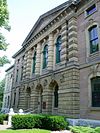 | |
| Halifax Defense Complex, Georges Island, Fort Charlotte, South, Southeast and Southwest Caponiers | Fort Charlotte, Georges Island Halifax NS | 44°38′28″N 63°33′34″W / 44.6412°N 63.5594°W / 44.6412; -63.5594 (Halifax Defense Complex, Georges Island, Fort Charlotte, South, Southeast and Southwest Caponiers) | Federal (4417) | Upload Photo | |
| Halifax Dockyard National Historic Site of Canada | Barrington and Upper Water Streets Halifax NS | 44°39′32″N 63°35′02″W / 44.6588°N 63.5838°W / 44.6588; -63.5838 (Halifax Dockyard National Historic Site of Canada) | Federal (16146) |  | |
| Halifax Public Gardens National Historic Site of Canada | Spring Garden Road Halifax NS | 44°38′34″N 63°34′49″W / 44.6428°N 63.5803°W / 44.6428; -63.5803 (Halifax Public Gardens National Historic Site of Canada) | Federal (2633), Halifax municipality (3221) |  More images | |
| Halifax Waterfront Buildings National Historic Site of Canada | Upper Water Street Halifax NS | 44°39′01″N 63°34′24″W / 44.6502°N 63.5733°W / 44.6502; -63.5733 (Halifax Waterfront Buildings National Historic Site of Canada) | Federal (1614), Halifax municipality (1536) |  | |
| Henry House | 1222 Barrington Street Halifax NS | 44°38′25″N 63°34′15″W / 44.6404°N 63.5708°W / 44.6404; -63.5708 (Henry House) | Federal (12665), Nova Scotia (4490), Halifax municipality (3383) |  More images | |
| Henry Elliot House | 99 Ochterloney Street Dartmouth NS | 44°40′06″N 63°34′00″W / 44.6682°N 63.5667°W / 44.6682; -63.5667 (Henry Elliot House) | Dartmouth municipality (7119) |  More images | |
| James Austin House | 287 Portland Street Dartmouth NS | 44°40′09″N 63°33′23″W / 44.6692°N 63.5565°W / 44.6692; -63.5565 (James Austin House) | Dartmouth municipality (3467) |  More images | |
| James McKenzie House | 5675 North Street Halifax NS | 44°39′21″N 63°35′36″W / 44.6558°N 63.5932°W / 44.6558; -63.5932 (James McKenzie House) | Halifax municipality (7092) |  | |
| James Orman House | 34 King Street Dartmouth NS | 44°39′55″N 63°33′57″W / 44.6653°N 63.5659°W / 44.6653; -63.5659 (James Orman House) | Dartmouth municipality (4878) |  More images | |
| James Simmonds House | 51-53 Pleasant Street Dartmouth NS | 44°40′06″N 63°33′33″W / 44.6682°N 63.5591°W / 44.6682; -63.5591 (James Simmonds House) | Dartmouth municipality (5325) |  More images | |
| John Salisbury House | 42 Summit Street Dartmouth NS | 44°40′12″N 63°33′20″W / 44.67°N 63.5555°W / 44.67; -63.5555 (John Salisbury House) | Dartmouth municipality (4770) |  | |
| Johnstone Chittick House | 149 Prince Albert Road Dartmouth NS | 44°40′27″N 63°33′37″W / 44.6742°N 63.5604°W / 44.6742; -63.5604 (Johnstone Chittick House) | Dartmouth municipality (3853) |  | |
| Joseph Howe Austen House | 37 Pleasant Street Dartmouth NS | 44°40′07″N 63°33′37″W / 44.6687°N 63.5604°W / 44.6687; -63.5604 (Joseph Howe Austen House) | Dartmouth municipality (3712) |  More images | |
| Laboratory, former Building 92 | Fort Charlotte, Georges Island Halifax NS | 44°38′29″N 63°33′35″W / 44.6413°N 63.5596°W / 44.6413; -63.5596 (Laboratory, former Building 92) | Federal (4412) | Upload Photo | |
| Lighthouse | Entrance to St. Margaret's Bay Peggys Cove NS | 44°29′28″N 63°55′08″W / 44.491°N 63.919°W / 44.491; -63.919 (Lighthouse (Peggy's Point)) | Federal (2921) |  More images | |
| Terence Bay Lighthouse | Sandy Cove Road Terence Bay NS | 44°27′36″N 63°42′20″W / 44.4601°N 63.7056°W / 44.4601; -63.7056 (Terence Bay Lighthouse) | Federal (20721) |  | |
| Lower Battery | Fort Charlotte, Georges Island Halifax NS | 44°38′N 63°33′W / 44.64°N 63.55°W / 44.64; -63.55 (Lower Battery) | Federal (3163) | Upload Photo | |
| Main Magazine, Building 611 | York Redoubt NHS Halifax NS | 44°35′45″N 63°33′20″W / 44.5958°N 63.5556°W / 44.5958; -63.5556 (Main Magazine, Building 611) | Federal (4420) |  | |
| Main Magazine and Tunnel Complex, Building 89 Classified Federal Heritage Building | Fort Charlotte, Georges Island Halifax NS | 44°38′27″N 63°33′32″W / 44.6407°N 63.5590°W / 44.6407; -63.5590 (Main Magazine and Tunnel Complex, Building 89 Classified Federal Heritage Building) | Federal (3164) | Upload Photo | |
| Married Officers Quarters, former Building 125 Recognized Federal Heritage Building | Georges Island Halifax NS | 44°38′28″N 63°33′32″W / 44.641°N 63.559°W / 44.641; -63.559 (Married Officers Quarters, former Building 125 Recognized Federal Heritage Building) | Federal (2830) | Upload Photo | |
| Mary Queen of Scots House | 1266 Queen Street Halifax NS | 44°38′25″N 63°34′29″W / 44.6403°N 63.5747°W / 44.6403; -63.5747 (Mary Queen of Scots House) | Halifax municipality (6751) |  | |
| Maugher's Beach Light Tower | McNabs Island Halifax NS | 44°36′08″N 63°32′01″W / 44.6023°N 63.5336°W / 44.6023; -63.5336 (Maugher's Beach Light Tower) | Federal (16003) |  | |
| Moirs Ltd. Power House | 926 Bedford Highway Bedford NS | 44°42′51″N 63°40′41″W / 44.7141°N 63.678°W / 44.7141; -63.678 (Moirs Ltd. Power House) | Nova Scotia (2755), Bedford municipality (3150) |  | |
| Murray Building (S-15) | CFB Halifax Halifax NS | 44°39′39″N 63°35′33″W / 44.6607°N 63.5925°W / 44.6607; -63.5925 (Murray Building (S-15)) | Federal (9518) |  | |
| Mystery House | 95 King Street Dartmouth NS | 44°40′02″N 63°34′11″W / 44.6671°N 63.5696°W / 44.6671; -63.5696 (Mystery House) | Dartmouth municipality (3482) |  | |
| North Caponiers, Building 82A & 82B | Fort Charlotte, Georges Island Halifax NS | 44°38′28″N 63°33′34″W / 44.6412°N 63.5594°W / 44.6412; -63.5594 (North Caponiers, Building 82A & 82B) | Federal (4416) | Upload Photo | |
| North Expense Magazine | Halifax Citadel Halifax NS | 44°38′49″N 63°34′50″W / 44.647°N 63.5805°W / 44.647; -63.5805 (North Expense Magazine) | Federal (4408) | Upload Photo | |
| Northeast Salient | Halifax Citadel Halifax NS | 44°38′49″N 63°34′50″W / 44.647°N 63.5805°W / 44.647; -63.5805 (Northeast Salient) | Federal (4409) | Upload Photo | |
| Officers' Married Quarters | 5425 Sackville Street Halifax NS | 44°38′38″N 63°34′37″W / 44.644°N 63.577°W / 44.644; -63.577 (Officers' Married Quarters) | Federal (11111) | Upload Photo | |
| Oil Stores and Artificers Shop | Fort McNab Halifax NS | 44°36′02″N 63°30′54″W / 44.6005°N 63.515°W / 44.6005; -63.515 (Oil Stores and Artificers Shop) | Federal (9952) | Upload Photo | |
| Old Burying Ground National Historic Site of Canada | 1460 Barrington Street Halifax NS | 44°38′36″N 63°34′22″W / 44.6433°N 63.5729°W / 44.6433; -63.5729 (Old Burying Ground National Historic Site of Canada) | Federal (9982), Nova Scotia (6787) |  More images | |
| Owl Drug Store | 71 Portland Street Dartmouth NS | 44°39′57″N 63°34′00″W / 44.6657°N 63.5667°W / 44.6657; -63.5667 (Owl Drug Store) | Dartmouth municipality (3355) |  | |
| Pier 21 National Historic Site of Canada | 1055 Marginal Road Halifax NS | 44°38′18″N 63°33′56″W / 44.6383°N 63.5655°W / 44.6383; -63.5655 (Pier 21 National Historic Site of Canada) | Federal (7648) |  More images | |
| Prince of Wales Tower National Historic Site of Canada | Tower Road Halifax NS | 44°37′17″N 63°34′11″W / 44.6215°N 63.5697°W / 44.6215; -63.5697 (Prince of Wales Tower National Historic Site of Canada) | Federal (7471, (3175) |  More images | |
| Quaker House | 57-59 Ochterloney Street Dartmouth NS | 44°40′01″N 63°34′06″W / 44.667°N 63.5682°W / 44.667; -63.5682 (Quaker House) | Nova Scotia (2577), Dartmouth municipality (3066) |  More images | |
| Ralston Building | 1557 Hollis Street Halifax NS | 44°38′45″N 63°34′17″W / 44.6457°N 63.5713°W / 44.6457; -63.5713 (Ralston Building) | Federal (9515) | Upload Photo | |
| Range Finder Bunker | York Redoubt NHS Halifax NS | 44°35′32″N 63°33′00″W / 44.5921°N 63.5501°W / 44.5921; -63.5501 (Range Finder Bunker) | Federal (11658) |  | |
| Redan | Halifax Citadel Halifax NS | 44°38′49″N 63°34′50″W / 44.647°N 63.5805°W / 44.647; -63.5805 (Redan) | Federal (2996) | Upload Photo | |
| Robert Innes House | 7 Newcastle Street Dartmouth NS | 44°40′02″N 63°33′40″W / 44.6672°N 63.561°W / 44.6672; -63.561 (Robert Innes House) | Dartmouth municipality (3624) |  More images | |
| St. John's Anglican Church | 8 Church Road Peggys Cove NS | 44°29′42″N 63°54′56″W / 44.495°N 63.9156°W / 44.495; -63.9156 (St. John's Anglican Church) | Peggys Cove municipality (3320) |  | |
| St. Mary's Basilica National Historic Site of Canada | 1508 Barrington St. (at Spring Garden Rd.) Halifax NS | 44°38′39″N 63°34′24″W / 44.6443°N 63.5732°W / 44.6443; -63.5732 (St. Mary's Basilica National Historic Site of Canada) | Federal (12131) |  | |
| St. Patrick's Roman Catholic Church | 2263 Brunswick Street Halifax NS | 44°39′15″N 63°34′58″W / 44.6542°N 63.5829°W / 44.6542; -63.5829 (St. Patrick's Roman Catholic Church) | Nova Scotia (15335) |  | |
| St. Paul's Anglican Church | 71 St. Paul's Lane French Village NS | 44°37′38″N 63°55′26″W / 44.6271°N 63.9239°W / 44.6271; -63.9239 (St. Paul's Anglican Church) | French Village municipality (8045) | Upload Photo | |
| Samuel Greenwood House | 63 King Street Dartmouth NS | 44°39′58″N 63°34′04″W / 44.666°N 63.5678°W / 44.666; -63.5678 (Samuel Greenwood House) | Dartmouth municipality (4123) |  More images | |
| Scott Manor House | 15 Fort Sackville Road Bedford NS | 44°43′45″N 63°39′36″W / 44.7293°N 63.6601°W / 44.7293; -63.6601 (Scott Manor House) | Nova Scotia (2987), Bedford municipality (3143) |  | |
| Searchlights 690, 691, 692 | York Redoubt NHS Halifax NS | 44°35′30″N 63°33′27″W / 44.5917°N 63.5575°W / 44.5917; -63.5575 (Searchlights 690, 691, 692) | Federal (4404) |  | |
| Searchlight Emplacement Building 6 | McNab's Island Halifax NS | 44°35′45″N 63°30′42″W / 44.5958°N 63.5117°W / 44.5958; -63.5117 (Searchlight Emplacement Building 6) | Federal (10396) |  | |
| Sir Sandford Fleming Barn | 30-32 Dingle Road Halifax NS | 44°37′49″N 63°35′50″W / 44.6302°N 63.5973°W / 44.6302; -63.5973 (Sir Sandford Fleming Barn) | Nova Scotia (2451), Halifax municipality (9372) | Upload Photo | |
| Sir Sandford Fleming Cottage | 30 Dingle Road Halifax NS | 44°37′52″N 63°36′11″W / 44.631°N 63.603°W / 44.631; -63.603 (Sir Sandford Fleming Cottage) | Nova Scotia (3848), Halifax municipality (2455) | Upload Photo | |
| South Caponier | York Redoubt NHS Halifax NS | 44°35′30″N 63°33′27″W / 44.5917°N 63.5575°W / 44.5917; -63.5575 (South Caponier) | Federal (4421) |  | |
| South Expense Magazine | Halifax Citadel Halifax NS | 44°38′49″N 63°34′50″W / 44.647°N 63.5805°W / 44.647; -63.5805 (South Expense Magazine) | Federal (4425) | Upload Photo | |
| Southeast Salient | Halifax Citadel Halifax NS | 44°38′N 63°35′W / 44.64°N 63.58°W / 44.64; -63.58 (Southeast Salient) | Federal (3173) | Upload Photo | |
| Sterns' Corner | 81 Alderney Drive Dartmouth NS | 44°39′52″N 63°34′06″W / 44.6645°N 63.5682°W / 44.6645; -63.5682 (Sterns' Corner) | Dartmouth municipality (3859) |  | |
| The Teachery | 9 Spring Street Bedford NS | 44°43′38″N 63°40′00″W / 44.7273°N 63.6667°W / 44.7273; -63.6667 (The Teachery) | Bedford municipality (3381) | Upload Photo | |
| Thomas Boggs-Lawrence Hartshorne House | 53 Ochterloney Street Dartmouth NS | 44°40′00″N 63°34′07″W / 44.6668°N 63.5685°W / 44.6668; -63.5685 (Thomas Boggs-Lawrence Hartshorne House) | Dartmouth municipality (3424) |  More images | |
| Thurso House | 289 Portland Street Dartmouth NS | 44°40′09″N 63°33′23″W / 44.6691°N 63.5564°W / 44.6691; -63.5564 (Thurso House) | Dartmouth municipality (5085) |  More images | |
| Town Clock on Citadel Hill | Brunswick Street Halifax NS | 44°38′51″N 63°34′39″W / 44.6474°N 63.5776°W / 44.6474; -63.5776 (Town Clock on Citadel Hill) | Federal (4260) |  More images | |
| Van Steenburgh and Polaris Buildings at The Bedford Institute of Oceanography | Baffin Boulevard Dartmouth NS | 44°40′58″N 63°36′41″W / 44.6829°N 63.6113°W / 44.6829; -63.6113 (Van Steenburgh and Polaris Buildings at The Bedford Institute of Oceanography) | Federal (4261) | Upload Photo | |
| Victoria Road United Baptist Church | 36 Victoria Road Dartmouth NS | 44°40′09″N 63°34′01″W / 44.6691°N 63.567°W / 44.6691; -63.567 (Victoria Road United Baptist Church) | Dartmouth municipality (3852) |  More images | |
| Wellington House | Building S12, Barrington Street (CFB Halifax) Halifax NS | 44°39′42″N 63°35′37″W / 44.6618°N 63.5937°W / 44.6618; -63.5937 (Wellington House) | Federal (16584) |  | |
| West Ravelin Guardhouse | Halifax Citadel Halifax NS | 44°38′49″N 63°34′50″W / 44.647°N 63.5805°W / 44.647; -63.5805 (West Ravelin Guardhouse) | Federal (4410) | Upload Photo | |
| West Curtain Wall | Halifax Citadel Halifax NS | 44°38′49″N 63°34′50″W / 44.647°N 63.5805°W / 44.647; -63.5805 (West Curtain Wall) | Federal (4411) | Upload Photo | |
| William Black Memorial United Church | 10515 Peggy's Cove Road; No. 333 Highway Glen Margaret NS | 44°35′11″N 63°54′55″W / 44.5864°N 63.9154°W / 44.5864; -63.9154 (William Black Memorial United Church) | Nova Scotia (9465) | Upload Photo | |
| William Walker House | 119 Prince Albert Road Dartmouth NS | 44°40′21″N 63°33′44″W / 44.6726°N 63.5621°W / 44.6726; -63.5621 (William Walker House) | Dartmouth municipality (3566) |  | |
| York Manuel Fish Shed and Store | 32 Lobster Lane Peggys Cove NS | 44°29′37″N 63°54′58″W / 44.4936°N 63.9161°W / 44.4936; -63.9161 (York Manuel Fish Shed and Store) | Nova Scotia (14684) |  More images | |
| York Redoubt National Historic Site of Canada | Shore Road and Purcell's Cove Road Halifax NS | 44°35′43″N 63°33′14″W / 44.5952°N 63.5539°W / 44.5952; -63.5539 (York Redoubt National Historic Site of Canada) | Federal (7746) |  More images | |
| Leadley House | 47 North Street Dartmouth NS | 44°40′05″N 63°34′07″W / 44.668°N 63.5685°W / 44.668; -63.5685 (Leadley House) | Dartmouth municipality (6718) |  | |
| Charles A. Robson House | 64 Queen Street Dartmouth NS | 44°40′02″N 63°33′58″W / 44.6671°N 63.5661°W / 44.6671; -63.5661 (Charles A. Robson House) | Dartmouth municipality (7252) |  More images | |
| James-Robson House | 62 Queen Street Dartmouth NS | 44°40′01″N 63°33′58″W / 44.667°N 63.5662°W / 44.667; -63.5662 (James-Robson House) | Dartmouth municipality (7253) |  More images | |
| Wesley Forbes House | 41 Pleasant Street Dartmouth NS | 44°40′07″N 63°33′37″W / 44.6686°N 63.5602°W / 44.6686; -63.5602 (Wesley Forbes House) | Dartmouth municipality (7254) |  More images | |
| 90-92 Ochterloney Street | 90-92 Ochterloney Street Dartmouth NS | 44°40′04″N 63°34′01″W / 44.6679°N 63.5669°W / 44.6679; -63.5669 (90-92 Ochterloney Street) | Dartmouth municipality (10385) |  More images | |
| Oakwood House | 88A Crichton Avenue Dartmouth NS | 44°40′34″N 63°33′46″W / 44.676°N 63.5628°W / 44.676; -63.5628 (Oakwood House) | Dartmouth municipality (3354) |  | |
| 70 Victoria Road | 70 Victoria Road Dartmouth NS | 44°40′14″N 63°34′11″W / 44.6706°N 63.5698°W / 44.6706; -63.5698 (70 Victoria Road) | Dartmouth municipality (8074) |  | |
| Local Council of Women of Halifax House | 989 Young Ave Halifax NS | 44°38′03″N 63°34′32″W / 44.6343°N 63.5755°W / 44.6343; -63.5755 (Local Council of Women of Halifax House) | Halifax municipality (3109) |  | |
| South Magazine and Shifting Room Classified Federal Heritage Building | Halifax Citadel Halifax NS | 44°38′59″N 63°34′46″W / 44.6496°N 63.5795°W / 44.6496; -63.5795 (South Magazine and Shifting Room Classified Federal Heritage Building) | Federal (3169) | | |
| Bengal Lancers Property | 1690 Bell Road Halifax NS | 44°38′43″N 63°35′00″W / 44.6454°N 63.5834°W / 44.6454; -63.5834 (Bengal Lancers Property) | Halifax municipality (3316) |  More images | |
| Thorndean | 5680 Inglis Street Halifax NS | 44°38′03″N 63°34′31″W / 44.6343°N 63.5752°W / 44.6343; -63.5752 (Thorndean) | Nova Scotia (7288), Halifax municipality (3380) |  More images | |
| Carlton Victorian Streetscape | 1452-1489 Carlton Street Halifax NS | 44°38′25″N 63°35′05″W / 44.6402°N 63.5848°W / 44.6402; -63.5848 (Carlton Victorian Streetscape) | Halifax municipality (3584) | Upload Photo | |
| James Rose House | 6201 Shirley Street Halifax NS | 44°38′41″N 63°35′43″W / 44.6446°N 63.5953°W / 44.6446; -63.5953 (James Rose House) | Halifax municipality (3824) |  More images | |
| Smith Victorian Streetscape | 5214-5250 Smith Street Halifax NS | 44°38′12″N 63°34′14″W / 44.6367°N 63.5705°W / 44.6367; -63.5705 (Smith Victorian Streetscape) | Halifax municipality (3851) |  | |
| Tower Victorian Streetscape | 1041-1105 Tower Road Halifax NS | 44°38′07″N 63°34′41″W / 44.6354°N 63.578°W / 44.6354; -63.578 (Tower Victorian Streetscape) | Halifax municipality (4011) |  More images | |
| 5651 - 5691 Inglis Street | 5651-5691 Inglis Street Halifax NS | 44°38′05″N 63°34′31″W / 44.6346°N 63.5752°W / 44.6346; -63.5752 (5651 - 5691 Inglis Street) | Federal (3953) |  | |
| 5721 - 5765 Inglis Street | 5721-5765 Inglis Street Halifax NS | 44°38′03″N 63°34′38″W / 44.6343°N 63.5772°W / 44.6343; -63.5772 (5721 - 5765 Inglis Street) | Halifax municipality (4117) |  More images | |
| Oakland Lodge | 1124 Robie Street Halifax NS | 44°38′06″N 63°35′05″W / 44.635°N 63.5847°W / 44.635; -63.5847 (Oakland Lodge) | Halifax municipality (4138) |  More images | |
| Senator William Dennis House | 1731 Rosebank Avenue; 6503 Jubilee Road Halifax NS | 44°38′26″N 63°36′04″W / 44.6405°N 63.6012°W / 44.6405; -63.6012 (Senator William Dennis House) | Halifax municipality (4923) |  | |
| The Bower | 5918 Rogers Drive Halifax NS | 44°37′43″N 63°34′46″W / 44.6286°N 63.5795°W / 44.6286; -63.5795 (The Bower) | Nova Scotia (5224), Halifax municipality (6849) |  More images | |
| Universalist Unitarian Church of Halifax | 5500 Inglis Street Halifax NS | 44°38′06″N 63°34′22″W / 44.6349°N 63.5729°W / 44.6349; -63.5729 (Universalist Unitarian Church of Halifax) | Nova Scotia (5768) | 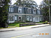 More images | |
| Wright Building | 1672-74 Barrington Street Halifax NS | 44°38′49″N 63°34′26″W / 44.6470°N 63.5740°W / 44.6470; -63.5740 (Wright Building) | Halifax municipality (10700) |  | |
| George Wright House | 989 Young Avenue Halifax NS | 44°38′03″N 63°34′32″W / 44.6343°N 63.5755°W / 44.6343; -63.5755 (George Wright House) | Nova Scotia (7324) |  | |
| Fernwood National Historic Site of Canada | 700 Franklyn Street Halifax NS | 44°37′34″N 63°34′40″W / 44.626°N 63.5779°W / 44.626; -63.5779 (Fernwood National Historic Site of Canada) | Federal (7603) |  More images | |
| Fort Massey United Church | 1181 Queen Street Halifax NS | 44°38′20″N 63°34′24″W / 44.6389°N 63.5733°W / 44.6389; -63.5733 (Fort Massey United Church) | Nova Scotia (7704) |  | |
| 1606 Bell Road | 1606 Bell Road Halifax NS | 44°38′41″N 63°34′52″W / 44.6447°N 63.5811°W / 44.6447; -63.5811 (1606 Bell Road) | Halifax municipality (10631) |  | |
| Former City Club | 1580 Barrington Street Halifax NS | 44°38′45″N 63°34′25″W / 44.6457°N 63.5735°W / 44.6457; -63.5735 (Former City Club) | Halifax municipality (1390) |  | |
| Sievert's Tobacco Building | 1573 Barrington Street Halifax NS | 44°38′45″N 63°34′23″W / 44.6457°N 63.5731°W / 44.6457; -63.5731 (Sievert's Tobacco Building) | Halifax municipality (1392) |  | |
| Colwell Building | 1673 Barrington Street Halifax NS | 44°38′49″N 63°34′25″W / 44.6469°N 63.5737°W / 44.6469; -63.5737 (Colwell Building) | Halifax municipality (1507) |  | |
| Shaw Building | 1855-1859 Hollis Street Halifax NS | 44°38′59″N 63°34′25″W / 44.6497°N 63.5737°W / 44.6497; -63.5737 (Shaw Building) | Halifax municipality (1534) |  | |
| Former Church of England Institute | 1588 Barrington Street Halifax NS | 44°38′45″N 63°34′25″W / 44.6459°N 63.5735°W / 44.6459; -63.5735 (Former Church of England Institute) | Halifax municipality (2369) |  | |
| Macara-Barnstead Building | 1796-1798 Granville Street Halifax NS | 44°38′56″N 63°34′27″W / 44.6488°N 63.5742°W / 44.6488; -63.5742 (Macara-Barnstead Building) | Halifax municipality (2459) |  | |
| St. Paul's Church (Halifax) National Historic Site of Canada | 1747 Argyle Street; 1 St. Paul's Hill Halifax NS | 44°38′51″N 63°34′28″W / 44.6475°N 63.5745°W / 44.6475; -63.5745 (St. Paul's Church National Historic Site of Canada) | Federal (12134), Nova Scotia (3065) |  More images | |
| Grand Parade | 1790 Argyle Street Halifax NS | 44°38′54″N 63°34′30″W / 44.6482°N 63.5749°W / 44.6482; -63.5749 (Grand Parade) | Halifax municipality (3146) |  | |
| The Benjamin Wier House | 1459 Hollis Street Halifax NS | 44°38′38″N 63°34′15″W / 44.6438°N 63.5707°W / 44.6438; -63.5707 (The Benjamin Wier House) | Nova Scotia (3157), Halifax municipality (3888) |  | |
| Geldert (Old Bowes) | 5136-5138 Prince Street Halifax NS | 44°38′51″N 63°34′20″W / 44.6476°N 63.5723°W / 44.6476; -63.5723 (Geldert (Old Bowes)) | Halifax municipality (3208) |  | |
| Imperial Oil Building | 1860 Upper Water Street Halifax NS | 44°38′59″N 63°34′25″W / 44.6498°N 63.5735°W / 44.6498; -63.5735 (Imperial Oil Building) | Halifax municipality (3209) |  | |
| Old Fire Station | 1679 Bedford Row Halifax NS | 44°38′51″N 63°34′19″W / 44.6476°N 63.5719°W / 44.6476; -63.5719 (Old Fire Station) | Halifax municipality (3211) |  | |
| VIA Rail Station | 1161 Hollis Street Halifax NS | 44°38′23″N 63°34′06″W / 44.6396°N 63.5684°W / 44.6396; -63.5684 (VIA Rail Station) | Federal (4521) |  | |
| Royal Bank Building | 5509 - 5513 Young Street Halifax NS | 44°39′45″N 63°35′56″W / 44.6624°N 63.5988°W / 44.6624; -63.5988 (Royal Bank Building) | Halifax municipality (3438) |  | |
| The Bank of Nova Scotia | 1709 Hollis Street Halifax NS | 44°38′52″N 63°34′21″W / 44.6478°N 63.5726°W / 44.6478; -63.5726 (The Bank of Nova Scotia) | Nova Scotia (6287), Halifax municipality (3251) |  More images | |
| Bollard House | 1597 Dresden Row Halifax NS | 44°38′41″N 63°34′43″W / 44.6447°N 63.5787°W / 44.6447; -63.5787 (Bollard House) | Nova Scotia (3971), Halifax municipality (3275) |  | |
| Mitchell House | 1684 Lower Water Street Halifax NS | 44°38′52″N 63°34′18″W / 44.6477°N 63.5716°W / 44.6477; -63.5716 (Mitchell House) | Halifax municipality (3276) |  | |
| Lenoir Building | 1659-1663 Hollis Street Halifax NS | 44°38′50″N 63°34′20″W / 44.6471°N 63.5723°W / 44.6471; -63.5723 (Lenoir Building) | Halifax municipality (3294) |  | |
| Harrington MacDonald-Briggs Building | 1865 Hollis Street; 1866 Upper Water Street Halifax NS | 44°38′59″N 63°34′26″W / 44.6498°N 63.5738°W / 44.6498; -63.5738 (Harrington MacDonald-Briggs Building) | Halifax municipality (3375) |  | |
| Fishwick & Company Building | 1861 Hollis Street Halifax NS | 44°38′59″N 63°34′26″W / 44.6497°N 63.5738°W / 44.6497; -63.5738 (Fishwick & Company Building) | Halifax municipality (3379) | | |
| Granville Mall Streetscape | 1854-1895 Granville Street Halifax NS | 44°38′59″N 63°34′29″W / 44.6498°N 63.5746°W / 44.6498; -63.5746 (Granville Mall Streetscape) | Halifax municipality (3398) | | |
| P. Martin Liquors Building | 1870 Upper Water Street Halifax NS | 44°39′00″N 63°34′25″W / 44.65°N 63.5737°W / 44.65; -63.5737 (P. Martin Liquors Building) | Halifax municipality (3433) |  | |
| Edward Goreham House | 5170-5172 Bishop Street Halifax NS | 44°38′35″N 63°34′16″W / 44.6431°N 63.5712°W / 44.6431; -63.5712 (Edward Goreham House) | Halifax municipality (3451) |  | |
| Charles H. Willis House | 5178-5180 Bishop Street Halifax NS | 44°38′35″N 63°34′17″W / 44.643°N 63.5713°W / 44.643; -63.5713 (Charles H. Willis House) | Halifax municipality (3452) |  | |
| William Fraser House | 5182-5184 Bishop Street Halifax NS | 44°38′35″N 63°34′17″W / 44.643°N 63.5714°W / 44.643; -63.5714 (William Fraser House) | Halifax municipality (3468) |  | |
| Joseph Seeton House | 1253 Barrington Street Halifax NS | 44°38′28″N 63°34′15″W / 44.6411°N 63.5707°W / 44.6411; -63.5707 (Joseph Seeton House) | Halifax municipality (3530) |  | |
| Halliburton House | 5184 Morris Street Halifax NS | 44°38′30″N 63°34′15″W / 44.6418°N 63.5708°W / 44.6418; -63.5708 (Halliburton House) | Halifax municipality (3621) |  | |
| Lithgow House | 5172 Morris Street Halifax NS | 44°38′30″N 63°34′14″W / 44.6418°N 63.5705°W / 44.6418; -63.5705 (Lithgow House) | Halifax municipality (3622) |  | |
| Pryor-Binney House | 5178 Morris Street Halifax NS | 44°38′30″N 63°34′14″W / 44.6418°N 63.5706°W / 44.6418; -63.5706 (Pryor-Binney House) | Halifax municipality (3623) |  | |
| People's Bank Building | 5159 Duke Street Halifax NS | 44°38′59″N 63°34′25″W / 44.6496°N 63.5737°W / 44.6496; -63.5737 (People's Bank Building) | Halifax municipality (3735) |  | |
| Story-Wilson House | 5270 Morris Street Halifax NS | 44°38′28″N 63°34′23″W / 44.6412°N 63.573°W / 44.6412; -63.573 (Story-Wilson House) | Halifax municipality (3854) |  | |
| Halifax Academy | 1649 Brunswick Street Halifax NS | 44°38′45″N 63°34′34″W / 44.6458°N 63.5761°W / 44.6458; -63.5761 (Halifax Academy) | Nova Scotia (5767), Halifax municipality (3896) |  | |
| South Park Victorian Streetscape | 1263-1283 and 1293 South Park Street Halifax NS | 44°38′22″N 63°34′41″W / 44.6394°N 63.578°W / 44.6394; -63.578 (South Park Victorian Streetscape) | Halifax municipality (4008) |  | |
| Ellen (Allie) Ahern House | 5308 South Street Halifax NS | 44°38′21″N 63°34′24″W / 44.6391°N 63.5732°W / 44.6391; -63.5732 (Ellen (Allie) Ahern House) | Halifax municipality (4181) |  | |
| Robertson's Hardware & Warehouse | 1675 Lower Water Street Halifax NS | 44°38′52″N 63°34′17″W / 44.6478°N 63.5713°W / 44.6478; -63.5713 (Robertson's Hardware & Warehouse) | Halifax municipality (4886) | 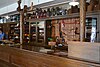 More images | |
| Alex Mclean House | 1328-1332 Hollis Street Halifax NS | 44°38′33″N 63°34′13″W / 44.6426°N 63.5704°W / 44.6426; -63.5704 (Alex Mclean House) | Halifax municipality (5324) |  | |
| National Film Board Building | 1572 Barrington Street Halifax NS | 44°38′43″N 63°34′26″W / 44.6453°N 63.5738°W / 44.6453; -63.5738 (National Film Board Building) | Halifax municipality (5553) |  | |
| Pacific Building | 1537 Barrington Street Halifax NS | 44°38′42″N 63°34′22″W / 44.6451°N 63.5727°W / 44.6451; -63.5727 (Pacific Building) | Halifax municipality (5640) |  | |
| Prince and Hollis Buildings | 5136-38 Prince Street; 5140 Prince Street; 5144 Prince Street; 1695 Hollis Street Halifax NS | 44°38′51″N 63°34′21″W / 44.6475°N 63.5724°W / 44.6475; -63.5724 (Prince and Hollis Buildings) | Nova Scotia (6642) | | |
| William DeBlois House | 1346 Hollis Street Halifax NS | 44°38′34″N 63°34′14″W / 44.6429°N 63.5706°W / 44.6429; -63.5706 (William DeBlois House) | Halifax municipality (6785) |  | |
| St. Mary's Basilica | 5221 Spring Garden Road Halifax NS | 44°38′40″N 63°34′24″W / 44.6444°N 63.5733°W / 44.6444; -63.5733 (St. Mary's Basilica) | Nova Scotia (7218) | More images | |
| Grafton Street Methodist Church | 1544 Grafton Street Halifax NS | 44°38′41″N 63°34′30″W / 44.6446°N 63.575°W / 44.6446; -63.575 (Grafton Street Methodist Church) | Nova Scotia (7332) |  | |
| Morse's Teas | 1877-79 Hollis Street Halifax NS | 44°39′00″N 63°34′26″W / 44.65°N 63.574°W / 44.65; -63.574 (Morse's Teas) | Halifax municipality (7955) |  | |
| Nova Scotia Furnishings | 1668 Barrington Street Halifax NS | 44°38′48″N 63°34′26″W / 44.6466°N 63.5739°W / 44.6466; -63.5739 (Nova Scotia Furnishings) | Halifax municipality (7957) |  | |
| G.M. Smith Building | 1715-19 Barrington Street Halifax NS | 44°38′51″N 63°34′27″W / 44.6475°N 63.5741°W / 44.6475; -63.5741 (G.M. Smith Building) | Halifax municipality (7993) |  | |
| St. Matthew's Manse | 1355 Barrington Street Halifax NS | 44°38′34″N 63°34′18″W / 44.6427°N 63.5718°W / 44.6427; -63.5718 (St. Matthew's Manse) | Halifax municipality (8015) |  | |
| W. M. Brown Building | 1549-51 Barrington Street Halifax NS | 44°38′43″N 63°34′23″W / 44.6452°N 63.573°W / 44.6452; -63.573 (W. M. Brown Building) | Halifax municipality (8069) |  | |
| 1724 Granville Street | 1724 Granville Street Halifax NS | 44°38′52″N 63°34′25″W / 44.6477°N 63.5736°W / 44.6477; -63.5736 (1724 Granville Street) | Halifax municipality (10536) | Upload Photo | |
| Black-Binney House National Historic Site of Canada | 1472 Hollis Street Halifax NS | 44°38′36″N 63°34′14″W / 44.6432°N 63.5706°W / 44.6432; -63.5706 (Black-Binney House National Historic Site of Canada) | Federal (10583), Halifax municipality (6850) |  | |
| Keith Hall and Brewery | 1475 Hollis Street; 1496 Lower Water Street Halifax NS | 44°38′41″N 63°34′17″W / 44.6446°N 63.5713°W / 44.6446; -63.5713 (Keith Hall and Brewery) | Halifax municipality (11003) |  | |
| Building 6 | Royal Artillery Park Halifax NS | 44°38′42″N 63°34′35″W / 44.6451°N 63.5765°W / 44.6451; -63.5765 (Building 6) | Federal (11269) | Upload Photo | |
| Halifax City Hall National Historic Site of Canada | 1841 Argyle Street Halifax NS | 44°38′56″N 63°34′30″W / 44.6488°N 63.575°W / 44.6488; -63.575 (Halifax City Hall National Historic Site of Canada) | Federal (12061), Halifax municipality (3277) |  More images | |
| Granville Block National Historic Site of Canada | Granville, Hollis and Duke Streets Halifax NS | 44°38′59″N 63°34′28″W / 44.6498°N 63.5744°W / 44.6498; -63.5744 (Granville Block National Historic Site of Canada) | Federal (12463) |  | |
| S.S. Acadia National Historic Site of Canada | 1675 Lower Water Street Halifax NS | 44°38′53″N 63°34′12″W / 44.648°N 63.5701°W / 44.648; -63.5701 (S.S. Acadia National Historic Site of Canada) | Federal (12741) |  | |
| HMCS Sackville National Historic Site of Canada | 1655 Lower Water Street Halifax NS | 44°38′51″N 63°34′12″W / 44.6474°N 63.57°W / 44.6474; -63.57 (HMCS Sackville National Historic Site of Canada) | Federal (14548) |  More images | |
| Jonathan McCully House National Historic Site of Canada | 2507 Brunswick Street Halifax NS | 44°39′27″N 63°35′17″W / 44.6574°N 63.5881°W / 44.6574; -63.5881 (Jonathan McCully House National Historic Site of Canada) | Federal (1144) |  | |
| Africville National Historic Site of Canada | Seaview Park Halifax NS | 44°40′28″N 63°37′10″W / 44.6744°N 63.6194°W / 44.6744; -63.6194 (Africville National Historic Site of Canada) | Federal (1153) |  More images | |
| Charles F. Dewolf House | 2125 Brunswick Street Halifax NS | 44°39′11″N 63°34′53″W / 44.6531°N 63.5813°W / 44.6531; -63.5813 (Charles F. Dewolf House) | Halifax municipality (1545) |  | |
| Ott-Beamish Cottage | 2229 Brunswick Street Halifax NS | 44°39′14″N 63°34′57″W / 44.6538°N 63.5825°W / 44.6538; -63.5825 (Ott-Beamish Cottage) | Halifax municipality (1966) |  | |
| David Starr House | 2415 Brunswick Street Halifax NS | 44°39′22″N 63°35′09″W / 44.6562°N 63.5859°W / 44.6562; -63.5859 (David Starr House) | Halifax municipality (2380) |  | |
| West-Hawkins House | 2421 Brunswick Street Halifax NS | 44°39′23″N 63°35′10″W / 44.6563°N 63.586°W / 44.6563; -63.586 (West-Hawkins House) | Halifax municipality (2456) |  | |
| James West House | 2461-2463 Brunswick Street Halifax NS | 44°39′24″N 63°35′13″W / 44.6568°N 63.5869°W / 44.6568; -63.5869 (James West House) | Halifax municipality (2457) |  | |
| Fraser House | 2223 Brunswick Street Halifax NS | 44°39′14″N 63°34′57″W / 44.6538°N 63.5824°W / 44.6538; -63.5824 (Fraser House) | Halifax municipality (2458) |  | |
| Halifax Forum | 2901 Windsor Street Halifax NS | 44°39′20″N 63°36′17″W / 44.6555°N 63.6046°W / 44.6555; -63.6046 (Halifax Forum) | Halifax municipality (3142) |  | |
| Smyth House | 2237 Brunswick Street Halifax NS | 44°39′14″N 63°34′58″W / 44.6539°N 63.5827°W / 44.6539; -63.5827 (Smyth House) | Halifax municipality (3247) |  | |
| Huestis House | 2275 Brunswick Street Halifax NS | 44°39′16″N 63°35′00″W / 44.6544°N 63.5834°W / 44.6544; -63.5834 (Huestis House) | Halifax municipality (3248) |  | |
| Hennessey Place Hydrostones | 5520-5532 Hennessey Place Halifax NS | 44°39′44″N 63°35′59″W / 44.6623°N 63.5997°W / 44.6623; -63.5997 (Hennessey Place Hydrostones) | Halifax municipality (3377) |  | |
| Fleming House | 2549-2553 Brunswick Street Halifax NS | 44°39′28″N 63°35′19″W / 44.6579°N 63.5885°W / 44.6579; -63.5885 (Fleming House) | Halifax municipality (3378) |  | |
| Halifax Relief Commission Building | 5555 Young Street Halifax NS | 44°39′42″N 63°35′59″W / 44.6618°N 63.5998°W / 44.6618; -63.5998 (Halifax Relief Commission Building) | Halifax municipality (3439) |  | |
| Hydrostone Market | 5515-5547 Young Street Halifax NS | 44°39′44″N 63°35′58″W / 44.6621°N 63.5994°W / 44.6621; -63.5994 (Hydrostone Market) | Halifax municipality (3565) |  More images | |
| West-Vaux House | 2427-2429 Brunswick Street Halifax NS | 44°39′23″N 63°35′10″W / 44.6563°N 63.5862°W / 44.6563; -63.5862 (West-Vaux House) | Halifax municipality (3585) |  | |
| West-Webster House | 2138 Brunswick Street Halifax NS | 44°39′10″N 63°34′55″W / 44.6528°N 63.5819°W / 44.6528; -63.5819 (West-Webster House) | Nova Scotia (3679) |  | |
| Walden Square | 5419 Portland Place Halifax NS | 44°39′08″N 63°34′52″W / 44.6521°N 63.5812°W / 44.6521; -63.5812 (Walden Square) | Halifax municipality (3731) |  | |
| St. Mark's Church | 5522 Russell Street Halifax NS | 44°39′40″N 63°35′51″W / 44.6611°N 63.5974°W / 44.6611; -63.5974 (St. Mark's Church) | Halifax municipality (3826) |  | |
| Avery House | 2370 Moran Street Halifax NS | 44°39′07″N 63°35′24″W / 44.652°N 63.59°W / 44.652; -63.59 (Avery House) | Halifax municipality (3849) |  | |
| Universalist Church | 2146 Brunswick Street Halifax NS | 44°39′11″N 63°34′55″W / 44.653°N 63.582°W / 44.653; -63.582 (Universalist Church) | Nova Scotia (3897) | Upload Photo | |
| West-Buley House | 2146 Brunswick Street Halifax NS | 44°39′11″N 63°34′55″W / 44.6531°N 63.582°W / 44.6531; -63.582 (West-Buley House) | Nova Scotia (7394) | Upload Photo | |
| Princess Place Victorian Townhouses | 2323-2337 Princess Place Halifax NS | 44°39′06″N 63°35′27″W / 44.6517°N 63.5908°W / 44.6517; -63.5908 (Princess Place Victorian Townhouses) | Halifax municipality (4010) |  | |
| Churchfield Barracks | 2046-2068 Brunswick Street Halifax NS | 44°39′06″N 63°34′49″W / 44.6517°N 63.5802°W / 44.6517; -63.5802 (Churchfield Barracks) | Halifax municipality (4122) |  | |
| Henry Busch House | 2575-2581 Creighton Street Halifax NS | 44°39′23″N 63°35′29″W / 44.6565°N 63.5913°W / 44.6565; -63.5913 (Henry Busch House) | Halifax municipality (4162) |  | |
| Stone House | 25049 Highway no. 7 Port Dufferin NS | 44°54′17″N 62°23′45″W / 44.9046°N 62.3957°W / 44.9046; -62.3957 (Stone House) | Port Dufferin municipality (7093) | Upload Photo | |
| St. George's Anglican / Round Church National Historic Site of Canada | 2222 Brunswick Street Halifax NS | 44°39′14″N 63°34′59″W / 44.6538°N 63.5831°W / 44.6538; -63.5831 (St. George's Anglican / Round Church National Historic Site of Canada) | Federal (4446), Nova Scotia (6566), Halifax municipality (3403) |  More images | |
| Little Dutch (Deutsch) Church National Historic Site of Canada | 2393 Brunswick Street Halifax NS | 44°39′21″N 63°35′08″W / 44.6558°N 63.5856°W / 44.6558; -63.5856 (Little Dutch Church National Historic Site of Canada) | Federal (12462), Nova Scotia (6482), Halifax municipality (3252) |  More images | |
| West-Osler House | 2140 Brunswick Street Halifax NS | 44°39′10″N 63°34′55″W / 44.6529°N 63.582°W / 44.6529; -63.582 (West-Osler House) | Nova Scotia (7395) |  | |
| Hydrostone District National Historic Site of Canada | Hydrostone neighbourhood Halifax NS | 44°39′47″N 63°36′09″W / 44.663°N 63.6025°W / 44.663; -63.6025 (Hydrostone District National Historic Site of Canada) | Federal (7625) | | |
| Church of Holy Redeemer | 2128 Brunswick Street Halifax NS | 44°39′10″N 63°34′54″W / 44.6529°N 63.5816°W / 44.6529; -63.5816 (Church of Holy Redeemer) | Halifax municipality (7956) |  | |
| 5522 North Street | 5522 North Street Halifax NS | 44°39′24″N 63°35′30″W / 44.6568°N 63.5917°W / 44.6568; -63.5917 (5522 North Street) | Halifax municipality (10382) |  | |
| 5516 North Street | 5516 North Street Halifax NS | 44°39′25″N 63°35′30″W / 44.6569°N 63.5917°W / 44.6569; -63.5917 (5516 North Street) | Halifax municipality (10387) |  | |
| 2548 Gottingen Street | 2548 Gottingen Street Halifax NS | 44°39′25″N 63°35′26″W / 44.657°N 63.5906°W / 44.657; -63.5906 (2548 Gottingen Street) | Halifax municipality (10574) |  | |
| 5355 Russell Street | 5355 Russell Street Halifax NS | 44°39′45″N 63°35′44″W / 44.6626°N 63.5956°W / 44.6626; -63.5956 (5355 Russell Street) | Halifax municipality (10701) |  | |
| Halifax Drill Hall National Historic Site of Canada | 2667 North Park Street Halifax NS | 44°39′06″N 63°35′13″W / 44.6518°N 63.5869°W / 44.6518; -63.5869 (Halifax Drill Hall National Historic Site of Canada) | Federal (13395, (3160) |  | |
| Akins House National Historic Site of Canada | 2151 Brunswick Street Halifax NS | 44°39′12″N 63°34′55″W / 44.6533°N 63.582°W / 44.6533; -63.582 (Akins House National Historic Site of Canada) | Federal (13963) |  | |
| Chebucto School | 6199 Chebucto Road Halifax NS | 44°39′01″N 63°35′52″W / 44.6502°N 63.5977°W / 44.6502; -63.5977 (Chebucto School) | Halifax municipality (3479) |  | |
| Pineo House (Caribou Lodge) | 6 Armada Drive Halifax NS | 44°40′26″N 63°38′50″W / 44.6738°N 63.6473°W / 44.6738; -63.6473 (Pineo House (Caribou Lodge)) | Halifax municipality (3376) |  | |
| D'Anville's Encampment National Historic Site of Canada | Centennial Park, Bedford Highway Halifax NS | 44°40′29″N 63°38′48″W / 44.6747°N 63.6466°W / 44.6747; -63.6466 (D'Anville's Encampment National Historic Site of Canada) | Federal (14826) |  | |
| Mont Blanc Anchor Site | 110 Spinnaker Drive Halifax NS | 44°38′16″N 63°36′58″W / 44.6377°N 63.6162°W / 44.6377; -63.6162 (Mont Blanc Anchor Site) | Halifax municipality (2582) |  More images | |
| 11 St. Margaret's Bay Road | 11 St. Margaret's Bay Road Halifax NS | 44°38′30″N 63°37′22″W / 44.6416°N 63.6229°W / 44.6416; -63.6229 (11 St. Margaret's Bay Road) | Halifax municipality (10926) |  More images | |
| St. Augustine's Chapel | 68 Parkhill Road Halifax NS | 44°37′43″N 63°35′50″W / 44.6287°N 63.5971°W / 44.6287; -63.5971 (St. Augustine's Chapel) | Halifax municipality (2383) | Upload Photo | |
| Building S-27 | CFB Halifax Halifax NS | 44°39′32″N 63°35′38″W / 44.659°N 63.594°W / 44.659; -63.594 (Building S-27) | Federal (2930) | Upload Photo | |
| Rose Bank Cottage | 268 Highway 357 Musquodoboit Harbour NS | 44°47′48″N 63°09′31″W / 44.7968°N 63.1585°W / 44.7968; -63.1585 (Rose Bank Cottage) | Nova Scotia (3408) | Upload Photo | |
| Musquodoboit Harbour Railway Museum | 7895 Highway 7 Musquodoboit Harbour NS | 44°54′14″N 62°24′01″W / 44.9039°N 62.4002°W / 44.9039; -62.4002 (Musquodoboit Harbour Railway Museum) | Musquodoboit Harbour municipality (5334) |  More images | |
| Lighttower | Sambro Island NS | 44°26′00″N 63°34′00″W / 44.4333°N 63.5667°W / 44.4333; -63.5667 (Lighttower (Sambro Island)) | Federal (3204) |  | |
| Mackey House | 1137 Ketch Harbour Road Ketch Harbour NS | 44°29′31″N 63°33′10″W / 44.4919°N 63.5528°W / 44.4919; -63.5528 (Mackey House) | Nova Scotia (15383) | Upload Photo | |
| Lock #5, Shubenacadie Canal | 53 Kings Road Wellington NS | 44°51′50″N 63°37′26″W / 44.8639°N 63.624°W / 44.8639; -63.624 (Lock #5, Shubenacadie Canal) | Nova Scotia (1788) | Upload Photo | |
| St. James United Church | 43 Old Taylor Head Road Spry Bay NS | 44°50′19″N 62°34′59″W / 44.8385°N 62.5831°W / 44.8385; -62.5831 (St. James United Church) | Spry Bay municipality (7249) | Upload Photo | |
| Memory Lane Heritage Village | 28 Clam Harbour Road Lake Charlotte NS | 44°45′50″N 62°56′46″W / 44.764°N 62.946°W / 44.764; -62.946 (Memory Lane Heritage Village) | Lake Charlotte municipality (8044) | Upload Photo | |
| 782 East Chezzetcook Road | 782 East Chezzetcook Road East Chezzetcook NS | 44°43′14″N 63°14′08″W / 44.7206°N 63.2355°W / 44.7206; -63.2355 (782 East Chezzetcook Road) | East Chezzetcook municipality (8046) | Upload Photo | |
| Dorey House | 15 Dorey Lane Queensland NS | 44°38′21″N 64°01′02″W / 44.6393°N 64.0171°W / 44.6393; -64.0171 (Dorey House) | Queensland municipality (7250) | Upload Photo | |
| MacPhee House | 22404 Highway 7 Sheet Harbour NS | 44°55′39″N 62°32′37″W / 44.9276°N 62.5435°W / 44.9276; -62.5435 (MacPhee House) | Sheet Harbour municipality (10927) | Upload Photo | |
| 1991 Prince Arthur Street | 1991 Prince Arthur Street Halifax NS | 44°38′28″N 63°36′32″W / 44.6411°N 63.6089°W / 44.6411; -63.6089 (1991 Prince Arthur Street) | Halifax municipality (10459) |  |
See also
Wikimedia Commons has media related to Cultural heritage monuments in Nova Scotia.
- History of Nova Scotia
- History of the Halifax Regional Municipality
- List of National Historic Sites of Canada in Nova Scotia
- List of oldest buildings and structures in Halifax, Nova Scotia
References
- v
- t
- e
- CRHP
- Annapolis County
- Antigonish County
- Cape Breton RM
- Colchester County
- Cumberland County
- Digby County
- Guysborough County
- Halifax RM
- Hants County
- Inverness County
- Kings County
- Lunenburg County
- Pictou County
- Region of Queens Municipality
- Richmond County
- Shelburne County
- Victoria County
- Yarmouth County
- Acacia Grove / Prescott House
- Admiralty House
- Africville
- Akins House
- Alexander Graham Bell
- Annapolis County Court House
- Annapolis Royal Historic District
- Antigonish County Court House
- Argyle Township Court House and Jail
- Beaubassin
- Bedford Petroglyphs
- Beinn Bhreagh Hall
- Black-Binney House
- Bloody Creek
- Canso Islands
- Cast Iron Façade / Coomb's Old English Shoe Store
- Chapel Island
- Chapman House
- Charles Fort
- Covenaters' Church
- D'Anville's Encampment
- Debert Palaeo-Indian Site
- Fernwood
- Fort Anne
- Fort Edward
- Fort Lawrence
- Fort McNab
- Fort St. Louis
- Fort Sainte Marie de Grace
- Fortress of Louisbourg
- Georges Island
- Government House
- Grand-Pré & Grand-Pré Rural Historic District
- Granville Block
- Grassy Island Fort
- Halifax Citadel
- Halifax City Hall
- Halifax Court House
- Halifax Armoury
- Halifax Dockyard
- Halifax Public Gardens
- Halifax Waterfront Buildings
- Halifax WWII Coastal Defences
- Henry House
- HMCS Sackville
- Hydrostone District
- Jonathan McCully House
- Kejimkujik
- King's College
- Knaut–Rhuland House
- Ladies' Seminary
- Little Dutch (Deutsch) Church
- Liverpool Town Hall
- Lunenburg Academy
- Marconi & Marconi Wireless Station
- Melanson Settlement
- Melville Island & Deadman's Island
- Nova Scotia Coal Fields
- Old Barrington Meeting House
- Old Burying Ground
- Old Town Lunenburg Historic District
- Pictou Academy
- Pictou Railway Station (Intercolonial)
- Pier 21
- Port-Royal
- Prince of Wales Tower
- Province House
- Royal Battery
- SS Acadia
- Sainte-Anne / Port Dauphin
- Sinclair Inn / Farmer's Hotel
- Sir Frederick Borden Residence
- Springhill Coal Mining
- St. George's Anglican Church / Round Church
- St. John's Anglican Church
- St. Mary's Basilica
- St. Paul's Anglican Church
- St. Peter's
- St. Peters Canal
- Sydney WWII Coastal Defences
- Thinkers' Lodge
- Trinity Anglican Church
- Truro Old Normal College
- Truro Post Office
- Wolfe's Landing
- York Redoubt
areas & others
 Category
 Commons
 Canada portal


