Maanselkä
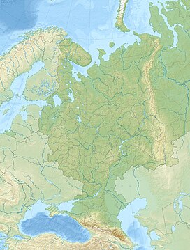

Location
Show map of European Russia
Maanselkä (Finland)
Show map of FinlandLapland, (Finland)
Republic of Karelia
Murmansk Oblast,
(Russia)
Maanselkä or Maanselka[3][4] (Finnish: Maanselkä; Russian: Манселькя) is a hilly region in Finland and Russia. It is located at the northern end of the East European Plain, around the Arctic Circle.
The Urho Kekkonen National Park, Oulanka National Park and Paanajärvi National Park are protected areas partly located in the Maanselkä hills. The main economic activities of the area are skiing, forestry, reindeer herding, hunting, as well as fishing in the lakes and rivers.[5]
Geography
Maanselkä is an extensive chain of smooth hills forming a watershed that separates the rivers flowing into the Baltic Sea from those flowing into the White Sea of the Arctic Ocean. It is located in northeastern Finland, in the eastern parts of North Ostrobothnia and Lapland, by the Russian border. In Russia the southern part of the range is in Karelia and the northern in Murmansk Oblast. To the northwest the drainage divide extends further into northern Norway.[2]
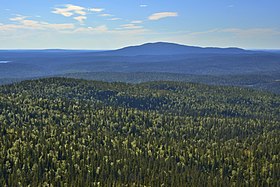
The hills are low and rounded. The highest point is Mt Sokusti, a 718 meters (2,356 ft) high summit in Saariselkä, on the Finnish side.[6] The highest point of Karelia, the 576 meters (1,890 ft) high Nuorunen, is located in the Russian side of the hill region.[7] There are many lakes in the intermontane basins, as well as rivers with poorly drained valleys and swampy forests. The highest elevations are treeless and barren, with some mountain tundra vegetation.[5]
Geologically Maanselkä is part of the central zone of the Baltic Shield. There are numerous traces of the erosional activity of ancient glaciers across the hills, such as lateral moraines and outwash plains.[5]
 |  |
See also
References
- ^ Painting by finnish painter Maija Kellokumpu (1892 - 1935)
- ^ a b Google Earth
- ^ A Gazetteer of the World, Volume 5, p. 12
- ^ James Bell, A System of Geography, Popular and Scientific, Volume 1, p. 41
- ^ a b c "Манселькя". Great Soviet Encyclopedia.
- ^ Full text of "Julkaisuja = Communicationes = Publications"
- ^ Gora Nuorunen - Peak Visor
External links
 Media related to Maanselkä at Wikimedia Commons
- Studies on the vegetational history of the Kuusamo district (North East Finland) during the Late-quaternary period.
- Vuokrataanko tunturi Neuvostoliitosta? Kylmän sodan Kuusamossa heräsi ennakkoluuloton hanke - Suomalaiset halusivat vuokrata tunturin ja tehdä alueelle viisumivapaan matkailukohteen.
- v
- t
- e
 | This Russian location article is a stub. You can help Wikipedia by expanding it. |
- v
- t
- e
 | This Republic of Karelia location article is a stub. You can help Wikipedia by expanding it. |
- v
- t
- e
 | This Murmansk Oblast location article is a stub. You can help Wikipedia by expanding it. |
- v
- t
- e


