Meredith, Colorado
Unincorporated community in Colorado, United States
39°21′44″N 106°43′50″W / 39.36222°N 106.73056°W / 39.36222; -106.73056 United States
 Colorado
81642
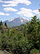
Meredith is an unincorporated community and a U.S. Post Office in Pitkin County, Colorado, United States. The Meredith Post Office has the ZIP Code 81642.[2]
Meredith was a limestone quarry town as well as a lumber camp in the 1890s. It is now mainly a "resort area". There are many original occupied buildings.
Geography
Meredith is located at 39°21′44″N 106°43′50″W / 39.36222°N 106.73056°W / 39.36222; -106.73056 (39.362174,-106.730633).
Climate
| Climate data for Meredith, Colorado, 1991–2020 normals: 7825ft (2385m) | |||||||||||||
|---|---|---|---|---|---|---|---|---|---|---|---|---|---|
| Month | Jan | Feb | Mar | Apr | May | Jun | Jul | Aug | Sep | Oct | Nov | Dec | Year |
| Record high °F (°C) | 58 (14) | 59 (15) | 65 (18) | 75 (24) | 89 (32) | 91 (33) | 98 (37) | 93 (34) | 90 (32) | 80 (27) | 68 (20) | 59 (15) | 98 (37) |
| Mean maximum °F (°C) | 48 (9) | 50 (10) | 56 (13) | 66 (19) | 76 (24) | 85 (29) | 89 (32) | 87 (31) | 83 (28) | 73 (23) | 60 (16) | 50 (10) | 92 (33) |
| Mean daily maximum °F (°C) | 34.1 (1.2) | 35.7 (2.1) | 42.9 (6.1) | 51.0 (10.6) | 62.9 (17.2) | 74.5 (23.6) | 81.1 (27.3) | 79.7 (26.5) | 71.2 (21.8) | 61.1 (16.2) | 44.6 (7.0) | 33.7 (0.9) | 56.0 (13.4) |
| Daily mean °F (°C) | 18.8 (−7.3) | 20.7 (−6.3) | 28.1 (−2.2) | 35.8 (2.1) | 45.6 (7.6) | 54.3 (12.4) | 60.4 (15.8) | 59.4 (15.2) | 51.6 (10.9) | 42.2 (5.7) | 28.9 (−1.7) | 19.2 (−7.1) | 38.7 (3.8) |
| Mean daily minimum °F (°C) | 3.5 (−15.8) | 5.7 (−14.6) | 13.2 (−10.4) | 20.6 (−6.3) | 28.4 (−2.0) | 34.1 (1.2) | 39.7 (4.3) | 39.1 (3.9) | 31.9 (−0.1) | 23.3 (−4.8) | 13.2 (−10.4) | 4.7 (−15.2) | 21.5 (−5.8) |
| Mean minimum °F (°C) | −17 (−27) | −16 (−27) | −7 (−22) | 7 (−14) | 17 (−8) | 25 (−4) | 31 (−1) | 31 (−1) | 21 (−6) | 11 (−12) | −7 (−22) | −15 (−26) | −22 (−30) |
| Record low °F (°C) | −29 (−34) | −38 (−39) | −30 (−34) | −7 (−22) | 6 (−14) | 17 (−8) | 23 (−5) | 23 (−5) | 12 (−11) | −5 (−21) | −21 (−29) | −35 (−37) | −38 (−39) |
| Average precipitation inches (mm) | 1.50 (38) | 1.57 (40) | 1.85 (47) | 2.15 (55) | 1.87 (47) | 1.05 (27) | 1.70 (43) | 1.65 (42) | 1.97 (50) | 1.71 (43) | 1.53 (39) | 1.15 (29) | 19.7 (500) |
| Average snowfall inches (cm) | 19.0 (48) | 14.6 (37) | 11.6 (29) | 7.7 (20) | 1.9 (4.8) | 0.0 (0.0) | 0.0 (0.0) | 0.0 (0.0) | 0.2 (0.51) | 3.4 (8.6) | 10.5 (27) | 19.1 (49) | 88 (223.91) |
| Source 1: NOAA[3] | |||||||||||||
| Source 2: XMACIS (records & monthly max/mins & Basalt precip/snowfall)[4] | |||||||||||||
See also
 Geography portal
 North America portal
 United States portal
 Colorado portal


- Colorado
References
- ^ a b "US Board on Geographic Names". United States Geological Survey. October 25, 2007. Retrieved January 31, 2008.
- ^ a b "ZIP Code Lookup". United States Postal Service. January 2, 2007. Archived from the original (JavaScript/HTML) on January 1, 2008. Retrieved January 2, 2007.
- ^ "Meredith, Colorado 1991-2020 Monthly Normals". Retrieved November 3, 2023.
- ^ "xmACIS". National Oceanic and Atmospheric Administration. Retrieved November 3, 2023.
External links
Meredith, Colorado at Wikipedia's sister projects
 Definitions from Wiktionary
 Media from Commons
 News from Wikinews
 Quotations from Wikiquote
 Texts from Wikisource
 Textbooks from Wikibooks
 Resources from Wikiversity
- v
- t
- e
- Aspen Mountain
- Aspen Highlands
- Buttermilk
- Snowmass
- Sunlight
- Crystal River
- Fryingpan River
- Roaring Fork River
- Ruedi Reservoir
Municipalities and communities of Pitkin County, Colorado, United States | ||
|---|---|---|
County seat: Aspen | ||
| City | 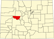 | |
| Towns | ||
| CDPs | ||
| Unincorporated communities |
| |
| Ghost towns | ||
| Footnotes | ‡This populated place also has portions in an adjacent county or counties | |
| ||
 | This Colorado-related article is a stub. You can help Wikipedia by expanding it. |
- v
- t
- e


