Mezőberény
You can help expand this article with text translated from the corresponding article in Hungarian. (February 2011) Click [show] for important translation instructions.
- View a machine-translated version of the Hungarian article.
- Machine translation, like DeepL or Google Translate, is a useful starting point for translations, but translators must revise errors as necessary and confirm that the translation is accurate, rather than simply copy-pasting machine-translated text into the English Wikipedia.
- Do not translate text that appears unreliable or low-quality. If possible, verify the text with references provided in the foreign-language article.
- You must provide copyright attribution in the edit summary accompanying your translation by providing an interlanguage link to the source of your translation. A model attribution edit summary is
Content in this edit is translated from the existing Hungarian Wikipedia article at [[:hu:Mezőberény]]; see its history for attribution. - You may also add the template
{{Translated|hu|Mezőberény}}to the talk page. - For more guidance, see Wikipedia:Translation.
Town in Békés, Hungary

Flag

Coat of arms
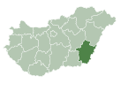
 Hungary
 (2009)
5650
46°49′N 21°1′E / 46.817°N 21.017°E / 46.817; 21.017
Mezőberény (Hungarian pronunciation: [ˈmɛzøːbɛreːɲ]; German: Maisbrünn; Slovak: Poľný Berinčok) is a town in Békés county, Hungary.
Location
Mezőberény is located in the Great Hungarian Plain, 200 km southeast from Budapest. Highway 46, 47 and Budapest-Szolnok-Békéscsaba-Lökösháza high speed (120–160 km/h (75–99 mph)) railway line also cross the town.[1]
History
The Medieval village of Berény was ruined due to the Ottoman wars, native Hungarian population fled from the area. It was rebuilt in the 18th century with German, Hungarian and Slovak settlers and was a multiethnic town until the late 19th century, when Germans and Slovaks adopted the Hungarian language.[2] In 1881, the town had a population of 11,368 people, of which 4,267 were Slovaks, 3,860 Hungarians, 2,614 Germans and 627 of other ethnicites.[3]
Notable people
See also: Category:People from Békés County
- Soma Orlai Petrich (1822–1880), painter
Twin towns – sister cities
Mezőberény is twinned with:[4]
 Čantavir (Subotica), Serbia
 Gronau, Germany
 Kolárovo, Slovakia
- Münsingen, Germany
 Sovata, Romania


References
- ^ Magyarország autóatlasz, Dimap-Szarvas, Budapest, 2004, ISBN 963-03-7576-1
- ^ Károly Kocsis (DSc, University of Miskolc) – Zsolt Bottlik (PhD, Budapest University) – Patrik Tátrai: Etnikai térfolyamatok a Kárpát-medence határon túli régióiban, Magyar Tudományos Akadémia (Hungarian Academy of Sciences) – Földrajtudományi Kutatóintézet (Academy of Geographical Studies); Budapest; 2006.; ISBN 963-9545-10-4, CD Atlas
- ^ "Hungarian 1881 census" (in Hungarian). Retrieved 8 December 2022.
- ^ "Testvérvárosaink". mezobereny.hu (in Hungarian). Mezőberény. Retrieved 2024-02-22.
External links
Wikimedia Commons has media related to Mezőberény.
- Official website (in Hungarian)
- Guide Mezőberény (in Hungarian)

| ||
|---|---|---|
| City with county rights |
|   |
| Towns | ||
| Large villages | ||
| Villages |
| |
| Other topics |
| |
Authority control databases | |
|---|---|
| International |
|
| National |
|
| Geographic |
|
| Other |
|
 | This Békés County location article is a stub. You can help Wikipedia by expanding it. |
- v
- t
- e
  | This Hungarian history article is a stub. You can help Wikipedia by expanding it. |
- v
- t
- e


