Mocho-Choshuenco National Reserve
The Mocho-Choshuenco National Reserve (Pronounced: /ˌmɒtʃoʊ tʃɒʃˈwɛnkoʊ/ MOTCH-oh chosh-WEN-koh) is a natural reserve around the Mocho-Choshuenco volcano, in Los Ríos Region, southern Chile. The reserve was created by decree in March 1994 and covers 7,537 ha (18,620 acres) distributed in Panguipulli, Los Lagos and Futrono municipality. The principal access goes from the Pan American Highway to Enco passing by Panguipulli and Choshuenco. From Enco a small way goes to the refuge area, during the summer months tracked vehicles can go there.
Mocho-Choshuenco National Reserve has no park guards or any public infrastructure. In the refuge sector there is a mountain hut leased to Los Lagos municipality, some old military buildings ruins, and the rests of a small ski centre.
Gallery
-
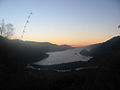 Sunset on Riñihue Lake, view from Mocho-Choshuenco
 -
 Río Blanco Valley. Río Blanco river drains the west side of Mocho-Choshuenco to the Enco River.


References
- ^ "Mocho-Choshuenco National Reserve". protectedplanet.net.
External links
- (in Spanish) A specialized blog about Mocho-Choshuenco National Reserve at mochochoshuenco.blogspot.com
- v
- t
- e

- Alto Bío Bío
- Alto Loa
- Altos de Lircay
- Altos de Pemehue
- Carlos Anwandter
- China Muerta
- Coyhaique
- El Yali
- Federico Albert
- Francisco Coloane
- Futaleufú
- Isla Mocha
- Katalalixar
- La Chimba
- Lago Carlota
- Lago Las Torres
- Lago Palena
- Lago Peñuelas
- Lago Rosselot
- Laguna Parrillar
- Laguna Torca
- Las Chinchillas
- Las Guaitecas
- Las Vicuñas
- Llanquihue
- Los Bellotos del Melado
- Los Flamencos
- Los Huemules de Niblinto
- Los Queules
- Los Ruiles
- Magallanes
- Malalcahuello
- Malleco
- Mocho-Choshuenco
- Nalcas
- Ñuble
- Pampa del Tamarugal
- Pingüino de Humboldt
- Radal Siete Tazas
- Ralco
- Río Blanco
- Río Clarillo
- Río Los Cipreses
- Río Simpson
- Roblería del Cobre de Loncha
- Trapananda
- Valdivian Coastal
- Villarrica
- Yerba Loca
 | This Los Ríos Region location article is a stub. You can help Wikipedia by expanding it. |
- v
- t
- e
 | This article related to a protected area in South America is a stub. You can help Wikipedia by expanding it. |
- v
- t
- e


