Mount Ashitaka
Eroded stratovolcano southeast of Mount Fuji


Ashitaka
Mount Ashitaka (Japan)
Mount Ashitaka (愛鷹山, Ashitakayama) is an eroded stratovolcano in the area south-east of Mount Fuji, Japan. Its highest peak, 1,504 metres (4,934 ft) high,[4] is Mount Echizen-dake, but the complex is named after its secondary peak, Ashitaka-yama, 1,188 m (3,898 ft) high.
Detailed map
Echizendake(1504)
Ashitaka(1188)
Ihaidake(1458)
Kurodake(1087)
Ōtake(1262)
Yobikodake(1310)
Maedake(1336)
class=notpageimage|
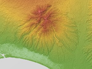
Topographic map of Ashitaka VolcanoGallery
-
 From the south.
 -
 From above
 -
 From Mount Fuji


See also
References
- ^ a b "Ashitaka". Global Volcanism Program. Smithsonian Institution. Retrieved 25 June 2021.
- ^ "Topographic map of Mount Ashitaka". opentopomap.org. Retrieved 15 June 2023.
- ^ "Ashitaka Yama". Geological Survey of Japan. Retrieved 15 June 2023.
- ^ Karátson, D (1999). "Erosion calderas: origins, processes, structural and climatic control". Bulletin of Volcanology. 61: 179. doi:10.1007/s004450050270.
The page incorporated material from Japanese Wikipedia page 愛鷹山, accessed 23 April 2019
External links
- Ashitaka Yama - Geological Survey of Japan
| Authority control databases |
|
|---|
- v
- t
- e


