Mount Tuzo
Mountain peak in Alberta/British Columbia, Canada


Mount Tuzo
Location in Alberta
Show map of Alberta
Mount Tuzo
Mount Tuzo (British Columbia)
Show map of British Columbia- Banff National Park
- Kootenay National Park
Canadian Rockies
Henrietta Tuzo, Christian Kaufmann
Mount Tuzo is a mountain located within the Valley of the Ten Peaks in the Canadian Rockies, along the Continental Divide, which forms the provincial boundary between British Columbia and Alberta in Western Canada.[1][3][5] It also lies on the boundary shared by Banff National Park and Kootenay National Park.
The mountain was named in 1907 after its first ascendant, Henrietta L. Tuzo. Tuzo was a charter member of the Alpine Club of Canada.[5][3] On his 1894 map, Samuel Allen had named the peak "Shagowa", which is the Nakoda word for seven as the mountain is seventh in order from south to north of the ten peaks.[3]
Geology
Like other mountains in Banff Park, Mount Tuzo is composed of sedimentary rock laid down from the Precambrian to Jurassic periods.[6] Formed in shallow seas, this sedimentary rock was pushed east and over the top of younger rock during the Laramide orogeny.[7]
Climate
Based on the Köppen climate classification, Mount Tuzo is located in a subarctic climate zone with cold, snowy winters, and mild summers.[8] Temperatures can drop below -20 °C with wind chill factors below -30 °C.
See also
- List of peaks on the Alberta–British Columbia border
- List of mountains in the Canadian Rockies
 Mountains portal

Gallery
-
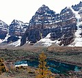
 Tuzo (right of center) from Moraine Lake
 -
 Northwest aspect from Eiffel Lake


References
- ^ a b "Mount Tuzo". cdnrockiesdatabases.ca. Retrieved 2019-09-13.
- ^ "Topographic map of Mount xyz". opentopomap.org. Retrieved 2023-09-14.
- ^ a b c d "Mount Tuzo". Bivouac.com. Retrieved 2019-09-13.
- ^ a b "Mount Tuzo (Alberta)". Geographical Names Data Base. Natural Resources Canada. Retrieved 2019-09-13.
- ^ a b "Mount Tuzo". BC Geographical Names. Retrieved 2023-09-14.
- ^ Belyea, Helen R. (1960). The Story of the Mountains in Banff National Park (PDF). parkscanadahistory.com (Report). Ottawa: Geological Survey of Canada. Archived (PDF) from the original on 2015-10-02. Retrieved 2019-09-13.
- ^ Gadd, Ben (2008). "Geology of the Rocky Mountains and Columbias" (PDF). Archived from the original (PDF) on 2012-04-02. Retrieved 2010-01-01.
- ^ Peel, M. C.; Finlayson, B. L.; McMahon, T. A. (2007). "Updated world map of the Köppen−Geiger climate classification". Hydrol. Earth Syst. Sci. 11: 1633–1644. ISSN 1027-5606.
- v
- t
- e
- Ball
- Bare
- Beaverfoot
- Blue
- Bow
- Crowsnest
- Elk
- Fairholme
- Fiddle
- Flathead
- Foothills
- High Rock
- Kananaskis
- Livingstone
- Lizard
- Maligne
- Massive
- Misty
- Morrissey
- Palliser
- President
- Queen Elizabeth
- Rainbow
- Ram
- Sawback
- Sentinel
- Slate
- South Jasper
- Sundance
- Terminal
- Tower of London
- Vermilion
- Victoria Cross
- Waputik
- Winston Churchill
- Continental Ranges
- Hart Ranges
- Muskwa Ranges
- Alberta
- Andromeda
- Assiniboine
- Athabasca
- Brazeau
- Bryce
- Cascade
- Castle
- Castleguard
- Clemenceau
- Columbia
- Cory
- Edith Cavell
- Forbes
- Hector
- Hosmer
- Hungabee
- Joffre
- Kitchener
- Lyell
- Heart
- Pilot
- Pyramid
- Resplendent
- Robson
- Rundle
- Sarbach
- Saskatchewan
- Smythe
- Snow Dome
- Stanley Peak
- Sulphur
- Temple
- Three Sisters
- Trinity
- Twin
- Ulysses
- Unnamed Alberta–BC mountain (formerly Mount Pétain)
- Whymper
see List of rivers of the Canadian Rockies and Category:Rivers of the Canadian Rockies
- Mountain Stoney
- Mountain Metis
| International | |
|---|---|
| National |
|
| Provincial (AB) |
|
| Provincial (BC) |
- See also
- Geography portal
- Canada portal


