Pianottoli-Caldarello
Commune in Corsica, France
You can help expand this article with text translated from the corresponding article in French. (January 2009) Click [show] for important translation instructions.
- View a machine-translated version of the French article.
- Machine translation, like DeepL or Google Translate, is a useful starting point for translations, but translators must revise errors as necessary and confirm that the translation is accurate, rather than simply copy-pasting machine-translated text into the English Wikipedia.
- Do not translate text that appears unreliable or low-quality. If possible, verify the text with references provided in the foreign-language article.
- You must provide copyright attribution in the edit summary accompanying your translation by providing an interlanguage link to the source of your translation. A model attribution edit summary is
Content in this edit is translated from the existing French Wikipedia article at [[:fr:Pianotolli-Caldarello]]; see its history for attribution. - You may also add the template
{{Translated|fr|Pianotolli-Caldarello}}to the talk page. - For more guidance, see Wikipedia:Translation.
Commune in Corsica, France
Pianottoli-Caldarello Pianottuli Caldareddu | ||
|---|---|---|
Commune | ||
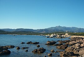 Anse de Chevanu | ||
Location of Pianottoli-Caldarello  | ||
(2020–2026) Charles Henri Bianconi[1] | | |
| Area 1 | 43 km2 (17 sq mi) | |
| Population (2021)[2] | 851 | |
| • Density | 20/km2 (51/sq mi) | |
| Time zone | UTC+01:00 (CET) | |
| • Summer (DST) | UTC+02:00 (CEST) | |
| INSEE/Postal code | 2A215 /20131 | |
| Elevation | 0–1,321 m (0–4,334 ft) (avg. 80 m or 260 ft) | |
| 1 French Land Register data, which excludes lakes, ponds, glaciers > 1 km2 (0.386 sq mi or 247 acres) and river estuaries. | ||
Pianottoli-Caldarello (Italian pronunciation: [pjaˈnɔttoli kaldaˈrɛllo]; French: [pjanɔtɔli kaldaʁɛlo]; Corsican: Pianottuli è Caldareddu) is a commune in the Corse-du-Sud department of France on the island of Corsica.[3]
It is part of the canton of Grand Sud.[3]
Geography
Pianottoli-Caldarello is 9 kilometres (6 mi) to the west of the commune of Figari on the road to Sartène. Originally named Caldarello, it was detached from Zérubia in 1864 then changed its name in 1921. The commune comprises predominantly shoreline with the Bay of Figari to the east, Point Capineru, the small islands of Bruzzi (a nature reserve) and two deep coves (Chevanu and Arbitru). A small port is developing near Caldarello to the east. The rocky hinterland extends in the direction of Mount Cagna to the north, going up to 1,340 metres (4,400 ft) on Ovace; for a long tome it served as pasturage for Zérubia, and is still used for that purpose.[4]
Population
| Year | Pop. | ±% p.a. |
|---|---|---|
| 1968 | 310 | — |
| 1975 | 794 | +14.38% |
| 1982 | 889 | +1.63% |
| 1990 | 653 | −3.78% |
| 1999 | 729 | +1.23% |
| 2009 | 864 | +1.71% |
| 2014 | 959 | +2.11% |
| 2020 | 901 | −1.03% |
| Source: INSEE[5] | ||
Sights
- Torra di Caldarellu
See also
References
- ^ "Répertoire national des élus: les maires". data.gouv.fr, Plateforme ouverte des données publiques françaises (in French). 2 December 2020.
- ^ "Populations légales 2021". The National Institute of Statistics and Economic Studies. 28 December 2023.
- ^ a b Commune de Pianottoli-Caldarello (2A215), INSEE
- ^ "France, le trésor des régions: Département: Corse-du-Sud" (in French). Retrieved 6 May 2008..
- ^ Population en historique depuis 1968, INSEE
Wikimedia Commons has media related to Pianottoli-Caldarello.
- v
- t
- e
 Communes of the Corse-du-Sud department
- Afa
- Ajacciopref
- Alata
- Albitreccia
- Altagène
- Ambiegna
- Appietto
- Arbellara
- Arbori
- Argiusta-Moriccio
- Arro
- Aullène
- Azilone-Ampaza
- Azzana
- Balogna
- Bastelica
- Bastelicaccia
- Belvédère-Campomoro
- Bilia
- Bocognano
- Bonifacio
- Calcatoggio
- Campo
- Cannelle
- Carbini
- Carbuccia
- Cardo-Torgia
- Cargèse
- Cargiaca
- Casaglione
- Casalabriva
- Cauro
- Ciamannacce
- Coggia
- Cognocoli-Monticchi
- Conca
- Corrano
- Coti-Chiavari
- Cozzano
- Cristinacce
- Cuttoli-Corticchiato
- Eccica-Suarella
- Évisa
- Figari
- Foce
- Forciolo
- Fozzano
- Frasseto
- Giuncheto
- Granace
- Grossa
- Grosseto-Prugna
- Guagno
- Guargualé
- Guitera-les-Bains
- Lecci
- Letia
- Levie
- Lopigna
- Loreto-di-Tallano
- Marignana
- Mela
- Moca-Croce
- Monacia-d'Aullène
- Murzo
- Ocana
- Olivese
- Olmeto
- Olmiccia
- Orto
- Osani
- Ota
- Palneca
- Partinello
- Pastricciola
- Peri
- Petreto-Bicchisano
- Piana
- Pianottoli-Caldarello
- Pietrosella
- Pila-Canale
- Poggiolo
- Porto-Vecchio
- Propriano
- Quasquara
- Quenza
- Renno
- Rezza
- Rosazia
- Sainte-Lucie-de-Tallano
- Salice
- Sampolo
- San-Gavino-di-Carbini
- Santa-Maria-Figaniella
- Santa-Maria-Siché
- Sant'Andréa-d'Orcino
- Sari-d'Orcino
- Sari-Solenzara
- Sarrola-Carcopino
- Sartènesubpr
- Serra-di-Ferro
- Serra-di-Scopamène
- Serriera
- Soccia
- Sollacaro
- Sorbollano
- Sotta
- Tasso
- Tavaco
- Tavera
- Tolla
- Ucciani
- Urbalacone
- Valle-di-Mezzana
- Vero
- Vico
- Viggianello
- Villanova
- Zérubia
- Zévaco
- Zicavo
- Zigliara
- Zonza
- Zoza
- pref: prefecture
- subpr: subprefecture
Authority control databases | |
|---|---|
| International |
|
| National |
|
 | This Corse-du-Sud geographical article is a stub. You can help Wikipedia by expanding it. |
- v
- t
- e


