Plouagat
Part of Châtelaudren-Plouagat in Brittany, France
Plouagat Plagad | |
|---|---|
Part of Châtelaudren-Plouagat | |
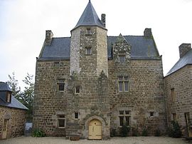 Manor house of Fournebello | |
 Coat of arms | |
Location of Plouagat  | |
48°32′15″N 2°59′51″W / 48.5375°N 2.9975°W / 48.5375; -2.9975 | |
| Country | France |
| Region | Brittany |
| Department | Côtes-d'Armor |
| Arrondissement | Guingamp |
| Canton | Plélo |
| Commune | Châtelaudren-Plouagat |
| Area 1 | 31.98 km2 (12.35 sq mi) |
| Population (2019)[1] | 2,906 |
| • Density | 91/km2 (240/sq mi) |
| Time zone | UTC+01:00 (CET) |
| • Summer (DST) | UTC+02:00 (CEST) |
| Postal code | 22170 |
| Elevation | 68–262 m (223–860 ft) |
| 1 French Land Register data, which excludes lakes, ponds, glaciers > 1 km2 (0.386 sq mi or 247 acres) and river estuaries. | |
Plouagat (French pronunciation: [pluaɡat]; Breton: Plagad; Gallo: Plagat) is a former commune in the Côtes-d'Armor department of Brittany in northwestern France. On 1 January 2019, it was merged into the new commune Châtelaudren-Plouagat.[2]
Population
| Year | Pop. | ±% |
|---|---|---|
| 1962 | 1,522 | — |
| 1968 | 1,472 | −3.3% |
| 1975 | 1,727 | +17.3% |
| 1982 | 1,978 | +14.5% |
| 1990 | 2,154 | +8.9% |
| 1999 | 2,218 | +3.0% |
| 2008 | 2,436 | +9.8% |
Inhabitants of Plouagat are called plouagatins in French.
See also
References
External links
Wikimedia Commons has media related to Plouagat.
- Base Mérimée: Search for heritage in the commune, Ministère français de la Culture. (in French)
| Authority control databases: National |
|
|---|
- v
- t
- e


