Racine Harbor Lighthouse and Life Saving Station
United States historic place
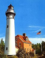
Racine Harbor Lighthouse and Life Saving Station | |
 Racine Harbor Lighthouse and Life Saving Station | |
| Location | Racine, Wisconsin |
|---|---|
| Coordinates | 42°44′03″N 87°46′43″W / 42.73405°N 87.7787°W / 42.73405; -87.7787 |
| NRHP reference No. | 75000077 |
| Added to NRHP | September 9, 1975 |
The Racine Harbor Lighthouse and Life Saving Station is a complex of navigation aids begun by the U.S. government in the 1860s near the harbor of Racine, Wisconsin. It was added to the National Register of Historic Places in 1975.[1][2]
To guide ships into Racine's harbor, the federal government in 1837 built the first lighthouse at the mouth of the Root River, with a light on a 34 feet (10 m) tower and a lightkeeper's house. Those structures no longer exist.[3]
In the early 1860s the pier was extended, and a new lighthouse and keeper's quarters were begun on a rock-filled crib 200 feet (61 m) offshore. They were completed in 1866 and served for 40 years. In 1903 the light was moved from the old lighthouse to a free-standing 120-foot steel tower, and the tower of the old lighthouse was capped with a hip roof.[4][2]
The life-saving station was added in 1903, a 2-story building with a 3-story square, pyramidal-roofed lookout tower. Part of the station was a frame boathouse. A team from the Life-Saving Service lived in this station, and conducted search and rescue operations along the Milwaukee-Kenosha coast and 40 miles (64 km) out into Lake Michigan.[2]
See also
- Racine Reef Light
- Wind Point Light
- Racine North Breakwater Light
References
- ^ "Racine Harbor Light". National Park Service. Retrieved 2013-05-30.
- ^ a b c Allan Heninger (1975-05-02). "NRHP Inventory/Nomination: Racine Harbor Lighthouse and Life Saving Station". National Park Service. Retrieved 2018-07-24. With one photo.
- ^ Pepper, Terry. "Root River Lights". Seeing the Light. Terry Pepper. Retrieved 2018-07-27.
- ^ "Racine Harbor Lighthouse and Life Saving Station". Wisconsin Historical Society. January 2012. Retrieved 2018-07-24.
- v
- t
- e
Lighthouses of Wisconsin
- Ashland Harbor Breakwater
- Chequamegon Point
- Devils Island
- Gull Island
- La Pointe
- Michigan Island
- Outer Island
- Raspberry Island
- Sand Island
- Wisconsin Point
- Algoma
- Baileys Harbor
- Baileys Harbor Range
- Cana Island
- Chambers Island
- Dunlap Reef Range
- Eagle Bluff
- Grassy Island Range
- Green Bay Harbor Entrance
- Green island
- Kenosha
- Kenosha North Pier
- Kevich
- Kewaunee Pierhead
- Long Tail
- Manitowoc Breakwater
- Milwaukee Breakwater
- Milwaukee Pierhead
- North Point
- Peshtigo Reef
- Pilot Island
- Plum Island Range
- Port Washington
- Port Washington Breakwater
- Pottawatomie
- Racine Harbor
- Racine North Breakwater
- Racine Reef
- Rawley Point
- Sheboygan
- Sherwood Point
- Sturgeon Bay Canal
- Sturgeon Bay Canal North Pierhead
- Two Rivers
- Wind Point
- Dunlap Reef Range Front
- Manitowoc Main
- Manitowoc North Pierhead
- Plum Island Range Front
- Racine North Pierhead


