Saint-Bonnet-de-Rochefort
You can help expand this article with text translated from the corresponding article in French. (December 2008) Click [show] for important translation instructions.
- View a machine-translated version of the French article.
- Machine translation, like DeepL or Google Translate, is a useful starting point for translations, but translators must revise errors as necessary and confirm that the translation is accurate, rather than simply copy-pasting machine-translated text into the English Wikipedia.
- Do not translate text that appears unreliable or low-quality. If possible, verify the text with references provided in the foreign-language article.
- You must provide copyright attribution in the edit summary accompanying your translation by providing an interlanguage link to the source of your translation. A model attribution edit summary is
Content in this edit is translated from the existing French Wikipedia article at [[:fr:Saint-Bonnet-de-Rochefort]]; see its history for attribution. - You may also add the template
{{Translated|fr|Saint-Bonnet-de-Rochefort}}to the talk page. - For more guidance, see Wikipedia:Translation.
Commune in Auvergne-Rhône-Alpes, France

Coat of arms
Location of Saint-Bonnet-de-Rochefort

(2020–2026) Henri Giraud[1]
1
(2021)[2]
03220 /03800
(avg. 334 m or 1,096 ft)
Saint-Bonnet-de-Rochefort (French pronunciation: [sɛ̃ bɔnɛ də ʁɔʃfɔʁ]; Auvergnat: Sant Bonet de Ròchafòrt) is a commune in the Allier department in Auvergne-Rhône-Alpes in central France.
Geography
Saint-Bonnet-de-Rochefort is located in the south of the Allier department, 9 kilometres (5.6 mi) of Gannat, 3 kilometres (1.9 mi) of Vicq by departmental road 37; 5 kilometres (3.1 mi) of Ébreuil and Charroux by D35.
-
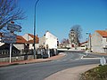 Departmental road 35 passing town centre.

Population
| Year | Pop. | ±% p.a. |
|---|---|---|
| 1968 | 701 | — |
| 1975 | 669 | −0.67% |
| 1982 | 715 | +0.95% |
| 1990 | 712 | −0.05% |
| 1999 | 656 | −0.91% |
| 2009 | 643 | −0.20% |
| 2014 | 674 | +0.95% |
| 2020 | 717 | +1.04% |
| Source: INSEE[3] | ||
See also
References
- ^ "Répertoire national des élus: les maires" (in French). data.gouv.fr, Plateforme ouverte des données publiques françaises. 13 September 2022.
- ^ "Populations légales 2021" (in French). The National Institute of Statistics and Economic Studies. 28 December 2023.
- ^ Population en historique depuis 1968, INSEE
Wikimedia Commons has media related to Saint-Bonnet-de-Rochefort.
- v
- t
- e
Communes of the Allier department 

- Abrest
- Agonges
- Ainay-le-Château
- Andelaroche
- Archignat
- Arfeuilles
- Arpheuilles-Saint-Priest
- Arronnes
- Aubigny
- Audes
- Aurouër
- Autry-Issards
- Avermes
- Avrilly
- Bagneux
- Barberier
- Barrais-Bussolles
- Bayet
- Beaulon
- Beaune-d'Allier
- Bègues
- Bellenaves
- Bellerive-sur-Allier
- Bert
- Bessay-sur-Allier
- Besson
- Bézenet
- Billezois
- Billy
- Biozat
- Bizeneuille
- Blomard
- Bost
- Boucé
- Le Bouchaud
- Bourbon-l'Archambault
- Braize
- Bransat
- Bresnay
- Bressolles
- Le Brethon
- Le Breuil
- Broût-Vernet
- Brugheas
- Busset
- Buxières-les-Mines
- La Celle
- Cérilly
- Cesset
- La Chabanne
- Chambérat
- Chamblet
- Chantelle
- Chapeau
- La Chapelaude
- La Chapelle
- La Chapelle-aux-Chasses
- Chappes
- Chareil-Cintrat
- Charmeil
- Charmes
- Charroux
- Chassenard
- Château-sur-Allier
- Châtel-de-Neuvre
- Châtel-Montagne
- Châtelperron
- Châtelus
- Châtillon
- Chavenon
- Chavroches
- Chazemais
- Chemilly
- Chevagnes
- Chezelle
- Chézy
- Chirat-l'Église
- Chouvigny
- Cindré
- Cognat-Lyonne
- Colombier
- Commentry
- Contigny
- Cosne-d'Allier
- Coulandon
- Coulanges
- Couleuvre
- Courçais
- Coutansouze
- Couzon
- Créchy
- Cressanges
- Creuzier-le-Neuf
- Creuzier-le-Vieux
- Cusset
- Deneuille-lès-Chantelle
- Deneuille-les-Mines
- Désertines
- Deux-Chaises
- Diou
- Domérat
- Dompierre-sur-Besbre
- Le Donjon
- Doyet
- Droiturier
- Durdat-Larequille
- Ébreuil
- Échassières
- Escurolles
- Espinasse-Vozelle
- Estivareilles
- Étroussat
- Ferrières-sur-Sichon
- La Ferté-Hauterive
- Fleuriel
- Fourilles
- Franchesse
- Gannat
- Gannay-sur-Loire
- Garnat-sur-Engièvre
- Gennetines
- Gipcy
- Gouise
- La Guillermie
- Haut-Bocage
- Hauterive
- Hérisson
- Huriel
- Hyds
- Isle-et-Bardais
- Isserpent
- Jaligny-sur-Besbre
- Jenzat
- Laféline
- Lalizolle
- Lamaids
- Langy
- Lapalisse
- Laprugne
- Lavault-Sainte-Anne
- Lavoine
- Lenax
- Lételon
- Liernolles
- Lignerolles
- Limoise
- Loddes
- Loriges
- Louchy-Montfand
- Louroux-Bourbonnais
- Louroux-de-Beaune
- Louroux-de-Bouble
- Luneau
- Lurcy-Lévis
- Lusigny
- Magnet
- Malicorne
- Marcenat
- Marcillat-en-Combraille
- Marigny
- Mariol
- Le Mayet-d'École
- Le Mayet-de-Montagne
- Mazerier
- Mazirat
- Meaulne-Vitray
- Meillard
- Meillers
- Mercy
- Mesples
- Molinet
- Molles
- Monestier
- Monétay-sur-Allier
- Monétay-sur-Loire
- Montaiguët-en-Forez
- Montaigu-le-Blin
- Montbeugny
- Montcombroux-les-Mines
- Monteignet-sur-l'Andelot
- Le Montet
- Montilly
- Montluçonsubpr
- Montmarault
- Montoldre
- Montord
- Montvicq
- Moulinspref
- Murat
- Nades
- Nassigny
- Naves
- Néris-les-Bains
- Neuilly-en-Donjon
- Neuilly-le-Réal
- Neure
- Neuvy
- Nizerolles
- Noyant-d'Allier
- Paray-le-Frésil
- Paray-sous-Briailles
- Périgny
- La Petite-Marche
- Pierrefitte-sur-Loire
- Le Pin
- Poëzat
- Pouzy-Mésangy
- Prémilhat
- Quinssaines
- Reugny
- Rocles
- Rongères
- Ronnet
- Saint-Angel
- Saint-Aubin-le-Monial
- Saint-Bonnet-de-Four
- Saint-Bonnet-de-Rochefort
- Saint-Bonnet-Tronçais
- Saint-Caprais
- Saint-Christophe-en-Bourbonnais
- Saint-Clément
- Saint-Désiré
- Saint-Didier-en-Donjon
- Saint-Didier-la-Forêt
- Saint-Éloy-d'Allier
- Saint-Ennemond
- Sainte-Thérence
- Saint-Étienne-de-Vicq
- Saint-Fargeol
- Saint-Félix
- Saint-Genest
- Saint-Gérand-de-Vaux
- Saint-Gérand-le-Puy
- Saint-Germain-de-Salles
- Saint-Germain-des-Fossés
- Saint-Hilaire
- Saint-Léger-sur-Vouzance
- Saint-Léon
- Saint-Léopardin-d'Augy
- Saint-Loup
- Saint-Marcel-en-Marcillat
- Saint-Marcel-en-Murat
- Saint-Martin-des-Lais
- Saint-Martinien
- Saint-Menoux
- Saint-Nicolas-des-Biefs
- Saint-Palais
- Saint-Pierre-Laval
- Saint-Plaisir
- Saint-Pont
- Saint-Pourçain-sur-Besbre
- Saint-Pourçain-sur-Sioule
- Saint-Priest-d'Andelot
- Saint-Priest-en-Murat
- Saint-Prix
- Saint-Rémy-en-Rollat
- Saint-Sauvier
- Saint-Sornin
- Saint-Victor
- Saint-Voir
- Saint-Yorre
- Saligny-sur-Roudon
- Sanssat
- Saulcet
- Saulzet
- Sauvagny
- Sazeret
- Serbannes
- Servilly
- Seuillet
- Sorbier
- Souvigny
- Sussat
- Target
- Taxat-Senat
- Teillet-Argenty
- Terjat
- Le Theil
- Theneuille
- Thiel-sur-Acolin
- Thionne
- Tortezais
- Toulon-sur-Allier
- Treban
- Treignat
- Treteau
- Trévol
- Trézelles
- Tronget
- Urçay
- Ussel-d'Allier
- Valignat
- Valigny
- Vallon-en-Sully
- Varennes-sur-Allier
- Varennes-sur-Tèche
- Vaumas
- Vaux
- Veauce
- Venas
- Vendat
- Verneix
- Le Vernet
- Verneuil-en-Bourbonnais
- Vernusse
- Le Veurdre
- Vichysubpr
- Vicq
- Vieure
- Le Vilhain
- Villebret
- Villefranche-d'Allier
- Villeneuve-sur-Allier
- Viplaix
- Voussac
- Ygrande
- Yzeure
- pref: prefecture
- subpr: subprefecture
 | This Allier geographical article is a stub. You can help Wikipedia by expanding it. |
- v
- t
- e


