Shabestar County
County in East Azerbaijan province, Iran
County in East Azerbaijan, Iran
Shabestar County Persian: شهرستان شبستر | |
|---|---|
County | |
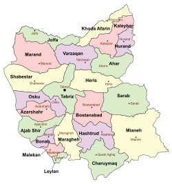 Location of Shabestar County in East Azerbaijan province (center left, yellow) | |
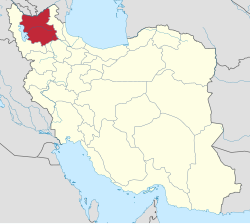 Location of East Azerbaijan province in Iran | |
| Coordinates: 38°14′N 45°43′E / 38.233°N 45.717°E / 38.233; 45.717[1] | |
| Country |  Iran Iran |
| Province | East Azerbaijan |
| Capital | Shabestar |
| Districts | Central, Sufian, Tasuj |
| Population (2016) | |
| • Total | 135,421 |
| Time zone | UTC+3:30 (IRST) |
| Shabestar County can be found at GEOnet Names Server, at this link, by opening the Advanced Search box, entering "9205857" in the "Unique Feature Id" form, and clicking on "Search Database". | |
Shabestar County (Persian: شهرستان شبستر) is in East Azerbaijan province, Iran. Its capital is the city of Shabestar.[2]
Demographics
Population
At the time of the 2006 National Census, the county's population was 121,787 in 33,255 households.[3] The following census in 2011 counted 124,499 people in 37,358 households.[4] The 2016 census measured the population of the county as 135,421 in 43,982 households.[5]
Administrative divisions
Shabestar County's population history and administrative structure over three consecutive censuses are shown in the following table.
| Administrative Divisions | 2006[3] | 2011[4] | 2016[5] |
|---|---|---|---|
| Central District | 64,312 | 70,218 | 78,933 |
| Guney-ye Markazi RD | 7,189 | 9,065 | 10,136 |
| Guney-ye Sharqi RD | 5,276 | 6,357 | 5,579 |
| Sis RD | 9,829 | 10,899 | 9,734 |
| Khamaneh (city) | 2,750 | 2,541 | 3,056 |
| Kuzeh Kanan (city) | 3,524 | 3,274 | 4,730 |
| Shabestar (city) | 13,857 | 15,663 | 22,181 |
| Sharafkhaneh (city) | 3,872 | 3,585 | 4,244 |
| Shendabad (city) | 8,797 | 9,034 | 8,489 |
| Sis (city) | 5,127 | 5,502 | 6,106 |
| Vayqan (city) | 4,091 | 4,298 | 4,678 |
| Sufian District | 38,767 | 36,235 | 37,646 |
| Chelleh Khaneh RD | 7,921 | 7,630 | 7,877 |
| Mishu-e Jonubi RD | 10,276 | 8,563 | 8,648 |
| Rudqat RD | 11,837 | 10,916 | 11,158 |
| Sufian (city) | 8,733 | 9,126 | 9,963 |
| Tasuj District | 18,708 | 18,046 | 18,842 |
| Chehregan RD | 3,509 | 3,171 | 2,981 |
| Guney-ye Gharbi RD | 7,867 | 7,505 | 8,339 |
| Tasuj (city) | 7,332 | 7,370 | 7,522 |
| Total | 121,787 | 124,499 | 135,421 |
| RD = Rural District | |||
Publications
International Journal of Forest, Soil and Erosion has been published as a peer-reviewed journal in Shabestar city since November 2011.
See also
![]() Media related to Shabestar County at Wikimedia Commons
Media related to Shabestar County at Wikimedia Commons
 Iran portal
References
- ^ OpenStreetMap contributors (4 April 2023). "Shabestar County" (Map). OpenStreetMap (in Persian). Retrieved 4 April 2023.
- ^ Habibi, Hassan (7 July 1369). "Approval of the organization and chain of citizenship of the elements and units of the country divisions of East Azerbaijan province centered on the city of Tabriz". Islamic Parliament Research Center (in Persian). Ministry of Interior, Defense Political Commission of the Government Board. Archived from the original on 4 August 2013. Retrieved 4 December 2023.
- ^ a b "Census of the Islamic Republic of Iran, 1385 (2006)". AMAR (in Persian). The Statistical Center of Iran. p. 03. Archived from the original (Excel) on 20 September 2011. Retrieved 25 September 2022.
- ^ a b "Census of the Islamic Republic of Iran, 1390 (2011)". Syracuse University (in Persian). The Statistical Center of Iran. p. 03. Archived from the original (Excel) on 16 January 2023. Retrieved 19 December 2022.
- ^ a b "Census of the Islamic Republic of Iran, 1395 (2016)". AMAR (in Persian). The Statistical Center of Iran. p. 03. Archived from the original (Excel) on 13 November 2020. Retrieved 19 December 2022.
- v
- t
- e

and
Sights
- Amir Nezam House
- Arasbaran
- Arg of Tabriz
- Azerbaijan Museum
- Babak Fort
- Bazaar of Tabriz
- Blue Mosque, Tabriz
- Eynali
- Quri-gol
- Haidar Zadeh house
- House of constitution
- Iron Age museum
- Jamee mosque of Tabriz
- Kandovan
- Khodaafarin Bridges
- Maqbaratoshoara
- Maragheh observatory
- Museum of Ostad Bohtouni
- Saint Stepanos Monastery
- Gonbad-e Sorkh
- El-Gölü
- Tabriz Municipality
- Zahhak Castle
- Kiz bridge
Shabestar County | |||||||||||||||||||||||||||||||||||
|---|---|---|---|---|---|---|---|---|---|---|---|---|---|---|---|---|---|---|---|---|---|---|---|---|---|---|---|---|---|---|---|---|---|---|---|
| Capital | |||||||||||||||||||||||||||||||||||
| Districts |
| ||||||||||||||||||||||||||||||||||


