Spéracèdes
Commune in Provence-Alpes-Côte d'Azur, France
You can help expand this article with text translated from the corresponding article in French. (December 2008) Click [show] for important translation instructions.
- View a machine-translated version of the French article.
- Machine translation, like DeepL or Google Translate, is a useful starting point for translations, but translators must revise errors as necessary and confirm that the translation is accurate, rather than simply copy-pasting machine-translated text into the English Wikipedia.
- Do not translate text that appears unreliable or low-quality. If possible, verify the text with references provided in the foreign-language article.
- You must provide copyright attribution in the edit summary accompanying your translation by providing an interlanguage link to the source of your translation. A model attribution edit summary is
Content in this edit is translated from the existing French Wikipedia article at [[:fr:Spéracèdes]]; see its history for attribution. - You may also add the template
{{Translated|fr|Spéracèdes}}to the talk page. - For more guidance, see Wikipedia:Translation.
Commune in Provence-Alpes-Côte d'Azur, France
Spéracèdes Las Perascedas (Occitan) | ||
|---|---|---|
Commune | ||
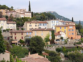 View of the village towards Cabris | ||
 Coat of arms | ||
Location of Spéracèdes  | ||
(2020–2026) Jean-Marc Macario[1] | | |
| Area 1 | 3.46 km2 (1.34 sq mi) | |
| Population (2021)[2] | 1,176 | |
| • Density | 340/km2 (880/sq mi) | |
| Time zone | UTC+01:00 (CET) | |
| • Summer (DST) | UTC+02:00 (CEST) | |
| INSEE/Postal code | 06137 /06530 | |
| Elevation | 204–790 m (669–2,592 ft) (avg. 390 m or 1,280 ft) | |
| 1 French Land Register data, which excludes lakes, ponds, glaciers > 1 km2 (0.386 sq mi or 247 acres) and river estuaries. | ||
Spéracèdes (French pronunciation: [speʁasɛd]; Occitan: Las Perascedas; Italian, formerly: Speiraceta) is a commune in the Alpes-Maritimes department in the Provence-Alpes-Côte d'Azur region in Southeastern France.
Part of Préalpes d'Azur Regional Natural Park,[3] Spéracèdes is located 7 km (4.3 mi) east of Grasse and 25 km (15.5 mi) northeast of Cannes on the Mediterranean coast. Its inhabitants are called Spéracèdois (masculine) and Spéracèdoises (feminine) in French.
Demographics
| Year | Pop. | ±% p.a. |
|---|---|---|
| 1968 | 531 | — |
| 1975 | 674 | +3.47% |
| 1982 | 764 | +1.81% |
| 1990 | 1,029 | +3.79% |
| 1999 | 1,095 | +0.69% |
| 2009 | 1,257 | +1.39% |
| 2014 | 1,293 | +0.57% |
| 2020 | 1,171 | −1.64% |
| Source: INSEE[4] | ||
See also
References
- ^ "Répertoire national des élus: les maires". data.gouv.fr, Plateforme ouverte des données publiques françaises (in French). 2 December 2020.
- ^ "Populations légales 2021". The National Institute of Statistics and Economic Studies. 28 December 2023.
- ^ (in French) Les communes du Parc, www.parc-prealpesdazur.fr.
- ^ Population en historique depuis 1968, INSEE
External links
- Commune's official website
- Commune's events, life, and news: "Spéracèdes Demain" association's website
Wikimedia Commons has media related to Spéracèdes.
- v
- t
- e

- Aiglun
- Amirat
- Andon
- Antibes
- Ascros
- Aspremont
- Auribeau-sur-Siagne
- Auvare
- Bairols
- Le Bar-sur-Loup
- Beaulieu-sur-Mer
- Beausoleil
- Belvédère
- Bendejun
- Berre-les-Alpes
- Beuil
- Bézaudun-les-Alpes
- Biot
- Blausasc
- La Bollène-Vésubie
- Bonson
- Bouyon
- Breil-sur-Roya
- Briançonnet
- La Brigue
- Le Broc
- Cabris
- Cagnes-sur-Mer
- Caille
- Cannes
- Le Cannet
- Cantaron
- Cap-d'Ail
- Carros
- Castagniers
- Castellar
- Castillon
- Caussols
- Châteauneuf-d'Entraunes
- Châteauneuf-Grasse
- Châteauneuf-Villevieille
- Cipières
- Clans
- Coaraze
- La Colle-sur-Loup
- Collongues
- Colomars
- Conségudes
- Contes
- Courmes
- Coursegoules
- La Croix-sur-Roudoule
- Cuébris
- Daluis
- Drap
- Duranus
- Entraunes
- L'Escarène
- Escragnolles
- Èze
- Falicon
- Les Ferres
- Fontan
- Gars
- Gattières
- La Gaude
- Gilette
- Gorbio
- Gourdon
- Grassesubpr
- Gréolières
- Guillaumes
- Ilonse
- Isola
- Lantosque
- Levens
- Lieuche
- Lucéram
- Malaussène
- Mandelieu-la-Napoule
- Marie
- Le Mas
- Massoins
- Menton
- Mouans-Sartoux
- Mougins
- Moulinet
- Les Mujouls
- Nicepref
- Opio
- Pégomas
- Peille
- Peillon
- La Penne
- Péone
- Peymeinade
- Pierlas
- Pierrefeu
- Puget-Rostang
- Puget-Théniers
- Revest-les-Roches
- Rigaud
- Rimplas
- Roquebillière
- Roquebrune-Cap-Martin
- La Roque-en-Provence
- Roquefort-les-Pins
- Roquestéron
- La Roquette-sur-Siagne
- La Roquette-sur-Var
- Roubion
- Roure
- Le Rouret
- Saint-André-de-la-Roche
- Saint-Antonin
- Saint-Auban
- Saint-Blaise
- Saint-Cézaire-sur-Siagne
- Saint-Dalmas-le-Selvage
- Sainte-Agnès
- Saint-Étienne-de-Tinée
- Saint-Jean-Cap-Ferrat
- Saint-Jeannet
- Saint-Laurent-du-Var
- Saint-Léger
- Saint-Martin-d'Entraunes
- Saint-Martin-du-Var
- Saint-Martin-Vésubie
- Saint-Paul-de-Vence
- Saint-Sauveur-sur-Tinée
- Saint-Vallier-de-Thiey
- Sallagriffon
- Saorge
- Sauze
- Séranon
- Sigale
- Sospel
- Spéracèdes
- Tende
- Théoule-sur-Mer
- Thiéry
- Le Tignet
- Toudon
- Touët-de-l'Escarène
- Touët-sur-Var
- La Tour
- Tourette-du-Château
- Tournefort
- Tourrette-Levens
- Tourrettes-sur-Loup
- La Trinité
- La Turbie
- Utelle
- Valbonne
- Valdeblore
- Valderoure
- Vallauris
- Venanson
- Vence
- Villars-sur-Var
- Villefranche-sur-Mer
- Villeneuve-d'Entraunes
- Villeneuve-Loubet
- pref: prefecture
- subpr: subprefecture


