Tourlaville
Part of Cherbourg-en-Cotentin in Normandy, France
Location of Tourlaville

49°38′30″N 1°34′39″W / 49.6417°N 1.5775°W / 49.6417; -1.5775
1
(2019)[1]
50110
(avg. 127 m or 417 ft)
Tourlaville (French pronunciation: [tuʁlavil]) is a former commune in the Manche department in Normandy in north-western France. On 1 January 2016, it was merged into the new commune of Cherbourg-en-Cotentin.[2]
Heraldry
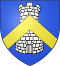 | The arms of Tourlaville are blazoned : Azure, a tower argent, overall a chevron or.
|
See also
References
Wikimedia Commons has media related to Tourlaville.
Authority control databases | |
|---|---|
| International |
|
| National |
|
- v
- t
- e


