Voivodeship road 430
You can help expand this article with text translated from the corresponding article in Polish. (June 2023) Click [show] for important translation instructions.
- Machine translation, like DeepL or Google Translate, is a useful starting point for translations, but translators must revise errors as necessary and confirm that the translation is accurate, rather than simply copy-pasting machine-translated text into the English Wikipedia.
- Do not translate text that appears unreliable or low-quality. If possible, verify the text with references provided in the foreign-language article.
- You must provide copyright attribution in the edit summary accompanying your translation by providing an interlanguage link to the source of your translation. A model attribution edit summary is
Content in this edit is translated from the existing Polish Wikipedia article at [[:pl:Droga wojewódzka nr 430]]; see its history for attribution. - You may also add the template
{{Translated|pl|Droga wojewódzka nr 430}}to the talk page. - For more guidance, see Wikipedia:Translation.
 | ||||
|---|---|---|---|---|
| Droga wojewódzka nr 430 | ||||
 | ||||
| Route information | ||||
| Maintained by Wielkopolski Zarząd Dróg Wojewódzkich, Zarząd Dróg Miejskich w Poznaniu | ||||
| Length | 25 km (16 mi) | |||
| Major junctions | ||||
| From | Poznań | |||
| To | Mosina | |||
| Location | ||||
| Country | Poland | |||
| Regions | Greater Poland Voivodeship | |||
| Major cities | Poznań | |||
| Highway system | ||||
| ||||
| ||||


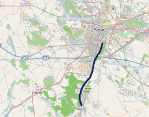
Voivodeship road 430 (Polish: Droga wojewódzka nr 430, abbreviated DW 430) is a route in the Polish voivodeship roads network. It runs through the Greater Poland Voivodeship (Poznań County), leading from Poznań, through Luboń and Puszczykowo to Mosina where it meets Voivodeship road 431.
Major cities and towns along the route
- Poznań (motorway A2, national road 5, national road 11, voivodeship road 196, Voivodeship road 433)
- Luboń
- Puszczykowo
- Mosina (Voivodeship road 431)
Route plan
| km | Icon | Name | Crossed roads |
|---|---|---|---|
| x | Mosina | Mocka Street  | |
| x | Puszczykowo | Dworcowa Street | |
| x | Puszczykowo | Poznańska Street | |
| x | Łęczyca | Local road | |
| x | Luboń | Kręta Street | |
| x | Level crossing in Luboń, railway No. 271 Poznań — Wrocław | — | |
| x | Luboń | Powstańców Wielkopolskich Street | |
| x | Luboń | Dębiecka Street | |
| x |  | Poznań – Luboń interchange (formerly "Dębina") |       |
| x | Poznań | 28 czerwca 1956 Street | |
| x |  | Poznań – Filling station (Shell) | — |
| x | Poznań | Czechosłowacka Street | |
| x |  | Short dual carriageway road stretch under railway bridge | — |
| x | Poznań | Piastowska Street | |
| x | Poznań | Wspólna Street | |
| x | | Poznań – Dolna Wilda interchange |   |
| x |  |  | |
| x |  | | |
| x | |  | |
| x | | |

52°15′13″N 16°51′01″E / 52.253743°N 16.850272°E / 52.253743; 16.850272
- v
- t
- e


