Zegveld
Town in Utrecht, Netherlands
Flag

Coat of arms
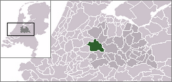

The village (dark green) and statistical district (light green) of Zegveld in the municipality of Woerden.
(1 January 2010)
Zegveld is a village in the Dutch province of Utrecht. It is a part of the municipality of Woerden and lies about 5 km northwest of Woerden.
In 2001 the town of Zegveld had 1,576 inhabitants. The built-up area of the town was 0.21 km2, and contained 563 residences.[1] The statistical district "Zegveld" has a population of around 2360.[2] This covers the entire former municipality, including the hamlets of Lagebroek and Stichtse Meije.
White storks
The village has a center for white storks to nest, a unique place in the area.
History
The village used to be a separate municipality. In 1989, it merged with Woerden. Unlike Woerden, Zegveld was always a part of the province of Utrecht.
References
- ^ Statistics Netherlands (CBS), Bevolkingskernen in Nederland 2001 "CBS - Bevolkingskernen in Nederland 2001". Archived from the original on March 19, 2006. Retrieved January 24, 2007.. Statistics are for the continuous built-up area.
- ^ Statistics Netherlands (CBS), Statline: Kerncijfers wijken en buurten 2003–2005 "Archived copy". Archived from the original on April 27, 1999. Retrieved July 24, 2006.
{{cite web}}: CS1 maint: archived copy as title (link). As of January 1, 2005.
- v
- t
- e
Populated places in the municipality of Woerden
- Woerden
- Harmelen
- Kamerik
- Kanis
- Zegveld
- Barwoutswaarder
- Breeveld
- Breudijk
- Geestdorp
- Gerverscop
- Harmelerwaard
- Houtdijken
- Kamerik-Mijzijde
- Meije (in part)
- Oud-Kamerik
- Reijerscop
- Rietveld
- Teckop
 | This Utrecht location article is a stub. You can help Wikipedia by expanding it. |
- v
- t
- e


