Reichenschwand
| Reichenschwand comune | |
|---|---|
 | |
 | |
| Localizzazione | |
| Stato |  Germania Germania |
| Land |  Baviera Baviera |
| Distretto |  Media Franconia Media Franconia |
| Circondario | Nürnberger Land |
| Territorio | |
| Coordinate | 49°30′54″N 11°22′19″E49°30′54″N, 11°22′19″E (Reichenschwand) |
| Altitudine | 345 m s.l.m. |
| Superficie | 6,84 km² |
| Abitanti | 2 262[1] (2006-12-31) |
| Densità | 330,7 ab./km² |
| Altre informazioni | |
| Cod. postale | 91244 |
| Prefisso | 09151 |
| Fuso orario | UTC+1 |
| Codice Destatis | 09 5 74 150 |
| Targa | LAU |
| Cartografia | |
  Reichenschwand | |
| Sito istituzionale | |
| Modifica dati su Wikidata · Manuale | |
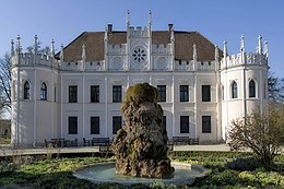
Reichenschwand è un comune tedesco di 2.262 abitanti, situato nel land della Baviera.
Altri progetti
Altri progetti
- Wikimedia Commons
 Wikimedia Commons contiene immagini o altri file su Reichenschwand
Collegamenti esterni
- Sito ufficiale, su reichenschwand.de.


V · D · M Suddivisioni del circondario del Nürnberger Land  | |
|---|---|
| Città | Altdorf bei Nürnberg · Hersbruck · Lauf an der Pegnitz · Röthenbach an der Pegnitz · Velden |
| Comuni mercato | Feucht · Neuhaus an der Pegnitz · Schnaittach |
| Comuni | Alfeld · Burgthann · Engelthal · Happurg · Hartenstein · Henfenfeld · Kirchensittenbach · Leinburg · Neunkirchen am Sand · Offenhausen · Ottensoos · Pommelsbrunn · Reichenschwand · Rückersdorf · Schwaig bei Nürnberg · Schwarzenbruck · Simmelsdorf · Vorra · Winkelhaid |
| Territori extracomunali | Behringersdorfer Forst · Brunn · Engelthaler Forst · Feuchter Forst · Fischbach · Forsthof · Günthersbühler Forst · Haimendorfer Forst · Laufamholzer Forst · Leinburg · Rückersdorfer Forst · Schönberg · Winkelhaid · Zerzabelshofer Forst |
| Controllo di autorità | VIAF (EN) 154849761 · LCCN (EN) n85813487 · GND (DE) 4116947-5 · J9U (EN, HE) 987007567262205171 |
|---|
 Portale Germania: accedi alle voci di Wikipedia che parlano della Germania
- ^ Ente statistico della Baviera - Dati sulla popolazione


