South Harrow
 South Harrow | |
|---|---|
 | |
| Stazione della | metropolitana di Londra |
| Gestore | Transport for London |
| Inaugurazione | 1903 |
| Stato | in uso |
| Linea | linea Piccadilly |
| Localizzazione | South Harrow, Harrow |
| Zona tariffaria | Zona 5 |
| Tipologia | stazione di superficie |
| Interscambio | linee di superficie |
| Flusso passeggeri | 2010 2011 2012 2013 2014 |
  South Harrow | |
| Metropolitane del mondo | |
| Modifica dati su Wikidata · Manuale | |
 | Cockfosters | ||||||
| | Oakwood | ||||||
| | Southgate | ||||||
| | Arnos Grove | ||||||
| | Bounds Green | ||||||
| | Wood Green | ||||||
| | Turnpike Lane | ||||||
| | Manor House | ||||||
 | | Finsbury Park | |||||
| | Arsenal | ||||||
| | Holloway Road | ||||||
| | Caledonian Road | ||||||
    | | King's Cross St. Pancras | |||||
| | Russell Square | ||||||
 | | Holborn | |||||
| | Covent Garden | ||||||
| | | Leicester Square | |||||
 | | Piccadilly Circus | |||||
 | | Green Park | |||||
| | Hyde Park Corner | ||||||
| | Knightsbridge | ||||||
 | | South Kensington | |||||
| | | Gloucester Road | |||||
| | | Earl's Court | |||||
| | | Barons Court | |||||
| | | Hammersmith | |||||
| | | Turnham Green | |||||
| | | Acton Town | |||||
| Ealing Common | | | South Ealing | ||||
| North Ealing | | | Northfields | ||||
| Park Royal | | | Boston Manor | ||||
| Alperton | | | Osterley | ||||
| Sudbury Town | | | Hounslow East | ||||
| Sudbury Hill | | | Hounslow Central | ||||
| South Harrow | | | Hounslow West | ||||
| Rayners Lane | | | Hatton Cross | ||||
| Eastcote | | | Heathrow T2 & 3   | ||||
| Ruislip Manor | | Heathrow T4 | | ||||
| Ruislip | | | Heathrow T5 | ||||
| Ickenham | | | |||||
| Hillingdon | | | |||||
| Uxbridge | | | |||||
La stazione di South Harrow è una stazione della linea Piccadilly della metropolitana di Londra.
Storia
La stazione della DR
La stazione di South Harrow è stata aperta nel 1903 dalla District Railway (DR, oggi la District line) come capolinea della nuova diramazione da Park Royal & Twyford Abbey[2]. A marzo del 1910 la DR è stata estesa verso nord per collegarsi alla Metropolitan Railway (MR, oggi la linea Metropolitan) nella stazione di Rayners Lane[2].
La stazione della linea Piccadilly
A luglio 1932 la linea Piccadilly è stata estesa da Hammersmith verso ovest, sostituendo i treni della linea District nel 1933[2]. Nel 1935 è stata costruita una nuova stazione, di fianco a quella originale che, ancora esistente, viene ancora utilizzata come spazio per uffici[2]. Il progetto del nuovo edificio è di Charles Holden e include una biglietteria a forma di cubo in mattoni e vetro, con una lastra di cemento armato per tetto. Nel 1954 ha chiuso lo scalo merci[3].
Interscambi
Nelle vicinanze della stazione effettuano fermata alcune linee urbane automobilistiche, gestite da London Buses[4].
 Fermata autobus

Galleria d'immagini
-
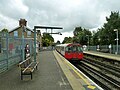
 I binari della stazione
 -
 La vecchia stazione
 -
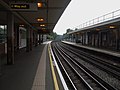 Il binario est
 -
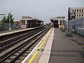 Il binario ovest


Note
- ^ a b c d e (EN) Multi-year station entry-and-exit figures (XLS), in London Underground station passenger usage data, Transport for London, 2017. URL consultato il 18 dicembre 2018.
- ^ a b c d DR.
- ^ Brian Hardy, How it used to be – freight on The Underground 50 years ago, in Underground News, n. 591, London Underground Railway Society, marzo 2011, pp. 175–183.
- ^ (EN) Buses nearby South Harrow Underground Station, su tfl.gov.uk. URL consultato il 18 dicembre 2018.
Bibliografia
- (EN) Douglas Rose, The London Underground, A Diagrammatic History, 7ª ed., Douglas Rose/Capital Transport, 1999 [1980], ISBN 1-85414-219-4.
- (EN) J.E. Connor, London's Disused Underground Stations, 2ª ed., Capital Transport, 2006 [1999], ISBN 1-85414-250-X.
- (EN) John R. Day, John Reed, The Story of London's Underground, 11ª ed., Capital Transport, 2010 [1963], ISBN 978-1-85414-341-9.
- (EN) Tony Beard, By Tube Beyond Edgware, Capital Transport, 2002, ISBN 978-1-85414-246-7.
- (EN) R.V.J. Butt, The Directory of Railway Stations, Patrick Stephens Ltd, 1995, ISBN 1-85260-508-1.
- (EN) Christian Wolmar, The Subterranean Railway: How the London Underground Was Built and How It Changed the City Forever, Atlantic Books, 2005 [2004], ISBN 978-1-84354-023-6.
- (EN) Joe Brown, London Railway Atlas, 3ª ed., Ian Allan Publishing, 2013, ISBN 978-0-7110-3728-1.
- Anthony Sutcliffe, London: An Architectural History, Yale University Press, 2006, ISBN 978-0-300-11006-7. URL consultato il 17 novembre 2018.
- Cyril M. Harris, What's in a name?, 4a, Capital Transport, 2001 [1977], ISBN 978-1-85414-241-2.
- Antony Badsey-Ellis, Underground Heritage, Capital Transport, 2012, ISBN 978-1-85414-360-0.
- David Bownes, Oliver Green e Sam Mullins, Underground: How the Tube Shaped London, Allen Lane, 2012, ISBN 978-1-84614-462-2.
- Mike Horne, The Northern Line: An Illustrated History, 3a, Capital Transport, 2009 [1990], ISBN 978-1-85414-326-6.
Altri progetti
Altri progetti
- Wikimedia Commons
 Wikimedia Commons contiene immagini o altri file su stazione di South Harrow
Collegamenti esterni
- South Harrow nell'archivio fotografico del London Transport Museum, su ltmuseum.co.uk.
| Capolinea | Fermata precedente |  | Fermata successiva | Capolinea | ||||
|---|---|---|---|---|---|---|---|---|
| Uxbridge |  | Rayners Lane | South Harrow | Sudbury Hill |  | Cockfosters |
 Portale Londra


