アダマ
 | この項目では、エチオピアの都市について説明しています。イスラエルの化学メーカーについては「マクテシム・アガン」をご覧ください。 |
アダマ | |
|---|---|
 | |
  アダマ アダマの位置 | |
| 北緯08度32分29秒 東経39度16分08秒 / 北緯8.54139度 東経39.26889度 / 8.54139; 39.26889座標: 北緯08度32分29秒 東経39度16分08秒 / 北緯8.54139度 東経39.26889度 / 8.54139; 39.26889 | |
| 国 | エチオピア |
| 州 | オロミア州 |
| 面積 | |
| • 合計 | 29.86 km2 |
| 標高 | 1,712 m |
| 人口 (2015年) | |
| • 合計 | 342,000人 |
| 等時帯 | UTC+3 (東アフリカ時間) |
| ケッペンの気候区分 | サバナ気候(Aw) |
アダマ (オロモ語:Adaamaa)(アムハラ語:አዳማ)はエチオピアのオロミア州の州都。[1][2] 東シェワ県(英語版)に囲まれる。 首都アディスアベバの南東99kmに位置する。 西には絶壁がそそり立ち、東には大地溝帯が南北に伸びる。
経済
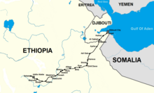
アダマは、アディスアベバとディレ・ダワを結ぶ交通の要所である。 ジブチ港との間を多くのトラックが行き交う。 かつてはアッサブ港とも結ばれていたが、エチオピア・エリトリア国境紛争(1998年~2000年)の後は使われなくなった。 アディスアベバ・ジブチ鉄道もアダマを通る。[2][3][4][5]
教育
- アダマ大学(英語版)
スポーツ
- アダマ市F.C.(英語版):エチオピアサッカー協会(英語版)に所属する。本拠地はアダマ競技場(英語版)。
歴史
第二次世界大戦後、ハイレ・セラシエ1世はイスラエルのナザレに因み、アダマからナザレに改称した。[4]
2000年、市は正式に名称をオロモ語のアダマに戻した。[4][6][7] また、オロミア州の州都をアディスアベバからアダマに変更した。[4] この変更について、反対派は「エチオピア政府はオロミア州の中でアディスアベバの地位を低下させたいのだ」と主張した。[8][9] 一方で賛成派は、「アディスアベバはオロモ人の言語や文化、歴史を発展させる中心として相応しくなくなったからだ」と主張した。[7]
2005年6月10日、与党エチオピア人民革命民主戦線(EPRDF)と連立を組むオロモ人民民主機構(OPDO)が、州都をフィンフィンネ(オロモ語でアディスアベバ)に戻す事を公式に宣言した。[10]
人口
民族
第一言語
宗教
姉妹都市


気候
サバナ気候(Aw)
| アダマの気候 | |||||||||||||
|---|---|---|---|---|---|---|---|---|---|---|---|---|---|
| 月 | 1月 | 2月 | 3月 | 4月 | 5月 | 6月 | 7月 | 8月 | 9月 | 10月 | 11月 | 12月 | 年 |
| 平均最高気温 °C (°F) | 27 (81) | 28.1 (82.6) | 29.6 (85.3) | 30.1 (86.2) | 30.5 (86.9) | 29.6 (85.3) | 24.4 (75.9) | 26.1 (79) | 27.5 (81.5) | 27.9 (82.2) | 26.7 (80.1) | 25.7 (78.3) | 27.77 (82.03) |
| 日平均気温 °C (°F) | 19.2 (66.6) | 20.4 (68.7) | 21.9 (71.4) | 22.6 (72.7) | 22.5 (72.5) | 22.4 (72.3) | 18.4 (65.1) | 20.6 (69.1) | 21.1 (70) | 20.1 (68.2) | 18.7 (65.7) | 18.1 (64.6) | 20.5 (68.91) |
| 平均最低気温 °C (°F) | 11.4 (52.5) | 12.8 (55) | 14.3 (57.7) | 15.2 (59.4) | 14.6 (58.3) | 15.3 (59.5) | 12.5 (54.5) | 15.1 (59.2) | 14.7 (58.5) | 12.3 (54.1) | 10.8 (51.4) | 10.6 (51.1) | 13.3 (55.93) |
| 降水量 mm (inch) | 11 (0.43) | 22 (0.87) | 45 (1.77) | 58 (2.28) | 43 (1.69) | 74 (2.91) | 201 (7.91) | 210 (8.27) | 101 (3.98) | 24 (0.94) | 13 (0.51) | 7 (0.28) | 809 (31.84) |
| 平均降雨日数 (≥1 mm) | 0 | 0 | 2 | 2 | 4 | 7 | 15 | 14 | 10 | 3 | 1 | 0 | 58 |
| 出典1:Climate-Data.org, altitude: 1618m[14] | |||||||||||||
| 出典2:Storm247 for rainy days[15] | |||||||||||||
脚注
- ^ 2009 CIA map marks Nazrēt (Adama) as an administrative (regional) capital..
- ^ a b Eritrea and Ethiopia (Map). 1:5,000,000. Central Intelligence Agency. 2009. Map #803395。
- ^ bing Maps (Map). Microsoft. 2011. 2011年5月5日閲覧。
- ^ a b c d Lindahl, Bernhard (2005年). “Naader - Neguz” (PDF). Nordic Africa Institute. pp. 8–13. 2011年9月20日閲覧。 “The name was changed from Adama (Hadama) to Nazret (Nazareth) a little before 1948. This belonged to a general pattern of introducing Christian names instead of traditional Oromo names.”
- ^ Lindahl, Bernhard (2005年). “Dil Amba - Djibiet” (pdf). Local History in Ethiopia. The Nordic Africa Institute. 2011年9月20日閲覧。 “The Franco-Ethiopian railway company in 1960-1963 carried out surveys for extending the railway with a 310 km line from Nazret to Dilla.”
- ^ “Aadu - Alyume” (PDF). Local History in Ethiopia. Nordic Africa Institute. p. 28 (2008年). 2010年11月11日閲覧。
- ^ a b “Nazareth Selected as Oromiya's Capital”. Walta Information Center (2000年7月13日). 2006年3月3日時点のオリジナルよりアーカイブ。2006年2月25日閲覧。
- ^ Hameso, Seyoum and Tilahun Ayanou Nebo (2000年). “Ethiopia: A New Start?”. The Sidama Concern. 2006年2月23日時点のオリジナルよりアーカイブ。2006年2月25日閲覧。
- ^ Mosisa, Abraham T. (2004年1月13日). “Letter to U.N. Secretary-General”. Oromo Studies Association. 2006年2月22日時点のオリジナルよりアーカイブ。2006年2月25日閲覧。
- ^ “Chief Administrator of Oromia says decision to move capital city based on study”. Walta Information Center (2005年6月11日). 2005年6月13日時点のオリジナルよりアーカイブ。2006年2月25日閲覧。
- ^ 2007 Population and Housing Census of Ethiopia: Results for Oromia Region, Vol. 1, Tables 2.1, 2.5, 3.4 (accessed 13 January 2012)
- ^ Uzaklar Yakinlaşti - Sivas Twin Towns(トルコ語)
- ^ “Aurora enters into first new sister city agreement: Adama, Ethiopia”. 2014年7月15日閲覧。
- ^ “Climate: Adama - Climate graph, Temperature graph, Climate table”. Climate-Data.org. 2013年10月23日閲覧。
- ^ “Weather for Adama, Ethiopia - Climate”. Storm247. 2013年10月23日閲覧。
参考文献
- Briggs, Philip. Guide to Ethiopia. Old Saybrook, Connecticut: Globe Pequot Press, 1995. ISBN 1-56440-814-0
外部リンク
- Adama Chamber of Commerce
- MSN Map - elevation = 2485
 ウィキメディア・コモンズには、アダマに関するカテゴリがあります。
 ウィキボヤージュには、アダマに関する旅行情報があります。
典拠管理データベース | |
|---|---|
| 全般 |
|
| 国立図書館 |
|


