Cersay
Plaats in Frankrijk  | |||
|---|---|---|---|
 | |||
  | |||
| Situering | |||
| Regio | Nouvelle-Aquitaine | ||
| Departement | Deux-Sèvres (79) | ||
| Arrondissement | Bressuire | ||
| Kanton | Le Val de Thouet | ||
| Gemeente | Val en Vignes | ||
| Coördinaten | 47° 3′ NB, 0° 21′ WL | ||
| Algemeen | |||
| Oppervlakte | 37,1 km² | ||
| Inwoners (2004) | 974 (26,3 inw./km²) | ||
| Hoogte | 59 - 112 m | ||
| Overig | |||
| Postcode(s) | 79290 | ||
| INSEE-code | 79063 | ||
| |||

Cersay is een plaats en voormalige gemeente in het Franse departement Deux-Sèvres in de regio Nouvelle-Aquitaine. De plaats maakt deel uit van het arrondissement Bressuire. Cersay fuseerde op 1 januari 2017 met de buurgemeenten Bouillé-Saint-Paul en Massais tot de commune nouvelle Val en Vignes.
Geografie
De oppervlakte van Cersay bedraagt 37,1 km², de bevolkingsdichtheid is 26,3 inwoners per km².
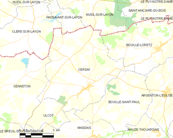
De onderstaande kaart toont de ligging van Cersay met de belangrijkste infrastructuur en aangrenzende gemeenten.
 |
Demografie
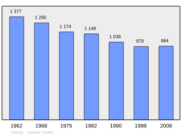
Onderstaande figuur toont het verloop van het inwonertal (bron: INSEE-tellingen).
Externe links
- (fr) Statistische informatie op de website van INSEE
Mediabestanden
Zie de categorie Cersay van Wikimedia Commons voor mediabestanden over dit onderwerp.


