Chamaret
Gemeente in Frankrijk  | |||
|---|---|---|---|
  | |||
| Situering | |||
| Regio | Auvergne-Rhône-Alpes | ||
| Departement | Drôme (26) | ||
| Arrondissement | Nyons | ||
| Kanton | Grignan | ||
| Coördinaten | 44° 24′ NB, 4° 54′ OL | ||
| Algemeen | |||
| Oppervlakte | 7,79 km² | ||
| Inwoners (1 januari 2021) | 512[1] (66 inw./km²) | ||
| Hoogte | 135 - 264 m | ||
| Overig | |||
| Postcode | 26230 | ||
| INSEE-code | 26070 | ||
| Website | Officiële website | ||
| Foto's | |||
 | |||
| Gezicht op Chamaret | |||
 | |||
| Gemeentehuis | |||
 | |||
| Landschap bij Chamaret | |||
| |||

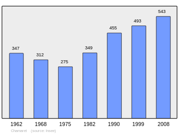
Chamaret is een gemeente in het Franse departement Drôme (regio Auvergne-Rhône-Alpes) en telt 493 inwoners (1999). De plaats maakt deel uit van het arrondissement Nyons.
Geografie
De oppervlakte van Chamaret bedraagt 7,8 km², de bevolkingsdichtheid is 63,2 inwoners per km².

Demografie
Onderstaande figuur toont het verloop van het inwonertal (bron: INSEE-tellingen).
Externe links
- (fr) Statistische informatie op de website van INSEE
Mediabestanden
Zie de categorie Chamaret van Wikimedia Commons voor mediabestanden over dit onderwerp.
- ↑ Populations légales 2021.


