National Register of Historic Places listings in Allegany County, Maryland
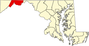
This is a list of the National Register of Historic Places listings in Allegany County, Maryland.
This is intended to be a complete list of the properties and districts on the National Register of Historic Places in Allegany County, Maryland, United States. Latitude and longitude coordinates are provided for many National Register properties and districts; these locations may be seen together in a map.[1]
There are 46 properties and districts listed on the National Register in the county.
Map all coordinates using OpenStreetMap
Download coordinates as:
- KML
- GPX (all coordinates)
- GPX (primary coordinates)
- GPX (secondary coordinates)
| Allegany - Anne Arundel - Baltimore (city) - Baltimore County - Calvert - Caroline - Carroll - Cecil - Charles - Dorchester - Frederick - Garrett - Harford - Howard - Kent - Montgomery - Prince George's - Queen Anne's - Somerset - St. Mary's - Talbot - Washington - Wicomico - Worcester |
This National Park Service list is complete through NPS recent listings posted May 10, 2024.[2]
Current listings
| [3] | Name on the Register[4] | Image | Date listed[5] | Location | City or town | Description |
|---|---|---|---|---|---|---|
| 1 | 16 Altamont Terrace |  | July 7, 1975 (#75000858) | Northeastern corner of the junction of Altamont Ter. and Union St. 39°39′07″N 78°45′23″W / 39.651944°N 78.756389°W / 39.651944; -78.756389 (16 Altamont Terrace) | Cumberland | |
| 2 | 200-208 Decatur Street |  | July 7, 1975 (#75000859) | 200, 202, 204, 206, and 208 Decatur St. 39°39′19″N 78°45′31″W / 39.655278°N 78.758611°W / 39.655278; -78.758611 (200-208 Decatur Street) | Cumberland | |
| 3 | African Methodist Episcopal Church |  | April 20, 1979 (#79001105) | Decatur and Frederick Sts. 39°39′22″N 78°45′34″W / 39.65616°N 78.75943°W / 39.65616; -78.75943 (African Methodist Episcopal Church) | Cumberland | |
| 4 | B'er Chayim Temple | 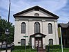 | November 15, 1979 (#79001106) | Union and S. Centre Sts 39°39′02″N 78°45′38″W / 39.650556°N 78.760556°W / 39.650556; -78.760556 (B'er Chayim Temple) | Cumberland | |
| 5 | Barton Village Site | Upload image | May 12, 1975 (#75000860) | Address Restricted | Cumberland | |
| 6 | Bell Tower Building | 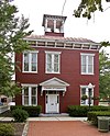 | February 20, 1973 (#73000881) | Bedford and Liberty Sts. 39°39′09″N 78°45′47″W / 39.6525°N 78.763056°W / 39.6525; -78.763056 (Bell Tower Building) | Cumberland | |
| 7 | Big Bottom Farm |  | June 7, 1984 (#84001319) | 14220 Hazen Road 39°43′07″N 78°41′44″W / 39.718611°N 78.695556°W / 39.718611; -78.695556 (Big Bottom Farm) | Dickens | |
| 8 | Borden Mines Superintendent's House |  | March 22, 1984 (#84001322) | Maryland Route 36 39°39′55″N 78°55′21″W / 39.665278°N 78.9225°W / 39.665278; -78.9225 (Borden Mines Superintendent's House) | Frostburg | |
| 9 | Breakneck Road Historic District | 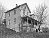 | May 29, 1980 (#80001777) | West of Flintstone 39°40′40″N 78°36′45″W / 39.677778°N 78.6125°W / 39.677778; -78.6125 (Breakneck Road Historic District) | Flintstone | |
| 10 | Wright Butler House | 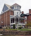 | January 31, 1978 (#78001440) | 205 Columbia St. 39°39′25″N 78°45′48″W / 39.656944°N 78.763333°W / 39.656944; -78.763333 (Wright Butler House) | Cumberland | |
| 11 | Canada Hose Company Building |  | September 21, 1979 (#79003257) | 400-402 N. Mechanic St. 39°39′21″N 78°46′07″W / 39.655833°N 78.768611°W / 39.655833; -78.768611 (Canada Hose Company Building) | Cumberland | |
| 12 | Chapel Hill Historic District |  | December 28, 2005 (#05001477) | Roughly bounded by Industrial Boulevard, an unnamed alley east of South St., and E. Oldtown Rd. 39°38′16″N 78°45′43″W / 39.637778°N 78.761944°W / 39.637778; -78.761944 (Chapel Hill Historic District) | Cumberland | |
| 13 | Chesapeake and Ohio Canal National Historical Park | 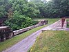 | October 15, 1966 (#66000036) | Bordering the Potomac River from Georgetown, D.C. to Cumberland, Maryland 39°37′31″N 78°45′34″W / 39.625278°N 78.759444°W / 39.625278; -78.759444 (Chesapeake and Ohio Canal National Historical Park) | Oldtown | |
| 14 | City Hall |  | February 27, 1973 (#73000882) | N. Center St. between Frederick and Bedford Sts. 39°39′10″N 78°45′46″W / 39.652778°N 78.762778°W / 39.652778; -78.762778 (City Hall) | Cumberland | |
| 15 | Michael Cresap House | 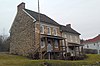 | April 14, 1972 (#72000563) | Main St. at Green Spring Rd. 39°32′30″N 78°36′42″W / 39.541667°N 78.611667°W / 39.541667; -78.611667 (Michael Cresap House) | Oldtown | |
| 16 | Cumberland YMCA |  | September 26, 1997 (#97001184) | 205 Baltimore Ave. 39°39′10″N 78°45′31″W / 39.652778°N 78.758611°W / 39.652778; -78.758611 (Cumberland YMCA) | Cumberland | |
| 17 | Decatur Heights Historic District |  | December 28, 2005 (#05001478) | Roughly along Baltimore Ave., Decatur St., Davidson St., Frederick St. and Linden St. 39°39′29″N 78°45′22″W / 39.658056°N 78.756111°W / 39.658056; -78.756111 (Decatur Heights Historic District) | Cumberland | |
| 18 | Downtown Cumberland Historic District |  | August 4, 1983 (#83002917) | Roughly bounded by Mechanic, Bedford, George, and Harrison Sts. 39°39′05″N 78°45′40″W / 39.651389°N 78.761111°W / 39.651389; -78.761111 (Downtown Cumberland Historic District) | Cumberland | |
| 19 | Evergreen |  | April 17, 2015 (#15000155) | 15603 Trimble Rd., NW. 39°40′58″N 78°52′34″W / 39.6827°N 78.8760°W / 39.6827; -78.8760 (Evergreen) | Mount Savage | |
| 20 | First Baptist Church |  | November 10, 1980 (#80001776) | 212 Bedford St. 39°39′21″N 78°45′41″W / 39.655833°N 78.761389°W / 39.655833; -78.761389 (First Baptist Church) | Cumberland | |
| 21 | Folck's Mill |  | November 21, 2008 (#08001071) | Address Restricted | Cumberland | |
| 22 | Footer's Dye Works |  | July 5, 2013 (#13000460) | South Mechanic and Howard Streets 39°38′55″N 78°45′43″W / 39.64852°N 78.76183°W / 39.64852; -78.76183 (Footer's Dye Works) | Cumberland | |
| 23 | Frostburg Historic District |  | September 8, 1983 (#83002918) | Western railroad line, Mt. Pleasant Terr., Main, Frost, Water, Broadway, Bealls, and Fairview Sts. 39°39′25″N 78°55′39″W / 39.656944°N 78.9275°W / 39.656944; -78.9275 (Frostburg Historic District) | Frostburg | |
| 24 | Greene Street Historic District |  | December 28, 2005 (#05001482) | Greene St. between Spruce Alley and Riverside 39°39′13″N 78°46′17″W / 39.653611°N 78.771389°W / 39.653611; -78.771389 (Greene Street Historic District) | Cumberland | |
| 25 | Francis Haley House |  | July 8, 1982 (#82002804) | 634 Maryland Ave. 39°38′46″N 78°45′21″W / 39.646111°N 78.755833°W / 39.646111; -78.755833 (Francis Haley House) | Cumberland | |
| 26 | Hocking House |  | December 2, 1982 (#82001579) | 144 E. Main St. 39°39′19″N 78°55′27″W / 39.655278°N 78.924167°W / 39.655278; -78.924167 (Hocking House) | Frostburg | |
| 27 | Inns on the National Road |  | December 22, 1976 (#76000976) | East and west of Cumberland on U.S. Route 40 from Flintstone to Grantsville 39°39′23″N 78°48′34″W / 39.656389°N 78.809444°W / 39.656389; -78.809444 (Inns on the National Road) | Cumberland | |
| 28 | Klots Throwing Company Mill |  | January 27, 2010 (#09001282) | 917 Gay St. 39°38′34″N 78°45′38″W / 39.642883°N 78.7606°W / 39.642883; -78.7606 (Klots Throwing Company Mill) | Cumberland | |
| 29 | Thomas Koon House |  | July 8, 1982 (#82002805) | 221 Baltimore Ave. 39°39′10″N 78°45′29″W / 39.652778°N 78.758056°W / 39.652778; -78.758056 (Thomas Koon House) | Cumberland | |
| 30 | La Vale Tollgate House | 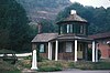 | January 25, 1971 (#71000363) | 14302 National Hwy., U.S. Route 40 39°38′15″N 78°51′06″W / 39.6375°N 78.851667°W / 39.6375; -78.851667 (La Vale Tollgate House) | La Vale | |
| 31 | Lonaconing Furnace |  | June 19, 1973 (#73000886) | E. Main St. 39°34′13″N 78°58′41″W / 39.570278°N 78.978056°W / 39.570278; -78.978056 (Lonaconing Furnace) | Lonaconing | |
| 32 | Lonaconing Historic District |  | September 15, 1983 (#83002919) | Maryland Routes 36 and 657, and Douglas Ave., Church, E. Main and Railroad Sts. 39°34′11″N 78°58′45″W / 39.569722°N 78.979167°W / 39.569722; -78.979167 (Lonaconing Historic District) | Lonaconing | |
| 33 | Mount Savage Historic District | 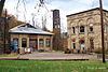 | September 8, 1983 (#83004213) | Roughly bounded by Foundry Row, Jennings Run, New School Rd., Yellow Row, Cherry St., and Columbia Ave. 39°41′47″N 78°52′49″W / 39.696389°N 78.880278°W / 39.696389; -78.880278 (Mount Savage Historic District) | Mount Savage | |
| 34 | Old National Pike Milestones | 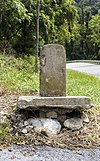 | November 27, 1975 (#75002107) | Maryland Routes 144 and 165, U.S. Route 40, U.S. Route 40 Alternate, and U.S. Route 40 Scenic 39°25′13″N 77°16′01″W / 39.420278°N 77.266944°W / 39.420278; -77.266944 (Old National Pike Milestones) | Bellegrove | |
| 35 | Phoenix Mill Farm |  | August 12, 1977 (#77000681) | Smouses Hill Road off Maryland Route 220 39°42′38″N 78°41′39″W / 39.710556°N 78.694167°W / 39.710556; -78.694167 (Phoenix Mill Farm) | Dickens | |
| 36 | Public Safety Building | 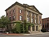 | April 13, 1973 (#73000883) | Frederick and Liberty Sts. 39°39′08″N 78°45′46″W / 39.652222°N 78.762778°W / 39.652222; -78.762778 (Public Safety Building) | Cumberland | |
| 37 | Rolling Mill Historic District |  | December 24, 2008 (#08001215) | Portions of Williams, Elm, Spring, Short, Baker, and Ascension Sts., Miltenberger Pl., Sheridan Pl., and Maryland Ave. 39°38′46″N 78°45′20″W / 39.646178°N 78.755689°W / 39.646178; -78.755689 (Rolling Mill Historic District) | Cumberland | |
| 38 | Shaw Mansion |  | June 19, 1985 (#85001345) | Laurel Run Cemetery Road 39°32′31″N 79°00′28″W / 39.541944°N 79.007778°W / 39.541944; -79.007778 (Shaw Mansion) | Barton | |
| 39 | Shawnee Old Fields Village Site | Upload image | May 12, 1975 (#75000150) | Address Restricted | Oldtown | |
| 40 | Town Clock Church |  | August 6, 1979 (#79001107) | 312 Bedford St. 39°39′25″N 78°45′40″W / 39.656944°N 78.761111°W / 39.656944; -78.761111 (Town Clock Church) | Cumberland | |
| 41 | George Truog House | 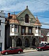 | September 11, 1986 (#86002382) | 230 Baltimore Ave. 39°39′13″N 78°45′29″W / 39.653611°N 78.758056°W / 39.653611; -78.758056 (George Truog House) | Cumberland | |
| 42 | Union Grove Schoolhouse |  | July 24, 1979 (#79001108) | Northeast of Cumberland on Mason Rd. 39°42′21″N 78°41′51″W / 39.705833°N 78.6975°W / 39.705833; -78.6975 (Union Grove Schoolhouse) | Dickens | |
| 43 | Washington Street Historic District |  | February 6, 1973 (#73000884) | Washington St. from Wills Creek to the middle of its 600 block, including Prospect Square 39°39′05″N 78°46′15″W / 39.651389°N 78.770833°W / 39.651389; -78.770833 (Washington Street Historic District) | Cumberland | |
| 44 | Waverly Street Bridge |  | September 7, 1984 (#84001327) | Waverly St. at Georges Creek 39°29′23″N 79°02′34″W / 39.489722°N 79.042778°W / 39.489722; -79.042778 (Waverly Street Bridge) | Westernport | |
| 45 | Western Maryland Railroad Right-of-Way, Milepost 126 to Milepost 160 |  | July 23, 1981 (#81000078) | Milepost 126 to Milepost 160 39°33′53″N 78°32′08″W / 39.564722°N 78.535556°W / 39.564722; -78.535556 (Western Maryland Railroad Right-of-Way, Milepost 126 to Milepost 160) | North Branch | |
| 46 | Western Maryland Railway Station | 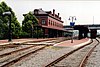 | June 19, 1973 (#73000885) | Canal St. 39°38′58″N 78°45′50″W / 39.649444°N 78.763889°W / 39.649444; -78.763889 (Western Maryland Railway Station) | Cumberland |
Former listing
| [3] | Name on the Register | Image | Date listed | Date removed | Location | City or town | Description |
|---|---|---|---|---|---|---|---|
| 1 | Queen City Hotel |  | March 12, 1971 (#71001052) | 1972 | Park and Harrison Sts. 39°39′01″N 78°45′27″W / 39.650144°N 78.757421°W / 39.650144; -78.757421 (Queen City Hotel) | Cumberland | Damaged by fire in 1969. Demolished in October 1971.[6] |
See also
Wikimedia Commons has media related to National Register of Historic Places in Allegany County, Maryland.
- List of National Historic Landmarks in Maryland
- National Register of Historic Places listings in Maryland
References
- ^ The latitude and longitude information provided in this table was derived originally from the National Register Information System, which has been found to be fairly accurate for about 99% of listings. Some locations in this table may have been corrected to current GPS standards.
- ^ National Park Service, United States Department of the Interior, "National Register of Historic Places: Weekly List Actions", retrieved May 10, 2024.
- ^ a b Numbers represent an alphabetical ordering by significant words. Various colorings, defined here, differentiate National Historic Landmarks and historic districts from other NRHP buildings, structures, sites or objects.
- ^ "National Register Information System". National Register of Historic Places. National Park Service. April 24, 2008.
- ^ The eight-digit number below each date is the number assigned to each location in the National Register Information System database, which can be viewed by clicking the number.
- ^ "Queen City Hotel being demolished". The Baltimore Sun. October 25, 1971. p. C6. Retrieved July 6, 2022 – via Newspapers.com.
- v
- t
- e

by county
 Category:National Register of Historic Places in Maryland
 Portal:National Register of Historic Places


Municipalities and communities of Allegany County, Maryland, United States | ||
|---|---|---|
County seat: Cumberland | ||
| Cities |  | |
| Towns | ||
| CDPs |
| |
| Other communities | ||
| ||


