Haftkel County
County in Khuzestan province, Iran
County in Khuzestan, Iran
Haftkel County Persian: شهرستان هفتکل | |
|---|---|
County | |
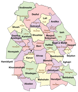 Location of Haftkel County in Khuzestan province (center, green) | |
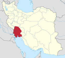 Location of Khuzestan province in Iran | |
| Coordinates: 31°33′N 49°27′E / 31.550°N 49.450°E / 31.550; 49.450[1] | |
| Country |  Iran Iran |
| Province | Khuzestan |
| Capital | Haftkel |
| Districts | Central, Raghiveh |
| Population (2016)[2] | |
| • Total | 22,119 |
| Time zone | UTC+3:30 (IRST) |
Haftkel County (Persian: شهرستان هفتکل) is in Khuzestan province, Iran. Its capital is the city of Haftkel.[3]
History
After the National Census of 2006, Haftkel District was separated from Ramhormoz County in the establishment of Haftkel County, which was divided into two districts and three rural districts, with Haftkel as its capital and only city at the time.[3]
Demographics
Population
The census in 2011 counted 22,391 people in 5,387 households.[4] At the 2016 census, Haftkel County's population was 22,119 in 5,908 households.[2]
After the census, the village of Raghiveh was elevated to the status of a city.[5]
Administrative divisions
Haftkel County's population history and administrative structure over two consecutive censuses are shown in the following table.
| Administrative Divisions | 2011[4] | 2016[2] |
|---|---|---|
| Central District | 17,056 | 17,245 |
| Howmeh RD | 2,179 | 1,443 |
| Haftkel (city) | 14,877 | 15,802 |
| Raghiveh District | 5,242 | 4,874 |
| Gazin RD | 1,355 | 1,135 |
| Raghiveh RD | 3,887 | 3,739 |
| Raghiveh (city)[a] | ||
| Total | 22,391 | 22,119 |
| RD = Rural District | ||
See also
![]() Media related to Haftkel County at Wikimedia Commons
Media related to Haftkel County at Wikimedia Commons
 Iran portal
Notes
References
- ^ OpenStreetMap contributors (31 July 2023). "Haftkel County" (Map). OpenStreetMap. Retrieved 31 July 2023.
- ^ a b c "Census of the Islamic Republic of Iran, 1395 (2016)". AMAR (in Persian). The Statistical Center of Iran. p. 06. Archived from the original (Excel) on 21 October 2020. Retrieved 19 December 2022.
- ^ a b Davodi, Parviz (29 July 2016). "The approval letter of the ministers who are members of the Political-Defense Commission of the Government Board regarding some changes and divisions of the country in Khuzestan province". Lamtakam (in Persian). Ministry of Interior, Political-Defense Commission of the Government Board. Archived from the original on 19 January 2024. Retrieved 27 January 2024.
- ^ a b "Census of the Islamic Republic of Iran, 1390 (2011)". Syracuse University (in Persian). The Statistical Center of Iran. p. 06. Archived from the original (Excel) on 18 January 2023. Retrieved 19 December 2022.
- ^ a b "Introduction of two new cities, Hati in Lali and Raghiveh in Haftkel". Asr-e Avalinha (in Persian). Ministry of Interior. 17 May 2016. Archived from the original on 31 July 2023. Retrieved 31 July 2023.
- v
- t
- e
Khuzestan Province, Iran

and cities
- Abadan's museum
- Gundishapur
- Acropole of Shush
- Apadana in Susa
- Arjan castle, Behbahan
- Asak ancient city, Hendijan
- Chagadom tappe fire temple
- Chogha Mish Proto-Elamite site
- Chogha Zanbil
- Dav o Dokhtar castle, Ramhormoz
- Dez Dam
- Eshkaft-e Salman
- Gargar bridge, Shushtar
- Haft Tepe
- Hoor-al-azim lagoon
- Imamzadeh Roudband, Dezful
- Imamzadeh Sabz-e-ghaba, Dezful
- Karkheh Dam
- Khorramshahr mosque, Battle of Khorramshahr
- Kul-e Farah
- lake of Karkheh dam
- Lake of Karun
- Lali bridge
- Meyangaran lagoon
- Rangooni's mosque
- Salasel castle, Shushtar
- Shadegan lagoon
- Shevi waterfall, Dezful
- Shush-Daniel
- Shushtar Historical Hydraulic System
- Shushtar Watermills
- Susa
- Shush Castle
- Taryana
- Tobiron valley, Dezful
- Tomb of Daniel, Shush
- White bridge, Ahvaz
- Ya'qub-i Laith's tomb, Dezful
Haftkel County | |
|---|---|
| Capital | |
| Districts | |


